
Bathurst Bridge (Toronto)
Historic 1903 steel Warren truss bridge spanning 10 tracks of Canada's busiest rail corridor, offering unobstructed elevated views of GO Transit, VIA Rail, UP Express, and occasional CN freight—all framed by the CN Tower.
Photos
![]() jargon777
jargon777
Attribution License
Trainspotting Experience
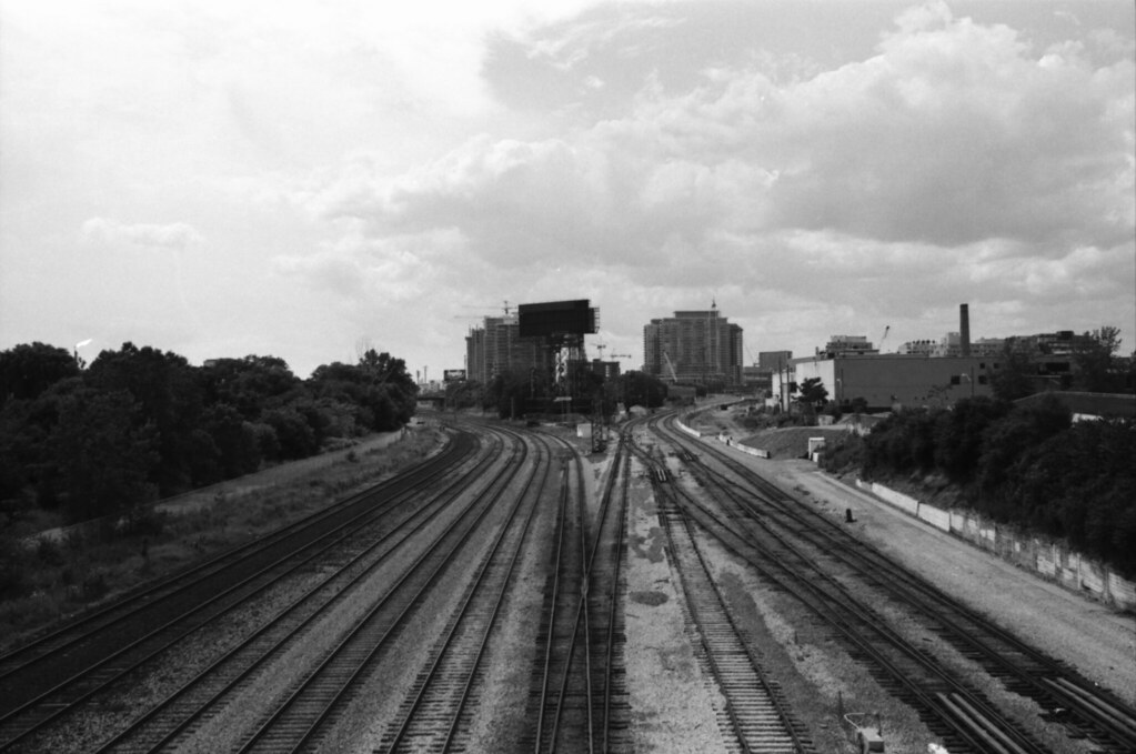
Bathurst Bridge—officially the Sir Isaac Brock Bridge since 2007—places you on wide concrete sidewalks roughly 10 metres above the western throat of the Union Station Rail Corridor (USRC). The bridge spans approximately 10 tracks at this point, including the Lakeshore West mainline, the Kitchener/UP Express corridor, and the approaches to North Bathurst Yard directly to the east. During weekday rush hours, trains appear in rapid succession: GO Transit bilevel consists on the Lakeshore West, Kitchener, Barrie, and Milton lines all funnel through this section, supplemented by UP Express Nippon Sharyo DMUs every 15 minutes and VIA Rail corridor services heading east toward Ottawa, Montreal, and Kingston or west toward London and Windsor. The TTC 511 Bathurst streetcar runs across the bridge deck itself, adding another layer of transit interest. Pedestrian traffic is manageable even during rush hour, and the sturdy steel railing provides a stable leaning point. Because the bridge sits at the western boundary of the USRC (Mile 1.1), you can watch trains diverging and converging through the Bathurst interlocking—one of four interlockings that control the corridor.
Landscape, Setting & Local Atmosphere
The bridge spans a wide open trench carved through what was once Toronto's industrial waterfront. To the south, the 43-acre Fort York National Historic Site sits behind its earthen ramparts, with the Gardiner Expressway elevated beyond. To the north, Front Street borders a rapidly changing neighbourhood of condo towers rising above older brick warehouses. Looking east, the CN Tower and the downtown skyline dominate the frame above the converging tracks, with the North Bathurst Yard storage tracks fanning out below. The corridor is largely clear of vegetation, keeping sightlines open year-round. Lake Ontario sits roughly 1 km to the south, and weather off the lake can shift quickly—summer afternoons bring haze and dramatic cloud formations, while clear winter days offer long shadows and crisp contrast across the stainless-steel bilevel coaches. At night, the corridor comes alive with signal LEDs, locomotive headlights, and the glow of the city reflecting off rolling stock.
Type & Frequency of Train Activity
The USRC is the busiest passenger rail corridor in Canada, serving over 72 million passengers annually through Union Station. At the Bathurst Bridge location, all westbound GO Transit lines converge into the corridor: the Lakeshore West line runs every 15–30 minutes all day (with 10-minute peak headways between Union and Oakville), while the Kitchener, Milton, and Barrie lines add further service during rush periods. The Union Pearson Express operates Nippon Sharyo DMU trainsets every 15 minutes from 5:30 AM to 1:00 AM, sharing the Kitchener corridor tracks. VIA Rail's Québec City–Windsor Corridor service accounts for an average of 39 daily train movements through Union Station, with Siemens Venture coaches now replacing the older fleet on many corridor runs. GO Transit operates bilevel coaches hauled by MPI MP40PH-3C locomotives in push-pull configuration, typically in 10- to 12-car consists during peak periods. Occasional Canadian National freight trains—usually mixed manifest or intermodal—thread through on the two southernmost tracks, particularly during overnight hours and weekends. North Bathurst Yard, visible from the bridge's east side, stores GO equipment between rushes and generates positioning moves throughout the day.
Best Angles for Photos & What Railfans Enjoy Most
The south sidewalk facing east is the classic shot: morning sun lights up locomotive noses and bilevel coaches with the CN Tower rising behind them. A wide-angle lens (24–35mm) captures the full breadth of the 10-track corridor and the skyline; switch to 70–200mm to isolate individual trains or frame engineer portraits at the roughly 20-metre working distance. The north sidewalk offers afternoon backlit silhouettes and the best angle on North Bathurst Yard with its stored equipment. The Warren truss structure provides natural framing for long-exposure night shots—the geometry of the steelwork combined with signal LEDs, headlights, and city neon creates strong compositions. Because the bridge lacks mesh fencing (post-2021 rehabilitation), lenses can be positioned through or over the railing gaps without obstruction. Westbound trains become visible as they emerge from under the Spadina Avenue bridge, giving several seconds of lead time to compose. For video, the simultaneous multi-track movements during rush hour—often three or more trains visible at once—make this location particularly rewarding.
Historical or Cultural Relevance
The steel Warren truss that forms the bridge was built in 1903 for the Lake Shore Road crossing over the Humber River. In 1916, it was disassembled, transported, and re-erected at Bathurst Street to extend the road across the expanding rail corridor to Fort York. The TTC Bathurst streetcar line was subsequently extended across the bridge through the old Fort grounds. In 1931, the bridge was realigned to straighten Bathurst Street's angled approach south of Front Street and to better support streetcar operations. The bridge was renamed the Sir Isaac Brock Bridge in 2007 at the urging of the Friends of Fort York, honouring the British major general killed at the Battle of Queenston Heights in 1812. Nearby, Cabin D—a Grand Trunk Railway interlocking tower built in 1890—originally stood in the corridor just west of the bridge before being relocated to Roundhouse Park in 1983, where it is now on display at the Toronto Railway Museum. The corridor itself gained its flyunder grade separation in 1983, allowing Lakeshore West trains to cross under Kitchener/Milton corridor trains without conflicting at grade. In 2020, the bridge underwent a major rehabilitation including truss repainting, new concrete deck, replacement of TTC tracks and overhead wire, new railings, and sidewalk restoration.
What Makes This Spot Different
Bathurst Bridge sits at the precise western boundary of the USRC (Mile 1.1), where Canada's busiest rail corridor fans out from the approach tracks into the 14-track terminal complex. This gives it a uniquely layered view: mainline corridors, yard leads, and stored equipment are all visible simultaneously. Unlike many urban train-watching spots, it requires zero trespassing or special access—the bridge is a public roadway served by the 511 Bathurst streetcar and is a short walk from King Street West or the Bathurst streetcar stop at Fort York Boulevard. The combination of GO commuter trains, VIA intercity consists, UP Express airport DMUs, and occasional CN freight creates a variety of rolling stock that few single locations in North America can match. Fort York National Historic Site is literally steps away to the south, and the Toronto Railway Museum at Roundhouse Park is a 10-minute walk east, making it possible to combine active railfanning with indoor exhibits on the same visit. Plans for a future GO station at North Bathurst Yard, near Front and Bathurst streets, could further increase the spot's interest and accessibility.
Frequently Asked Questions
QHow do I get to Bathurst Bridge by public transit?
Take the TTC 511 Bathurst streetcar to the Fort York Boulevard stop, which is on the bridge itself. Alternatively, take the 504 King streetcar to Bathurst Street and walk south to the bridge. The nearest subway station is St. Andrew on Line 1, about a 15-minute walk west along King Street.
QHow many trains pass through per day?
The corridor sees an estimated 200+ train movements per weekday, including GO Transit commuter trains on multiple lines, VIA Rail corridor service averaging 39 daily trains, UP Express every 15 minutes, and occasional CN freight. Weekend traffic is lighter but still substantial.
QIs there parking near the bridge?
Metered street parking is available on Front Street West and nearby side streets. Green P public parking lots are located at 250 Fort York Boulevard (near the Fort York Visitor Centre) and at 800 Fleet Street. Given the area's density, public transit is recommended.
QCan I combine this with other railway attractions?
Yes—the Toronto Railway Museum at Roundhouse Park is a 10-minute walk east along the rail corridor, housing historic locomotives, a miniature railway, and the restored Cabin D signal tower that was originally located near this bridge. Fort York National Historic Site is directly south of the bridge with free admission.
QWhat equipment do I need for good photos?
A 24-35mm wide-angle captures the full corridor and skyline. A 70-200mm telephoto isolates individual trains at the 20-metre working distance. The bridge lacks mesh fencing after its 2021 rehabilitation, so unobstructed shots are possible. A polarizing filter helps cut haze on summer days.
Safety Tips
Stay on the bridge sidewalks at all times—the rail corridor below is active 24/7 and strictly off-limits to pedestrians. The bridge carries motor vehicles and TTC streetcars, so watch for traffic when crossing to switch sidewalks. The 2020–2021 rehabilitation installed new railings, but exercise caution leaning over them with camera equipment. Wind gusts can be significant on the exposed bridge deck, particularly in winter when Lake Ontario winds funnel through the corridor. The sidewalks are maintained by the City of Toronto and can be icy in winter—wear appropriate footwear.
Seasonal Information
Spring and fall offer the best photography conditions, with lower sun angles that backlight or sidelight trains dramatically. Summer brings long daylight hours (sunrise before 6 AM, sunset after 9 PM) but frequent haze off Lake Ontario can soften distant skyline details. Winter provides the clearest air and sharpest contrast, but cold winds off the lake make extended sessions uncomfortable without proper layering—wind chill on the exposed bridge can drop well below ambient temperature. GO Transit runs reduced weekend schedules, so weekdays offer the densest traffic. The Lakeshore West line now operates 15-minute weekend service between Union and Oakville (as of April 2025), making weekends increasingly viable for spotting.
Nearby Lodging
- Hotel X Toronto by Hyatt
Waterfront hotel at Exhibition Place, about 1 km southwest of the bridge. City skyline and lake views, full-service spa and pool.
- Fairmont Royal York
Iconic 1929 railway hotel directly across Front Street from Union Station. Historic connection to rail travel, about 1.5 km east of the bridge.
- Delta Hotels by Marriott Toronto
Located near the Metro Toronto Convention Centre, roughly 1 km east of the bridge. Indoor pool and convenient access to the Entertainment District.
- 1 Hotel Toronto
Sustainable luxury hotel at the waterfront near Queens Quay, approximately 1.2 km southeast of the bridge.
Nearby Attractions
0.5 miles / 0.8 km
Located in the historic John Street Roundhouse (1929–1931), this museum houses restored locomotives, railcars, a miniature railway, and the restored Cabin D signal tower that originally stood near Bathurst Bridge.
0.1 miles / 0.2 km
A 43-acre national historic site built in 1793, directly south of the bridge. Free admission. Home to Canada's largest collection of original War of 1812 buildings and immersive exhibits.
0.7 miles / 1.2 km
Toronto's iconic 553-metre communications and observation tower, offering panoramic views of the rail corridor and city skyline.
0.5 miles / 0.8 km
A 17-acre park on the former Railway Lands featuring the restored CPR John Street Roundhouse, outdoor locomotive displays, turntable, and the Steam Whistle craft brewery.
0.9 miles / 1.5 km
Canada's busiest transportation hub (1927), a National Historic Site. The SkyWalk offers elevated views over the rail corridor, and the GO concourses provide platform-level access to trains.
External Links
informative
informative
informative
informative
informative
official
Looking for more spots? Browse the complete list of train spotting locations.
Quick Information
Country
Canada
Region
Ontario
City
Toronto
Spot Type
Bridge/Overpass
Best Times
Weekday morning rush (7–9 AM) and evening rush (4–7 PM) deliver peak GO Transit frequency with trains every few minutes. Midday offers steadier spacing at roughly 15–30 minute intervals on Lakeshore lines. UP Express runs every 15 minutes from 5:30 AM to 1:00 AM daily. For photography, morning light from the south sidewalk illuminates eastbound trains with the skyline behind them.
Visit Duration
1-3 hours
Cost
Free (public bridge). Metered parking nearby at $1.00 per half hour.
Train Activity
Train Types
Frequency
Estimated 200+ train movements per weekday across all operators (GO Transit on multiple lines, VIA Rail ~39 corridor trains daily, UP Express every 15 minutes, plus occasional CN freight)
Access & Amenities
Parking
Available (Metered street parking and Green P lots nearby (~$1.00 per half hour))
Shelter
Not available
Restrooms
Not available