

Cape Horn (Donner Pass)
A historic railroad cut on Union Pacific's Roseville Subdivision, carved 1,300 feet above the North Fork American River by Central Pacific workers in 1865-66. Double-track mountain railroading with 15+ daily freights and the California Zephyr.
Photos
![]() railfan 44
railfan 44
10
![]() railfan 44
railfan 44
10
![]() railfan 44
railfan 44
10
![]() railfan 44
railfan 44
10
![]() railfan 44
railfan 44
10
Trainspotting Experience
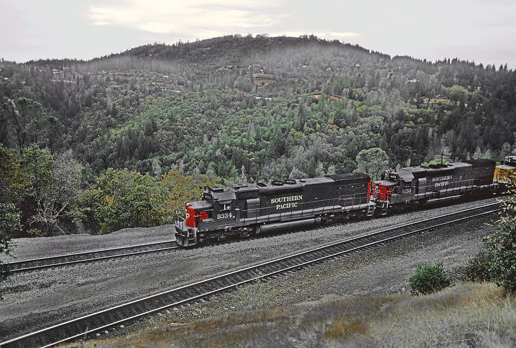
Cape Horn sits about three railroad miles east of Colfax on Union Pacific's Roseville Subdivision, the former Southern Pacific Donner Pass main line. The primary viewing spot is a roadside overlook at the Red Frog Bar & Grill parking lot on Highway 174, roughly one mile north of downtown Colfax. A stone bench with interpretive plaques — California Historical Landmark #780-9, dedicated in 1999 and revised in 2019 — faces south toward the promontory where the tracks curve around the mountainside about 1,300 feet above the North Fork of the American River.
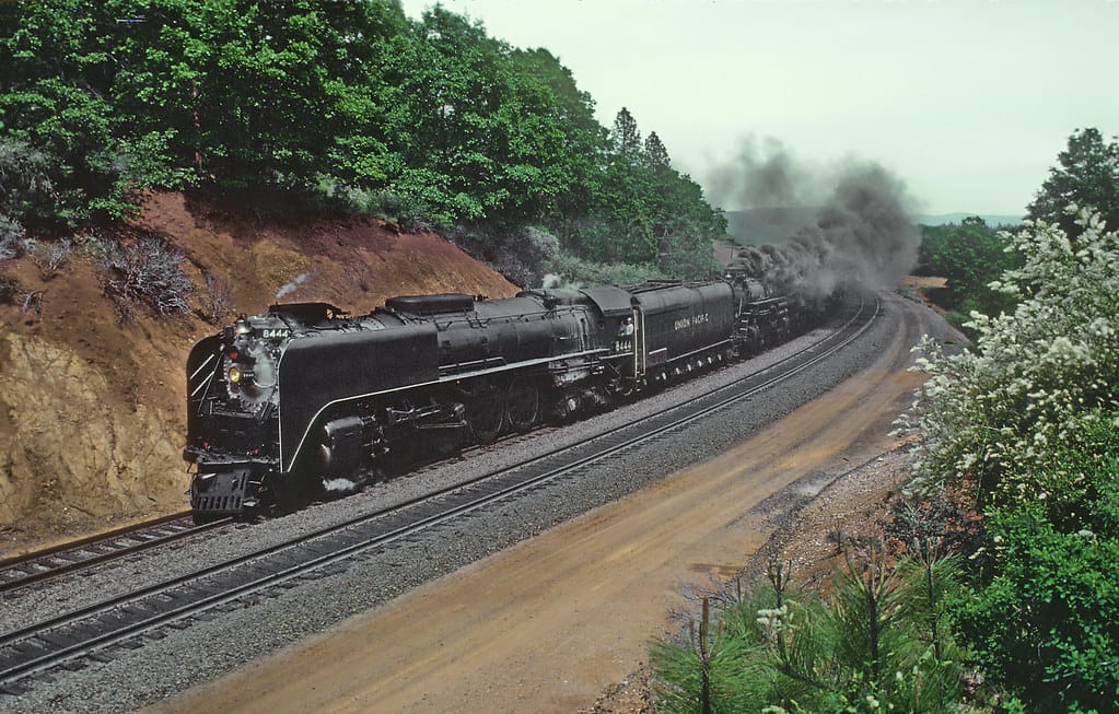
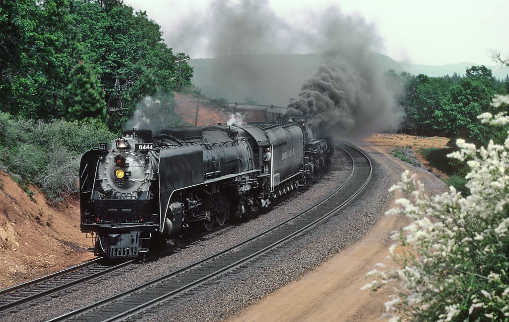
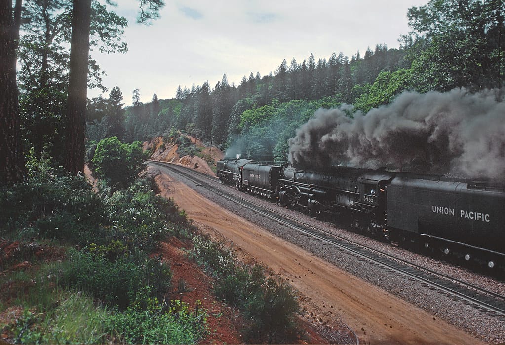
From this overlook, you can see trains approaching from the west as they climb out of Colfax at grades approaching 2.4% on Track 1. Speeds are moderate — typically 25-30 mph for eastbound freights grinding uphill, slightly faster for descending westbounds. Most loaded trains carry distributed power (DPU), with mid-train or rear helpers, so the full passage of a 9,000-foot intermodal can take several minutes. The roar of GE and EMD locomotives echoes off the canyon walls, punctuated by flange squeal on the tight curves.
For a more immersive view, the Stevens Trail — a BLM-managed path starting from North Canyon Way off I-80 Exit 135 — descends into the canyon and offers glimpses of the tip of Cape Horn from below. The trail is 3.2 miles one-way to the river and is listed on the National Register of Historic Places.
Landscape, Setting & Local Atmosphere
Cape Horn's elevation is approximately 2,730 feet according to the USGS Colfax Quadrangle, placing it on the western slope of the Sierra Nevada well below the snowline and summit. The terrain is a dramatic mix of exposed granite, Ponderosa pine, manzanita, and live oak clinging to steep escarpments. To the south, the canyon drops sharply toward the North Fork of the American River, with views reaching across to Iowa Hill ridge on the far side.
Summers are warm and dry with temperatures often exceeding 90°F, bringing canyon updrafts and occasional haze from pine resin. Clear mornings offer golden side-lighting ideal for photography. Late afternoons bathe the rock face in warm, reddish tones. Winter brings occasional dustings of snow at track level, though heavy accumulation generally occurs higher up toward Donner Summit (7,056 feet). The Donner Pass area averages over 400 inches of snow annually at the summit, but Cape Horn sees far less. Spring wildflower season (April-May) adds color to the canyon slopes and makes the Stevens Trail particularly scenic.
Type & Frequency of Train Activity
Union Pacific has operated the Donner Pass line since acquiring Southern Pacific in 1996. The Roseville Subdivision sees an estimated 15-20+ freight trains per day, consisting primarily of intermodal double-stacks, manifest freight, autoracks, and grain trains. Since a 2009 tunnel-notching project, domestic double-stack containers can clear the tunnels on Track 1, though 11 tunnels on Track 2 between Bowman and Colfax remain un-notched, requiring dispatchers to route all stack trains via Track 1 in that segment.
Motive power is predominantly GE ES44AC/C4 and EMD SD70ACe units. Heavy eastbound trains typically run 4-7 locomotives including DPU sets. The line is double-tracked with bidirectional signaling — UP dropped the old SP practice of directional running (westbound on Track 1, eastbound on Track 2) in favor of flexible dispatching from Omaha.
Amtrak's California Zephyr (trains #5 westbound and #6 eastbound) passes through daily, with a scheduled stop at Colfax station. The eastbound Zephyr typically departs Colfax mid-morning, while the westbound arrives in late afternoon, though on-time performance varies. Colfax is one of the few points on the Zephyr's 51-hour route where the two daily trains pass within minutes of each other if both are running on schedule.
Best Angles for Photos & What Railfans Enjoy Most
The Highway 174 overlook at the Red Frog offers a distant but dramatic perspective looking south toward the promontory. A 200mm or longer telephoto lens is useful for compressing the train against the canyon backdrop from this vantage point. Morning light favors eastbound trains, which are side-lit by sun rising over the canyon; late afternoon light works well for westbound descents.
The Highway 174 bridge over the two main tracks just north of the Colfax depot provides an overhead angle of trains entering or leaving the Colfax area. From the bridge, you can look south down the mainline toward downtown.
For wider canyon perspectives, the Stevens Trail (access from North Canyon Way, off I-80 Exit 135) offers views of Cape Horn from below and across. About one mile down the trail, you can glimpse the promontory and photograph trains curving along the cliff face with the river far below. A wide-angle lens (24-35mm) captures the full scale of the canyon setting from trail viewpoints.
Note that UP right-of-way along the tracks is private property and not accessible to the public. Drone operations near railroad infrastructure should comply with FAA regulations and maintain safe distance from active rail lines.
Historical or Cultural Relevance
Cape Horn is one of the most storied locations on the First Transcontinental Railroad. When Central Pacific tracks reached Colfax (then called "Illinoistown") on September 1, 1865, the railroad faced its first major obstacle: carving a three-mile roadbed around a steep, rocky promontory more than 1,300 feet above the North Fork of the American River. Chief Engineer Samuel S. Montague reported in November 1865 that "the work at Cape Horn has proved less difficult and expensive than was first anticipated." The ledge was completed by May 1866.
The work was performed largely by Chinese laborers, who comprised roughly 80% of Central Pacific's workforce by 1868. A popular legend holds that workers were lowered in wicker baskets to drill and blast the cliff face — a story that first appeared in a 1927 Southern Pacific Bulletin article. Historians, including Edson T. Strobridge, have disputed this account, noting that the actual slope was around 50 degrees rather than vertical. In 2019, the Colfax Historical Society replaced the original 1999 commemorative plaque at the overlook to correct this historical error.
In 1913, a tunnel was bored through the mountain for a second main track, allowing directional running over the pass. The Colfax passenger depot, built by Southern Pacific in 1905 in their standard "Colonnade" style, still serves as an Amtrak stop and now houses the Colfax Heritage Museum. The depot is listed on the National Register of Historic Places (1999).
What Makes This Spot Different
Cape Horn's combination of historical significance and active mountain railroading sets it apart from most other Donner Pass viewpoints. While locations like Yuba Gap, Soda Springs, and the Summit Tunnel area offer more dramatic snowshed and tunnel scenery, Cape Horn provides the deepest canyon perspective on the entire route — a sheer drop of over 1,300 feet to the river below, with the tracks carved into a narrow shelf on the mountainside.
The site is also uniquely accessible: the Highway 174 overlook requires no hiking, scrambling, or trespass, and the interpretive plaques provide historical context that connects the busy UP freight corridor to its 1860s origins. Few active railroad locations in North America offer such a direct visual link between a transcontinental railroad's construction heritage and modern heavy-haul operations.
Colfax itself is worth exploring as a railroad town. The restored 1905 depot, walkable historic downtown, and proximity to both the Sierra foothills and the Gold Country make it a natural base for a multi-day Donner Pass railfan trip.
Frequently Asked Questions
QHow many trains per day pass Cape Horn?
Union Pacific typically runs 15-20+ freight trains daily on the Roseville Subdivision, plus one daily Amtrak California Zephyr round trip (trains #5 and #6). Traffic can fluctuate based on seasonal demand and routing decisions between Donner Pass and the alternate Feather River Route.
QHow do I get to the Cape Horn viewpoint?
From I-80, take Exit 135 to Highway 174 (toward Grass Valley). The overlook is about one mile north of Colfax, at the Red Frog Bar & Grill parking lot (1001 Highway 174). A stone bench with historical plaques faces the canyon. For Stevens Trail access, head to North Canyon Way off I-80 Exit 135.
QWhat is the historical significance of Cape Horn?
Cape Horn was one of the first major engineering challenges on the First Transcontinental Railroad. From September 1865 to May 1866, Central Pacific workers — largely Chinese laborers — carved a railroad bed around a rocky promontory more than 1,300 feet above the American River. It is California Historical Landmark #780-9.
QCan I walk to the railroad tracks at Cape Horn?
No. The UP right-of-way is private property and trespassing is illegal and dangerous. The best public viewpoints are the Highway 174 overlook and the Stevens Trail. The Highway 174 bridge over the tracks near Colfax depot also offers views.
QWhat radio frequency covers Cape Horn?
The Roseville Subdivision dispatcher operates on 160.320 MHz (Dispatcher 74). You can monitor train movements with a scanner tuned to this frequency.
Safety Tips
The Highway 174 overlook is roadside with no barriers — use caution near the cliff edge, especially with children. The Stevens Trail is steep and exposed in places; it is not recommended for small children or dogs and requires adequate water in summer. The canyon can be extremely hot in July-August. Union Pacific right-of-way along the tracks is private property — stay on public land at all times. Rattlesnakes are present in the canyon during warmer months.
Seasonal Information
Spring (April-May) offers comfortable temperatures, wildflowers on the Stevens Trail, and generally clear skies. Summer brings heat (90°F+) but long daylight hours. Fall (September-October) provides mild weather and golden light. Winter is cool at canyon level (30-50°F) with occasional fog in the river gorge at dawn. The Stevens Trail can be muddy after rain. Higher elevations on Donner Pass may be snow-covered while Cape Horn remains clear. Train traffic is relatively consistent year-round, though winter storms can disrupt operations on the summit.
Nearby Lodging
- Best Western Colfax
Opened 2021, 69 rooms with modern amenities. Located at 801 South Auburn Street, about 1 mile from downtown Colfax. Pool, fitness center, free breakfast.
- Colfax Motor Lodge
Classic 18-room roadside motel at 550 South Auburn Street, walking distance to downtown Colfax. Family-owned, budget-friendly.
- Holiday Inn Auburn
Full-service hotel in Auburn, about 15 miles west of Colfax on I-80. More dining and shopping options nearby.
- Long Ravine Campground (Rollins Lake)
RV and tent camping on Rollins Lake, a few miles north of Colfax off Highway 174. Store, showers, boat launch.
Nearby Attractions
0.9 miles / 1.5 km
Housed in the restored 1905 Southern Pacific "Colonnade" depot at 99 Railroad Street, with railroad exhibits, local history, and a gift shop. Open Tue-Sun, 9 AM - 2 PM.
0.3 miles / 0.5 km
Historic 3.2-mile trail descending into the North Fork American River Canyon with views of Cape Horn. Listed on the National Register of Historic Places.
60 miles / 97 km
One of North America's premier railroad museums with 21 restored locomotives, a reconstructed 1876 depot, and extensive exhibits on transcontinental railroad history.
12 miles / 19 km
Preserves the history of the narrow gauge line that once connected Colfax to Nevada City (1876-1942). Features restored rolling stock and exhibits.
40 miles / 64 km
Commemorates the Donner Party and includes the Emigrant Trail Museum. Also provides access to Coldstream Canyon where UP tracks make a large horseshoe turn.
External Links
informative
informative
official
informative
Looking for more spots? Browse the complete list of train spotting locations.
Quick Information
Country
USA
Region
California
City
Colfax
Spot Type
Mountain Pass
Best Times
Morning to early afternoon for eastbound trains lit by side-light. The westbound California Zephyr typically passes Colfax in late afternoon. Scanner frequency for the Roseville Sub dispatcher is 160.320 MHz (Dispatcher 74).
Visit Duration
1-3 hours (overlook only: 30 minutes; with Stevens Trail hike: half day)
Cost
Free. No fees for the overlook or Stevens Trail parking.
Train Activity
Train Types
Frequency
15-20+ freight trains per day, plus one daily Amtrak California Zephyr round trip
Access & Amenities
Parking
Available (Free parking at the Red Frog Bar & Grill lot on Highway 174. Additional free parking at the Stevens Trail trailhead on North Canyon Way.)
Shelter
Not available
Restrooms
Not available