
East Dubuque (CN/BNSF)
BNSF and CN diamond crossing at East Cabin, where CN's Dubuque Subdivision emerges from an 1868 tunnel to cross BNSF's busy Aurora Subdivision along the Mississippi River.
Photos
![]() davidwilson1949
davidwilson1949
Attribution License

![]() davidwilson1949
davidwilson1949
Attribution License
Trainspotting Experience
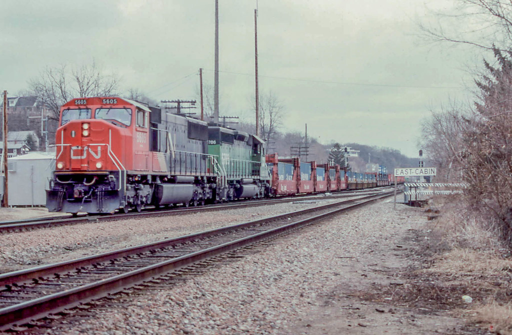
East Dubuque's East Cabin diamond sits where CN's Dubuque Subdivision crosses BNSF's Aurora Subdivision at track level, barely half a mile south of the Dubuque Rail Bridge over the Mississippi. Railfans set up along Sinsinawa Avenue or the parallel riverside access road to watch the action. BNSF trains roll through on the Aurora Sub's double-track mainline, part of the Northern Transcon corridor linking Chicago to the Pacific Northwest. CN trains approach from the east through an 851-foot tunnel bored under a 150-foot limestone bluff, negotiate a sharp 90-degree curve, cross the BNSF diamond, then continue onto the swing bridge into Dubuque, Iowa. The interplay between the two railroads creates varied movements: long BNSF intermodal stacks thundering along the river, CN trains appearing suddenly from the tunnel portal, and the crossing itself triggering horn sequences from both directions. Scanner traffic on 161.100 MHz (BNSF Aurora Sub North, AAR 66) and 161.190 MHz (CN ex-IC lines, AAR 72) helps anticipate approaching movements.
Landscape, Setting & Local Atmosphere
The spot sits in the Driftless Area, the unglaciated region of the upper Mississippi Valley known for its rugged bluffs and deep river valleys. On the Illinois side, a 150-foot limestone bluff rises sharply above the tracks, with the CN tunnel punched directly through its base. To the west, the Mississippi River runs roughly 600 feet wide at this point, with downtown Dubuque's skyline and church steeples visible on the Iowa bank. The BNSF mainline runs along a narrow shelf between the bluff face and the river, giving the scene a dramatic sense of compression. The surrounding bluffs are covered in hardwood forest — oaks, maples, and hickories that produce vivid fall color from late September through mid-October. Barge traffic on the river adds another layer of transportation activity, with Lock and Dam No. 11 located about 3 miles upstream at Eagle Point.
Type & Frequency of Train Activity
BNSF's Aurora Subdivision is the eastern segment of the Northern Transcon, the railroad's premier Chicago-to-Seattle corridor. Traffic through East Dubuque is predominantly intermodal (double-stacked containers), unit grain trains, crude oil unit trains, mixed manifest freight, and coal empties. While BNSF's Northern Transcon as a whole handles significant volume (the connecting St. Croix Subdivision in Wisconsin sees 55-60 trains daily), exact counts at East Dubuque have not been independently confirmed but are estimated at 40-50 trains per day based on corridor capacity. CN's Dubuque Subdivision carries considerably lighter traffic — an estimated 5-7 trains per day according to local observers and bridge traffic records. CN movements consist of manifest freight and occasional grain trains connecting the Freeport, Illinois area to Dubuque and points in Iowa via the swing bridge. No passenger service operates through East Dubuque; Amtrak's Black Hawk was the last passenger train on the CN route, discontinued in 1981.
Best Angles for Photos & What Railfans Enjoy Most
The east portal of the CN tunnel is the signature shot. Position along Sinsinawa Avenue looking east to capture CN trains emerging from the stone-and-concrete arch portal with the limestone bluff towering above. A 70-200mm zoom works well to compress the tunnel mouth and approaching locomotive. For BNSF action, set up west of the diamond looking east along the Aurora Sub — morning light favors this angle with the bluffs as backdrop. The diamond crossing itself is best captured from a safe distance with a wider lens (35-70mm) to show both railroads' track alignments converging. For a broader scene including the Mississippi River and Dubuque Rail Bridge, move north along Sinsinawa Avenue where the CN bridge approach becomes visible. Late afternoon offers backlit silhouettes of trains on the bridge against the western sky. The elevated vantage from US Route 20 above provides an overview of the entire junction area, though at greater distance.
Historical or Cultural Relevance
East Dubuque's railroad history dates to the 1850s when the Illinois Central Railroad pushed westward to reach the Mississippi. The IC constructed the tunnel through the limestone bluff in 1868, with the first dynamite charge set off on February 21 and daylight breaking through on October 3 of that year. The tunnel was built at an estimated depth of 65 feet, running 851 feet through solid rock with a demanding 90-degree curve. Rock excavated from the tunnel was used to build bridge piers for the adjacent Dubuque Rail Bridge, which opened in December 1868 as one of the first rail crossings of the upper Mississippi. The original swing bridge was built by Andrew Carnegie's Keystone Bridge Company and operated by the Dunleith & Dubuque Bridge Company. It was rebuilt in the 1890s and last rehabilitated in 2012. Meanwhile, the Chicago, Burlington & Quincy Railroad (CB&Q) built its own line along the river, eventually becoming the Aurora Subdivision. In 1888, Illinois Central acquired a parallel track from the Burlington Route between Portage and East Cabin, operating both tracks as double-track for both railroads. In 1994, Burlington successor BNSF gained control of this segment. CN acquired the Illinois Central in 1999, inheriting the tunnel, bridge, and Dubuque Subdivision. The Chicago Great Western Railway also historically used IC trackage rights through East Dubuque to reach Dubuque before the CGW's 1968 merger with the Chicago & North Western.
What Makes This Spot Different
The combination of a tunnel, a diamond crossing, and a Mississippi River bridge within half a mile makes East Dubuque a uniquely compact railfan location. The CN tunnel is one of only four active railroad tunnels remaining in Illinois, and its 90-degree curve means trains appear to emerge at a perpendicular angle to their approach — a disorienting and photogenic effect. The diamond at East Cabin (BNSF milepost 184.6 on the Aurora Sub) creates mandatory horn sequences and occasional meets where trains from both railroads converge simultaneously. The Dubuque Rail Bridge, with its operable swing span, occasionally opens for river traffic, adding maritime action to the rail scene. The site is also historically significant as the tunnel construction in 1868 was an early use of dynamite in American railroad building, and the bridge it served was among the first rail crossings north of Clinton, Iowa on the Mississippi.
Frequently Asked Questions
QIs there really a tunnel at East Dubuque?
Yes. The CN tunnel was built by the Illinois Central Railroad in 1868. It runs 851 feet through a limestone bluff with a 90-degree curve, connecting the Dubuque Subdivision to the Mississippi River bridge. Only CN trains use the tunnel — BNSF runs along the river without entering it.
QHow many trains pass through per day?
BNSF's Aurora Subdivision is part of the busy Northern Transcon and carries an estimated 40-50 trains daily. CN's Dubuque Subdivision is much lighter, with approximately 5-7 trains per day.
QWhat scanner frequencies should I monitor?
BNSF Aurora Sub North uses 161.100 MHz (AAR Channel 66). CN ex-Illinois Central lines use 161.190 MHz (AAR Channel 72). An EOTD/HOTD channel on 457.9375 MHz can alert you to approaching trains.
QIs there passenger train service here?
No. The last passenger train on this route was Amtrak's Black Hawk, which ran between Chicago and Dubuque until its discontinuation in 1981. There are periodic proposals to restore Chicago-Dubuque service, but none have been funded.
Safety Tips
Stay on public roadways and sidewalks along Sinsinawa Avenue. The BNSF mainline is extremely busy with trains approaching at track speed from both directions. The CN tunnel portal area may be on railroad property — photograph from the public road. Trains exiting the tunnel come around a blind 90-degree curve and can appear with little warning. The diamond crossing generates frequent horn blasts. Wear hearing protection during extended sessions.
Seasonal Information
Spring (April-May) brings migrating bald eagles along the Mississippi corridor and fresh greenery on the bluffs. Summer offers the longest shooting windows but can bring haze and humidity over the river. Fall (late September to mid-October) is prime season with hardwood color on the Driftless Area bluffs framing every shot. Winter brings potential for dramatic snow scenes and clearer air, but temperatures along the river can be bitter; the swing bridge may occasionally freeze.
Nearby Lodging
- Hotel Julien Dubuque
Historic boutique hotel in downtown Dubuque, 2 miles from the spot. Originally built in 1839, fully renovated. Walking distance to the Port of Dubuque attractions.
- Grand Harbor Resort and Waterpark
Full-service resort on the Dubuque waterfront, 2 miles from the spot. Indoor waterpark, river views, adjacent to the National Mississippi River Museum.
- TownePlace Suites by Marriott Dubuque Downtown
Extended-stay hotel in downtown Dubuque with kitchenettes. About 2 miles from the spot via the Julien Dubuque Bridge.
- Best Western Plus Dubuque Hotel & Conference Center
Mid-range chain hotel on US 20 in Dubuque, about 4 miles from the spot. Easy highway access for railfans also visiting other locations in the tri-state area.
Nearby Attractions
2 miles / 3.2 km
Major museum in Dubuque's Port of Dubuque complex, featuring river history exhibits, aquariums, and a National Rivers Hall of Fame. Includes railroad history displays relevant to Mississippi River crossings.
2 miles / 3.2 km
Billed as the world's shortest and steepest scenic railway, this funicular connects downtown Dubuque to the blufftop residential area. Offers panoramic views of the Mississippi River valley and rail corridors.
3 miles / 4.8 km
Blufftop park in Dubuque overlooking Lock and Dam No. 11 on the Mississippi River. Excellent vantage point for viewing barge traffic and the river landscape upstream of the rail bridge.
3 miles / 4.8 km
State recreation area south of Dubuque with hiking trails through Driftless Area bluffs. The Julien Dubuque Monument overlooks the Mississippi from a limestone bluff similar to those at the spotting location.
20 miles / 32 km
Well-preserved 19th-century lead mining town 20 miles southeast. Home of Ulysses S. Grant, with a vibrant main street, museums, and scenic drives through the Driftless Area landscape.
External Links
informative
informative
informative
Looking for more spots? Browse the complete list of train spotting locations.
Quick Information
Country
USA
Region
Illinois
City
East Dubuque
Spot Type
Junction
Best Times
BNSF traffic runs around the clock on the Northern Transcon, so any time can be productive. CN movements are less predictable given the low train count (5-7/day). Monitor scanner frequencies to time CN arrivals. Morning light favors eastward-facing shots toward the tunnel; late afternoon suits westward shots toward the river and bridge.
Train Activity
Train Types
Frequency
BNSF: estimated 40-50 trains/day (Northern Transcon corridor). CN: estimated 5-7 trains/day.
Access & Amenities
Parking
Not available
Shelter
Not available
Restrooms
Not available