Mattawamkeag (CSX/Eastern Maine Railway)
Mattawamkeag is the northernmost and easternmost point on the CSX network, where CSX (formerly Pan Am Railways) interchanges with J.D. Irving's Eastern Maine Railway at the confluence of the Penobscot and Mattawamkeag Rivers in rural northern Maine.
Photos
Trainspotting Experience
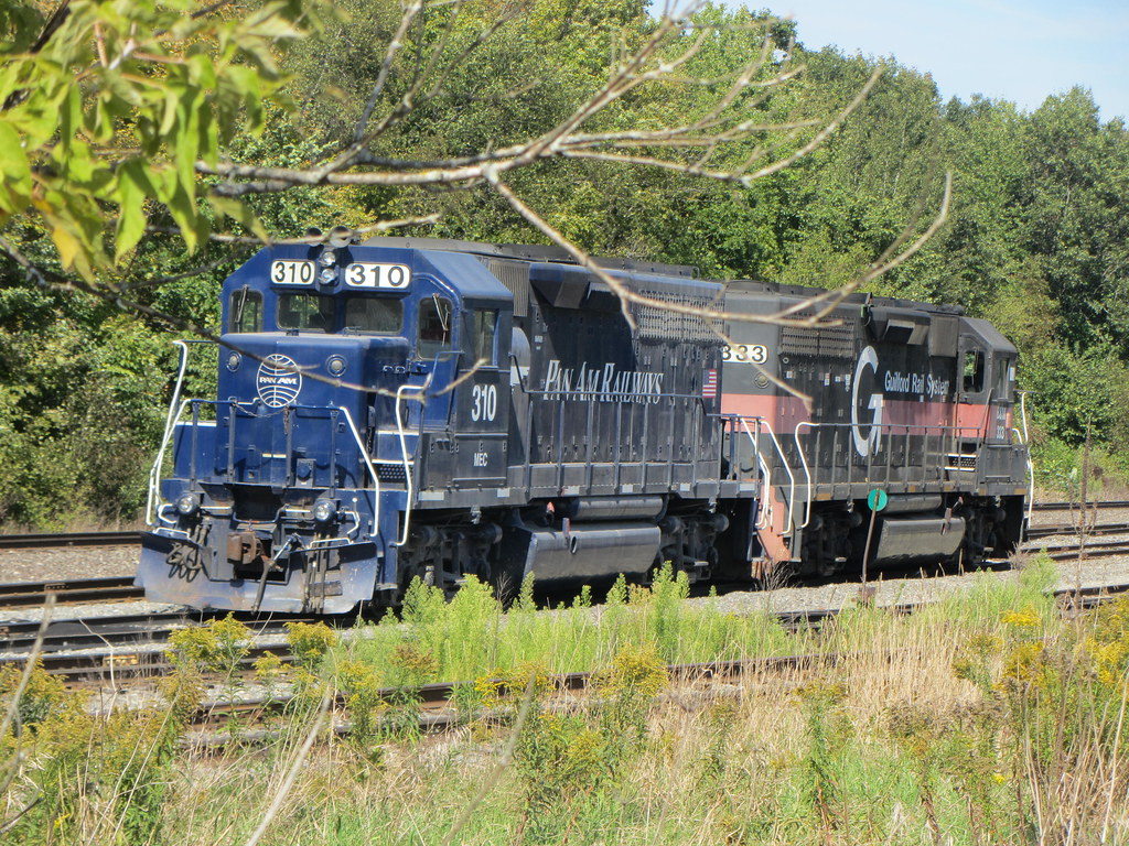
Mattawamkeag is about as remote as railfanning gets in the eastern United States. The town sits 60 miles north of Bangor along Route 2, at the point where the Mattawamkeag River flows into the Penobscot. The railroad yard is small but historically significant — this is Milepost 1 on the former Pan Am Railways system, as Guilford Transportation recalculated all mileage from here when it combined Maine Central with Boston & Maine.
Viewing opportunities center around the public grade crossings in the village and the area near the yard. Trains move slowly through town — typically 25 mph or less, reflecting the FRA Class II track standards CSX has restored on this corridor since late 2023. The pace is ideal for photography but don't expect constant action: Mattawamkeag sees only a handful of trains daily. What you do see, however, carries real interest — CSX road power exchanging cars with NBSR/EMRY units painted in the Irving fleet livery.
Cell service is limited. The nearest fuel, food, and supplies are in Lincoln, about 13 miles southwest. Bring everything you need for the day. Mosquitoes and black flies are fierce from late May through July — insect repellent is not optional. In winter, temperatures regularly drop below 0°F (-18°C), so dress accordingly.
Landscape, Setting & Local Atmosphere
Mattawamkeag occupies a river-junction setting at roughly 300 feet elevation in the heart of northern Maine's boreal forest. The Penobscot River — Maine's second-longest — flows southward through town, joined here by the Mattawamkeag River whose name derives from a Penobscot word meaning "river of gravelly banks." Dense stands of spruce, fir, and birch press close to the railroad right-of-way on all sides.
Autumn transforms the landscape with intense foliage color from late September through mid-October, framing locomotives against brilliant reds and golds. Winter brings stark, monochrome scenes with snow covering the ballast and ice forming along the rivers. The atmosphere is profoundly quiet between train movements — just the sound of the rivers and occasional birdsong. The town itself has a population of about 596 (2020 census), and there is virtually no industrial noise or traffic.
Type & Frequency of Train Activity
The interchange at Mattawamkeag was dormant for nearly five years before CSX restored service in December 2023 after extensive track upgrades between Old Town and Mattawamkeag raised speeds from 10 mph to 25 mph (with 15 miles now at FRA Class III / 40 mph standards). CSX now interchanges directly with the Eastern Maine Railway (EMRY), a J.D. Irving subsidiary, eliminating the previous routing through Brownville Junction via CPKC.
CSX operates freight service using road power — the first train back in December 2023 was handled by a pair of former Pan Am C40-8s (originally CSX units), delivering 47 cars to the NBSR interchange. Expect CSX GE-built power (ES40DCs, ES44AHs) on manifest and merchandise freight. EMRY/NBSR typically uses GP38-series locomotives in the Irving fleet livery. Traffic is dominated by forest products (lumber, wood chips, pulp), chemicals, and merchandise freight connecting New England with the Port of Saint John, New Brunswick.
Mattawamkeag was also formerly home to Perma Treat, a tie-recycling facility located alongside the yard that ground old railroad ties into wood chips for shipment to the Rumford paper mill. No passenger service operates through Mattawamkeag.
Best Angles for Photos & What Railfans Enjoy Most
The compact size of the Mattawamkeag yard actually works in the photographer's favor — you can cover the key angles on foot within the village. The CSX main line approaches from the southwest along the Penobscot River valley, while EMRY trackage diverges eastward toward Vanceboro and northwestward toward Brownville Junction.
Grade crossings in the village provide ground-level broadside and going-away shots. For trains approaching from the southwest, afternoon light is favorable as it sidelights westbound movements. Morning light works better for eastbound EMRY trains heading toward Vanceboro. A 70-200mm telephoto lens is ideal for compressing trains against the forested backdrop, while a wider lens (24-35mm) captures the full yard scene with the surrounding wilderness.
In autumn, the river and foliage create natural framing opportunities. The Penobscot River occasionally produces morning fog that adds atmosphere to early shots. Winter offers clean, high-contrast scenes with snow on the ground, though short daylight hours limit the shooting window.
Historical or Cultural Relevance
Mattawamkeag has been a railroad junction since 1869, when the European & North American Railway completed its line up the Penobscot River valley from Bangor. By 1871, the track extended east to Vanceboro at the New Brunswick border, creating a rail link to Saint John. In 1889, the Canadian Pacific Railway completed the International Railway of Maine from Lac-Mégantic, Quebec, to Mattawamkeag, placing this small town on CPR's transcontinental main line to the ice-free winter port of Saint John.
For decades, Mattawamkeag was a crucial junction where Maine Central (which leased the E&NA in 1882 and purchased the Mattawamkeag–Vanceboro segment in 1955) interchanged with Canadian Pacific. In 1974, CPR purchased the Mattawamkeag–Vanceboro tracks outright. When CPR divested its eastern lines in 1994, J.D. Irving formed the Eastern Maine Railway to purchase the Mattawamkeag Subdivision trackage.
Maine Central was purchased by Guilford Transportation Industries in 1981. Guilford (rebranded as Pan Am Railways in 2006) recalculated its mileage system using Mattawamkeag as Milepost 1. Years of deferred maintenance under Guilford/Pan Am degraded the line to 10 mph speeds, effectively strangling traffic. CSX acquired Pan Am Railways in June 2022 and has since invested heavily in rehabilitation, restoring direct interchange at Mattawamkeag in December 2023.
What Makes This Spot Different
Mattawamkeag is the northernmost and easternmost point on the entire CSX Transportation network — a distinction that alone makes it notable for railfans seeking to document the system's extremities. The location offers the rare opportunity to witness interchange operations between a Class I railroad and an Irving family short line in a completely rural, forested setting with no fences, sound walls, or urban clutter.
The December 2023 reopening of direct CSX–EMRY interchange here, after nearly five years of dormancy, marks a significant chapter in the ongoing rehabilitation of the former Pan Am Railways system. For railfans interested in railroad history and corporate evolution, Mattawamkeag encapsulates over 150 years of railroad ownership changes: from the European & North American Railway (1869) through Maine Central, Canadian Pacific, Guilford Transportation, Pan Am Railways, and now CSX.
Frequently Asked Questions
QWhat railroads operate at Mattawamkeag?
CSX Transportation (which acquired Pan Am Railways in June 2022) interchanges with Eastern Maine Railway (EMRY), a J.D. Irving subsidiary that connects to New Brunswick Southern Railway and ultimately to the Port of Saint John, New Brunswick.
QHow many trains per day pass through Mattawamkeag?
Traffic is light — typically a few trains per day in each direction since CSX restored direct interchange in December 2023. This is a low-density line where patience is rewarded.
QIs there food or fuel in Mattawamkeag?
Very limited services in the village itself. Lincoln, about 13 miles southwest on Route 2, has gas stations, restaurants (Pat's Pizza, Gillmor's), and a grocery store.
QWhen did CSX reopen the Mattawamkeag interchange?
CSX ran the first train to Mattawamkeag in nearly five years on December 4, 2023, after upgrading the former Pan Am line from 10 mph to 25 mph standards between Old Town and Mattawamkeag.
QCan I camp near the trainspotting location?
Yes. Mattawamkeag Wilderness Park, about 8 miles from town, offers 50 campsites including RV hookups, Adirondack shelters, and tent sites along the Mattawamkeag River. Open seasonally (typically May to October).
Safety Tips
Stay well clear of all tracks and equipment. CSX and EMRY trains may operate at any hour without advance notice. The yard and surrounding trackage are private railroad property — photograph only from public roads and crossings. Cell service is limited in this area; let someone know your plans before visiting. The nearest emergency services are in Lincoln, approximately 13 miles away.
Seasonal Information
Summer (June–August) offers the longest daylight hours but mosquitoes and black flies are severe — bring strong repellent. Fall (late September to mid-October) provides spectacular foliage as a backdrop. Winter is harsh, with temperatures regularly below 0°F and significant snow, but offers stark photographic contrast and fewer bugs. Spring (April–May) brings mud season and unpredictable weather. Road access via Route 2 is maintained year-round.
Nearby Lodging
- Mattawamkeag Wilderness Park Campground
Seasonal campground (May–October) with 50 sites including RV hookups, Adirondack shelters, and tent sites along the Mattawamkeag River. About 8 miles from the yard.
- Comfort Inn & Suites — Lincoln
Chain hotel in Lincoln, approximately 13 miles southwest of Mattawamkeag. Convenient base with dining options nearby.
- Katahdin Inn & Suites — Millinocket
Hotel in Millinocket, about 40 miles north. Good option if combining Mattawamkeag with a visit to Baxter State Park.
Nearby Attractions
8 miles / 13 km
1,000-acre park on the Mattawamkeag River with 15 miles of hiking trails, campsites, and river access. Features Gordon Falls and Slewgundy Heater Gorge.
60 miles / 97 km
Transportation museum in Bangor featuring historic trains, a Maine Central caboose, fire engines, and over 200 vintage vehicles.
50 miles / 80 km
Maine's newest national monument (established 2016) offering hiking, scenic driving, and wildlife viewing with views of Mount Katahdin.
50 miles / 80 km
Maine's highest peak (5,267 ft) and northern terminus of the Appalachian Trail. About an hour's drive from Mattawamkeag via Route 157.
40 miles / 64 km
Museum housed in the restored 1910 Bangor & Aroostook Railroad station with railroad memorabilia, a restored caboose, and a rare 1949 B&A BL2 diesel locomotive on display.
External Links
informative
informative
informative
informative
official
Looking for more spots? Browse the complete list of train spotting locations.
Quick Information
Country
USA
Region
Maine
City
Mattawamkeag
Spot Type
Yard/Depot
Best Times
Daylight hours. CSX interchange traffic with EMRY/NBSR is irregular; trains may arrive mid-morning or late afternoon. Patience is essential at this remote location.
Visit Duration
2-4 hours (bring patience for this low-traffic location)
Cost
Free
Train Activity
Train Types
Frequency
Low — a few trains per day in each direction since CSX resumed service in December 2023. Traffic is expected to grow as CSX upgrades continue.
Access & Amenities
Parking
Available (Free — informal roadside parking near grade crossings)
Shelter
Not available
Restrooms
Not available