
Mobridge (Missouri River Bridge)
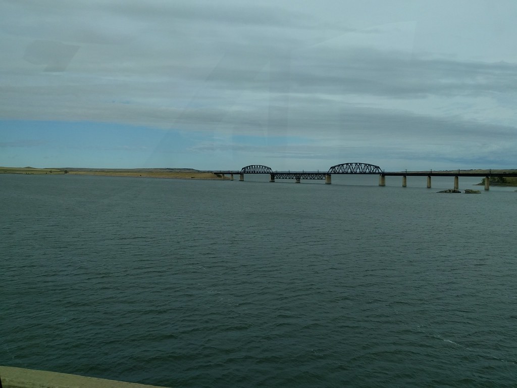
BNSF's Missouri River railroad bridge at Mobridge, South Dakota — a 1,820-foot through-truss span built in 1961 on the historic Milwaukee Road route, carrying grain and coal trains across Lake Oahe.
Photos
![]() sf-dvs
sf-dvs
4
Trainspotting Experience
Mobridge sits on BNSF's Mobridge Subdivision, a single-track overflow corridor running from Aberdeen, South Dakota (MP 707) to Hettinger, North Dakota (MP 926). The line is former Milwaukee Road trackage — part of the famed Pacific Extension that once reached the Pacific Coast. The State of South Dakota purchased the route after the Milwaukee Road's bankruptcy in the early 1980s, eventually selling it to Burlington Northern (now BNSF).
Traffic is modest compared to mainline corridors. The bridge carries an estimated 6 trains per day, though this fluctuates significantly with grain harvest cycles and Powder River Basin coal demand. BNSF reportedly uses a directional running pattern on this single-track line: empty trains head westbound one day, and loaded trains run eastbound the next. This means you might see several trains in one direction or none at all depending on the day.
The 1961 through-truss bridge stretches approximately 1,820 feet across the lake, with a 3,650-foot causeway on the northwest approach — roughly one mile of combined structure. Trains cross slowly on the single track, giving plenty of time to watch a full consist pass. From public areas near U.S. Highway 12 on the east approach, you can observe trains entering or exiting the bridge.
Landscape, Setting & Local Atmosphere
The railroad bridge crosses the Missouri River at Mobridge, where the waterway has been widened into Lake Oahe by the Oahe Dam downstream near Pierre. The river elevation here is approximately 1,605 feet. The eastern bank is relatively flat, bordered by cottonwoods and open grassland typical of the glacial prairie. The western shore rises more steeply, with clay bluffs above the waterline.
Mobridge sits in north-central South Dakota, about 110 miles north of Pierre. The landscape is expansive prairie with big skies — a dramatic setting for railroad photography. Summer temperatures reach the mid-80s °F, while winters are harsh, with temperatures frequently dropping well below zero. The Central/Mountain time zone boundary runs through this area (the US-12 highway bridge crosses it). The town itself has a population of about 3,260 (2020 census) and retains its railroad-era character, having been founded specifically because of the Milwaukee Road's river crossing.
Type & Frequency of Train Activity
The Mobridge Subdivision serves primarily as an overflow route for BNSF. Traffic consists of:
Grain unit trains — The core traffic on this line. Long strings of 110-car hopper consists move eastbound from Dakota grain elevators. Mobridge itself historically was a grain trading hub, and elevators remain visible in town.
Powder River Basin coal — When demand is high, unit coal trains use this route as an alternative to BNSF's busier main line through Bismarck, approximately 85 miles to the north.
Mixed manifest freight — Occasional mixed consists carry agricultural equipment, tank cars, and general merchandise.
There is no Amtrak or passenger service through Mobridge. South Dakota is unique among the lower 48 states in that it has never had Amtrak service. The nearest Amtrak route is the Empire Builder, which runs through North Dakota on BNSF's main line well to the north.
Best Angles for Photos & What Railfans Enjoy Most
The bridge's two through-truss spans, separated by deck truss sections, create a distinctive profile against the wide lake and prairie sky. The structure is visible from public areas near the U.S. Highway 12 corridor on the east side.
For full side profiles showing trains crossing the bridge, a telephoto lens (200-400mm range) isolates the steel structure against the water. Morning light from the east illuminates the bridge face. Wide-angle compositions (24-35mm) can capture the full extent of the bridge and causeway — over a mile of combined structure — with grain trains stretching across the steel.
The west bank offers higher vantage points from the bluff areas, though access should be verified as some areas may be on Standing Rock Reservation land. Always respect private property and reservation boundaries.
Given the low train frequency (roughly 6 per day), monitoring the BNSF Mobridge Subdivision scanner frequency at 161.385 MHz is strongly recommended to avoid long waits.
Historical or Cultural Relevance
The railroad bridge at Mobridge is inseparable from the town's very existence. The Chicago, Milwaukee, St. Paul and Pacific Railroad — the Milwaukee Road — began construction at this Missouri River crossing in 1906. A temporary wooden bridge was completed by April 1907 to support construction westward, and a permanent steel bridge opened on March 19, 1908. The Milwaukee Road reached Mobridge on September 9, 1906, and the first lot in the new town was sold on October 3, 1906.
The town's name comes from a telegrapher's abbreviation: an operator at the construction site signed his transmissions as "M.O.Bridge" — shorthand for "Missouri Bridge" — and the name stuck. This crossing was a critical link in the Milwaukee Road's ambitious Pacific Extension, which ultimately stretched from Chicago to the Pacific Coast.
The original bridge was demolished by the U.S. Army Corps of Engineers in the early 1960s because rising water levels from the Oahe Dam project would have submerged it. The current through-truss bridge was built in 1961, positioned south of the original crossing. After the Milwaukee Road's bankruptcy and dissolution in the 1980s, the State of South Dakota purchased this rail line, which was later leased to and eventually sold to Burlington Northern (now BNSF Railway).
What Makes This Spot Different
Mobridge is one of the few places where a town literally owes its name and existence to a railroad bridge. The crossing represents a surviving piece of the Milwaukee Road's Pacific Extension — one of the last great transcontinental railroad building campaigns in American history. While most of the Pacific Extension has been abandoned or dismantled, this bridge remains in active service under BNSF.
The bridge's unusual design sets it apart structurally: two through-truss spans separated by deck truss sections, rather than adjacent through-truss spans. This arrangement creates two navigation channels. The combined bridge and causeway length of approximately one mile makes for a cinematic crossing, with long grain unit trains taking several minutes to pass.
The remote prairie location and low traffic density (roughly 6 trains per day) mean this is a spot best suited for patient railfans willing to combine train watching with exploring the area's rich Native American and Lewis & Clark history. The Sitting Bull and Sakakawea monuments are just two miles southwest of town.
Frequently Asked Questions
QHow many trains per day cross the Mobridge bridge?
Approximately 6 trains per day, though this varies with grain harvest cycles and Powder River Basin coal demand. The line is a BNSF overflow corridor, not a primary main line.
QWhat railroad operates the Mobridge bridge?
BNSF Railway operates the bridge and the Mobridge Subdivision, which runs from Aberdeen, South Dakota to Hettinger, North Dakota. The line is former Milwaukee Road trackage.
QWhat is the scanner frequency for the Mobridge Subdivision?
161.385 MHz (AAR Channel 80) covers the Mobridge Subdivision from Aberdeen to Hettinger. The MRAS (Mobile Radio Access System) frequencies 160.665 and 161.310 MHz may also carry traffic.
QIs there any passenger train service through Mobridge?
No. South Dakota has never had Amtrak service. The nearest passenger rail is the Empire Builder route through North Dakota.
QWhen was the current railroad bridge built?
The current through-truss bridge was built in 1961 by the U.S. Army Corps of Engineers, replacing the original 1907-1908 Milwaukee Road bridge that was flooded by the Oahe Dam project.
Safety Tips
The railroad bridge and tracks are BNSF private property — do not trespass on the bridge, tracks, or rail right-of-way. Photograph from public roads and pulloffs near U.S. Highway 12. Some areas west of the river may be on Standing Rock Reservation land; respect all posted boundaries and obtain permission if needed. This is remote prairie country — carry water, check weather forecasts, and be prepared for sudden weather changes, especially in winter. Cell phone coverage can be limited in rural areas.
Seasonal Information
Summer (June-August) offers long daylight hours and warm temperatures around 85°F, ideal for photography. Grain traffic may increase during and after harvest season (late summer through fall). Winter temperatures regularly drop well below 0°F — hardy conditions, but cold weather produces atmospheric locomotive exhaust plumes. Spring and fall provide moderate weather; fall foliage along the river adds color to compositions. Lake Oahe water levels can vary seasonally, affecting the visual scale of the bridge over water.
Nearby Lodging
- Wrangler Inn Mobridge
Full-service hotel with heated pool, hot tub, fitness center, and restaurant. Pet-friendly. Centrally located in Mobridge.
- Mobridge Kountry Inn
Top-rated family-owned motel with continental breakfast, WiFi, and large parking lot. TripAdvisor Travelers' Choice. Pet-friendly with bird cleaning station for hunters.
- Dave's East Side Mobridge
Variety of accommodations from motel rooms to cabins and houses. Renovated properties catering to fishermen, families, and business travelers.
Nearby Attractions
2 miles / 3.2 km
Monuments overlooking the Missouri River on SD Highway 1806. The Sitting Bull bust was sculpted by Korczak Ziolkowski (of Crazy Horse Memorial fame). Listed on the National Register of Historic Places since 2006.
0.9 miles / 1.5 km
Local museum displaying Native American artifacts, pioneer history, and agricultural exhibits reflecting Mobridge's railroad and farming heritage.
0.6 miles / 1 km
Historic arena in downtown Mobridge housing vivid murals by renowned Yanktonai Sioux artist Oscar Howe, depicting scenes from Dakota life and culture.
6.2 miles / 10 km
Lake Oahe recreation area offering camping, fishing, boating, and swimming along the scenic lakeshore, south of Mobridge.
0.3 miles / 0.5 km
National Park Service historical marker at the site of the original 1906-1908 railroad bridge, located on the Lewis & Clark Interpretive Trail along the waterfront.
External Links
informative
informative
Looking for more spots? Browse the complete list of train spotting locations.
Quick Information
Country
USA
Region
South Dakota
City
Mobridge
Spot Type
Bridge/Overpass
Best Times
Train frequency is low at roughly 6 per day, so patience is required. No fixed schedule exists for this overflow corridor. Monitoring BNSF scanner frequency 161.385 MHz (AAR Channel 80, Mobridge Subdivision) helps time arrivals.
Visit Duration
1-3 hours (patience required due to low train frequency)
Cost
Free — public viewing from highway pulloffs
Train Activity
Train Types
Frequency
Approximately 6 trains per day (estimated). Traffic varies with grain harvest and coal demand from the Powder River Basin. BNSF reportedly operates directional running — empty trains west one day, loaded trains east the next.
Access & Amenities
Parking
Available (Free — informal pulloffs along U.S. Highway 12)