
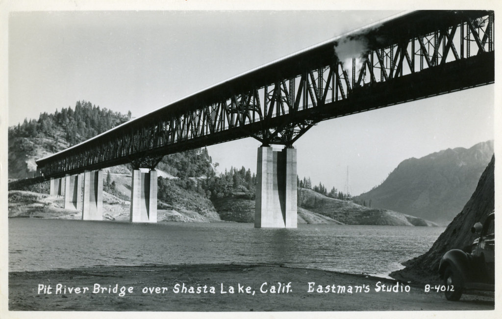
Pit River Bridge (Shasta Lake)
The Pit River Bridge is the only double-deck road-rail bridge of its kind in California, carrying Interstate 5 on its upper deck and Union Pacific Railroad on its lower deck over Shasta Lake. Built in 1942 as part of the Shasta Dam project, this 3,588-foot steel deck truss span—officially the Veterans of Foreign Wars Memorial Bridge—is structurally the highest double-decked bridge in the United States, standing 500 feet above the original Pit River bed. Watching Union Pacific freight and Amtrak's daily Coast Starlight cross the bridge against the backdrop of Shasta Lake makes it a one-of-a-kind trainspotting destination.
Photos
![]() waterarchives
waterarchives
5
Trainspotting Experience
Trains on the former Southern Pacific Shasta Route emerge from forest cuts, cross the steel deck truss of the lower railroad deck, and disappear into tunnel portals on the opposite shore. Because the bridge sits only about 40 feet above the water when Shasta Lake is full, trains appear to skim the lake surface—a dramatically different visual from the 500-foot drop to the original Pit River bed below. The lower railroad deck spans 2,754 feet, so a long intermodal train takes over a minute to cross at normal speeds. Union Pacific operates this corridor as its primary Portland–Sacramento freight artery; Amtrak's Coast Starlight (#11 southbound and #14 northbound) also crosses the bridge once daily in each direction. The I-5 pullout on the south end of the bridge and the Centimudi Boat Ramp area provide accessible ground-level viewing near the shore. During drought conditions, additional historic railroad trestles and tunnel portals along the lake emerge from the receding water, making the entire Shasta Lake railroad relocation visible in ways normally impossible.
Landscape, Setting & Local Atmosphere
Shasta Lake is the largest reservoir in California, formed by the impounding of three rivers—the Sacramento, McCloud, and Pit—behind Shasta Dam. The lake has 365 miles of shoreline lined with ponderosa pine, black oak, and manzanita on steep hillsides. The Pit River arm, where the bridge crosses, occupies a flooded canyon at approximately 1,065 feet elevation (full pool). Bald eagles and osprey are regularly seen fishing the lake. On clear winter mornings, the snow-capped cone of Mount Shasta is visible roughly 55 miles to the north. The bridge itself is a visual landmark from I-5, where the massive Warren truss spans—the longest at 630 feet—stand above the water on concrete piers built dry during original construction.
Type & Frequency of Train Activity
Union Pacific operates the former Southern Pacific Shasta Route (Black Butte Subdivision) across this bridge as its main Portland–Sacramento corridor. Traffic is mixed freight: intermodal stack trains, manifest freight, unit grain trains from the Pacific Northwest, and occasional lumber trains. Amtrak's Coast Starlight runs once daily in each direction—train #11 southbound (Los Angeles-bound) and train #14 northbound (Seattle-bound)—both crossing the bridge with Superliner equipment. Freight schedules vary; UP operates 24 hours and trains may pass at any hour. Distributed power configurations are common given the mountain grades approaching Dunsmuir to the north. Exact daily train counts are not publicly published by UP for this segment.
Best Angles for Photos & What Railfans Enjoy Most
The best vantage points are on the south end of the bridge accessible via Bridge Bay Road (I-5 Exit 690). From the Bridge Bay resort area near the water, telephoto lenses (200–400mm) can compress the bridge against the lake. The Centimudi Boat Ramp on the west side of the lake provides a broadside angle looking east toward the bridge over open water. From the I-5 southbound roadway itself, the railroad deck is visible below as you drive across—a unique perspective not possible at most railroad bridges. During low-water years (drought conditions), additional railroad infrastructure along the lakeshore becomes exposed, providing context for the massive 1938–1942 railroad relocation that created this structure. Morning light from the east illuminates the bridge trusses; late afternoon brings warm side-lighting from the west.
Historical or Cultural Relevance
The Pit River Bridge was built in 1942 as the centerpiece of a massive railroad and highway relocation forced by the construction of Shasta Dam. When the Bureau of Reclamation began filling the Shasta Lake reservoir, it submerged 26 miles of the original Southern Pacific Shasta Route, which had followed the Sacramento River canyon since the 1880s. A new 32-mile alignment was constructed 1938–1942, requiring a dozen new tunnels and four towering trestles including the Pit River Bridge. At the time of its construction, it was the highest railroad bridge in the United States (measured from the original river bed), and it remains structurally the highest double-decked road-rail bridge in the country. The bridge carries I-5 on its upper deck and UP's railroad on its lower—the only interstate highway bridge in the entire United States owned by the federal government, under a joint use agreement with Union Pacific that runs until 2040. In 1954, the bridge entered American cultural history when amateur photographer Virginia Schau captured a dramatic rescue on the bridge that won the Pulitzer Prize for Photography. Caltrans and the Bureau of Reclamation are now studying rehabilitation or replacement options before the 2040 agreement expires.
What Makes This Spot Different
No other bridge in the United States stacks an interstate highway directly above a Class I railroad main line at this scale—3,588 feet long on the upper deck, with the railroad deck running 2,754 feet below it. As the only federally owned interstate bridge in the country, it has an unusual ownership and governance structure that affects its future. The railroad perspective is itself unique: unlike typical bridges where the rail crosses high above a gorge, the Pit River rail deck at normal lake levels sits just ~40 feet above water, so trains appear nearly level with the lake surface. This creates striking photographic compositions impossible at most high railroad bridges. The entire Shasta Lake waterfront contains multiple additional railroad trestles and tunnel portals—all part of the same 1942 relocation—that become exposed during drought, turning the lake into an outdoor museum of mid-century railroad engineering.
Frequently Asked Questions
QIs there parking near the bridge to watch trains?
The Bridge Bay Resort area off I-5 Exit 690 (Bridge Bay Road) provides the closest public access near the water. The Centimudi Boat Ramp also offers waterfront access with parking on the western side of the Pit River arm. There is no dedicated railfan viewing platform.
QWhat trains use the Pit River Bridge?
Union Pacific freight trains on the Black Butte Subdivision use the bridge as part of the Portland–Sacramento corridor. Amtrak's Coast Starlight (trains #11 and #14) also crosses daily in each direction with Superliner passenger equipment.
QWhy is the bridge so low over the water if it is 500 feet tall?
The 500-foot height refers to the distance above the original Pit River bed before the reservoir was created. When Shasta Lake is at full pool (1,065 ft elevation), the railroad deck sits only about 40 feet above the water surface, as the lake has flooded the canyon below.
QIs the Pit River Bridge going to be replaced?
The highway portion of the bridge is under study for rehabilitation or replacement. Caltrans and the U.S. Bureau of Reclamation must resolve the bridge's future before a joint use agreement with Union Pacific expires in 2040. Plans generally call for retaining the existing structure for railroad use only if a new highway span is built.
Safety Tips
Do not attempt to access the railroad tracks or bridge structure. The tracks are active and the bridge is a working railroad bridge. Stay on public land at the resort and boat ramp areas.
Seasonal Information
The bridge can be observed year-round. Spring and fall offer mild temperatures and clearer air for photography. Summer brings high boat traffic on Shasta Lake and crowded resort areas. Winter can bring snow to the hillsides and occasional clear views of Mount Shasta to the north. During drought years, receding water levels expose historic railroad infrastructure along the lakeshore, making those periods particularly interesting for railroad history enthusiasts.
Nearby Lodging
- Bridge Bay Lodge at Shasta Lake
Lakeside motel-style lodge directly at the Bridge Bay Marina, steps from the water and a short walk to views of the Pit River Bridge. Pet-friendly. I-5 Exit 690.
- Holiday Harbor Resort
Full-service resort on the McCloud Arm of Shasta Lake near O'Brien (I-5 Exit 695), approximately 3 miles north of the bridge. Offers cabins, houseboat rentals, and marina access.
- Antlers Resort & Marina
Resort and campground in Lakehead on the Sacramento Arm of Shasta Lake. Good base for exploring the entire Shasta Lake area including the Pit River Bridge.
Nearby Attractions
8.5 miles / 14 km
Free guided tours of the second-largest concrete dam in the United States, including an elevator ride 400 feet inside the dam and a walk through to the spillway. The dam was the reason the Pit River Bridge was built in 1942. Open Friday–Tuesday, 8am–4pm.
6 miles / 10 km
A National Natural Landmark featuring guided tours of limestone caverns that began forming 250 million years ago. Tour includes a boat ride across Shasta Lake and a bus ride up 800 feet to the cavern entrance. The Grey Rocks formation is visible from I-5.
1.2 miles / 2 km
Full-service marina and resort at the base of the Pit River Bridge approach (I-5 Exit 690). Offers houseboat rentals, fishing boats, and the CookHouse waterfront restaurant. Good shoreline vantage point for photographing the bridge.
1.8 miles / 3 km
USFS public boat ramp on the western side of the Pit River arm of Shasta Lake, offering a broadside view of the Pit River Bridge across open water. Free access with parking.
External Links
Looking for more spots? Browse the complete list of train spotting locations.
Quick Information
Country
USA
Region
California
City
Lakehead
Spot Type
Bridge
Best Times
The best hours to observe trains at Pit River Bridge are during daylight, especially morning and late afternoon for optimal lighting and frequent train crossings.
Train Activity
Train Types
Frequency
UP freight runs 24 hours (count not published); Amtrak Coast Starlight once daily each direction
Access & Amenities
Parking
Available (false)
Shelter
Not available
Restrooms
Available