
Poughkeepsie (Hudson Bridge)
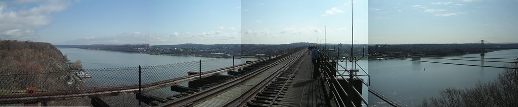
A former railroad bridge 212 feet above the Hudson River, now a 1.28-mile pedestrian walkway offering bird's-eye views of Metro-North Hudson Line and CSX River Subdivision trains on both riverbanks.
Photos
![]() Russ Nelson
Russ Nelson
Attribution-ShareAlike License
Trainspotting Experience
The Walkway Over the Hudson is a rare spot that lets you watch trains on two separate rail corridors simultaneously from 212 feet above the river. On the east bank, Metro-North's Hudson Line runs double-tracked along the shore, with Poughkeepsie Station visible just to the south. Trains accelerate and decelerate through the station area, giving prolonged viewing opportunities. On the west bank, CSX's River Subdivision—a single-track freight main stretching 132 miles between Selkirk, NY, and North Bergen, NJ—hugs the opposite shore.
The bridge deck is 6,768 feet (1.28 miles) long and 24 feet wide, with waist-high railings and a solid concrete walking surface. No trains cross the bridge itself—the rails were removed when the walkway opened in 2009. Tripods are perfectly stable since there is no vibration. The walkway is open daily from 7:00 AM until dusk, and admission is free. Access from the Poughkeepsie side is via a stairway at Washington Street (15-minute walk from the train station) or via a 21-story glass elevator at Upper Landing Park (3-minute walk from the station). The west side entrance is at 87 Haviland Road in Highland.
Landscape, Setting & Local Atmosphere
From the bridge deck you look north toward the Catskill Mountains and south toward the Hudson Highlands and Mount Beacon. The Hudson sweeps wide below in a north-south channel, flanked by hardwood forests and steep bluffs. In autumn the valley fills with reds, golds, and oranges; winter brings ice floes on the river and crystal-clear sightlines to distant peaks. The Mid-Hudson Bridge, a suspension bridge completed in 1930, is visible just downstream.
The deck sits high enough that wind is a constant factor—bring a windbreaker even on warm days. Dawn light strikes the east-bank tracks from behind the Catskills, while afternoon sun illuminates westbound views. The atmosphere is relaxed: walkers, joggers, cyclists, and dog owners share the path. You can hear train horns echoing off the river well before trains come into view, giving a useful heads-up for camera setup.
Type & Frequency of Train Activity
The east-bank Hudson Line is the main draw. Metro-North operates diesel-hauled service between Grand Central Terminal and Poughkeepsie (the line's northern terminus), running approximately 20+ round trips on weekdays with reduced weekend service. Since October 2025, new "super-express" trains using Siemens Charger diesel-electric locomotives make the run to Grand Central in under 90 minutes. North of Croton-Harmon, the line is not electrified and is mostly double-tracked.
Amtrak's Empire Service provides roughly hourly weekday service between New York Penn Station and Albany-Rensselaer, with some trains continuing to Buffalo and Niagara Falls—currently around 8-10 daily Empire Service trains stop at Poughkeepsie. The daily Maple Leaf (New York–Toronto), Lake Shore Limited (New York–Chicago), and Adirondack (New York–Montreal) also pass through. The section between Poughkeepsie and Schenectady has been leased by Amtrak from CSX since December 2012.
On the west bank, the CSX River Subdivision carries freight exclusively. A local news source reported that this line can see up to 20 freight trains per day. CSX is the primary operator, though occasional Norfolk Southern run-through power appears. Freight types include intermodal, mixed manifest, and crude oil trains. Scheduling is unpredictable—there is no published freight timetable.
Best Angles for Photos & What Railfans Enjoy Most
For east-bank Metro-North and Amtrak trains, position yourself slightly north of center span and shoot southward to capture trains curving into Poughkeepsie Station with the Mid-Hudson Bridge suspension cables as a backdrop. Morning light is front-lit from this angle. In the afternoon, shift toward the south-central portion of the walkway for pleasing sidelight on northbound consists.
For west-bank CSX freights, the south-central bays offer a broadside angle against forested cliffs. Because the deck has no overhead obstructions, you can experiment with straight-down shots of trains passing beneath—a perspective unavailable at trackside locations. Telephoto lenses in the 200-400mm range compress the river-valley scene nicely from this height, while a 24-35mm wide angle captures the full sweep of river and mountains.
Golden hour and blue hour are particularly rewarding: the river surface sometimes produces mirror-like reflections. During the vernal and autumnal equinoxes, the sun rises directly in line with the walkway deck—the park organizes "Sunrise Strolls" for these events.
Historical or Cultural Relevance
The Poughkeepsie-Highland Railroad Bridge opened on January 1, 1889, and was the longest bridge in the world at the time of its completion—6,768 feet spanning the Hudson between Poughkeepsie and Highland, NY. It was financed by the Manhattan Bridge Building Company (1886) with backing from Henry Clay Frick, and built by the Union Bridge Company. The bridge carried the Maybrook Line of the New York, New Haven & Hartford Railroad, providing the only fixed rail crossing of the Hudson south of Albany until the Bear Mountain Bridge opened to motorists in 1924.
At its peak, as many as 3,500 rail cars reportedly crossed the bridge daily, carrying coal, livestock, manufactured goods, and wartime materiel. The bridge was strengthened in 1907-1912 by engineer Ralph Modjeski, who added a third line of trusses. Tracks were converted to a gauntlet configuration in 1917-18 and later reduced to a single centered track in 1959. During World War II, the bridge was painted black as a precaution against attack.
On May 8, 1974, a fire—likely sparked by brakes on a passing Penn Central freight—damaged approximately 700 feet of decking on the east end. Penn Central's fire-suppression water pipes had burst from winter neglect. Rail service never resumed. Conrail sold the bridge in 1984; the nonprofit Walkway Over the Hudson acquired it in 1998 for one dollar. After a $38.6 million rehabilitation, the bridge reopened on October 3, 2009, as the Walkway Over the Hudson State Historic Park. It was designated a National Historic Civil Engineering Landmark by ASCE in 2009.
What Makes This Spot Different
This is one of the very few trainspotting locations where you can observe two completely separate railroad corridors simultaneously—passenger on the east bank, freight on the west—from an elevated vantage point that no trackside location can replicate. The 212-foot height reveals consist makeup, train length, and dispatching patterns at a glance, essentially providing an aerial perspective without needing a drone.
The location is also historically unique: you stand on a bridge that once carried trains itself, watching the railroad operations that evolved below after the bridge's own rail era ended. The juxtaposition of the 1889 bridge structure with modern Metro-North Chargers and CSX road power creates a visual contrast that spans over 130 years of American railroading. Add free admission, easy train access from New York City (Poughkeepsie is the last Metro-North stop), and 1.28 miles of unobstructed walking deck, and this becomes one of the most accessible and distinctive railfan spots in the Northeast.
Frequently Asked Questions
QCan you see trains from the Walkway Over the Hudson?
Yes. From the 212-foot-high bridge deck, you can see Metro-North and Amtrak trains on the east bank Hudson Line and CSX freight trains on the west bank River Subdivision. No trains cross the bridge itself.
QHow do I get to the Walkway from Poughkeepsie train station?
From Poughkeepsie Metro-North/Amtrak station, walk 3 minutes north to Upper Landing Park for the glass elevator (seasonal), or walk 15 minutes to the stairway entrance at Washington Street.
QIs the Walkway Over the Hudson free?
Yes. Admission is free. The park is open daily from 7:00 AM until dusk. Free parking is available on the Poughkeepsie side.
QHow many trains pass through Poughkeepsie daily?
On the east bank, expect roughly 20+ Metro-North trains plus 8-10 Amtrak trains on weekdays. On the west bank, CSX runs up to 20 freight trains per day, but timing is unpredictable.
QWhat camera lens should I bring?
A telephoto zoom in the 200-400mm range works well for compressing trains against the river valley landscape from 212 feet up. A wide-angle 24-35mm lens captures sweeping panoramas of the Hudson and both rail corridors.
Safety Tips
The walkway has waist-high railings on both sides—stay behind them at all times. Wind can be strong at 212 feet; secure loose items and camera straps. The deck surface is smooth concrete; it can become slippery when wet. Bicycles are permitted but skateboards are prohibited per park rules. The glass elevator on the Poughkeepsie side operates seasonally—check walkway.org for current hours. In summer, bring water and sun protection as there is no shade on the bridge deck.
Seasonal Information
Spring and fall offer the best combination of comfortable temperatures and scenic beauty—autumn foliage in the Hudson Valley typically peaks in mid-to-late October, creating a spectacular backdrop for train photography. Winter provides crystal-clear air and dramatic ice-floe views on the river, but wind chill at 212 feet can be severe. Summer offers the longest daylight hours but afternoon heat on the exposed deck can be intense. The park organizes special Sunrise Strolls during the equinoxes (around March 20 and September 22) when the sun rises directly in line with the bridge deck.
Nearby Lodging
- DoubleTree by Hilton Poughkeepsie
Opened in 2023, 0.5 miles from the train station. Free breakfast, free parking, and shuttle to the station. Downtown location.
- Hyatt Place Poughkeepsie / Hudson Valley
Modern hotel near Vassar College with indoor pool and free breakfast. About 5 miles from the Walkway. Pet-friendly.
- Holiday Inn Express Poughkeepsie
Mid-range option with shuttle service to the train station and complimentary breakfast.
- Courtyard by Marriott Poughkeepsie
Reliable chain hotel about 2.6 miles from the train station. Free parking and WiFi.
Nearby Attractions
6.8 miles / 11 km
The nation's first presidential library, located at FDR's Springwood estate in Hyde Park. Houses extensive archives and exhibits on FDR's presidency and WWII.
3.1 miles / 5 km
A 200-acre estate and museum centered on a 45-room Italianate villa designed for telegraph inventor Samuel Morse in 1851. Features nature trails and gardens.
13 miles / 21 km
Major contemporary art museum housed in a former Nabisco box-printing factory in Beacon, NY. One of the largest spaces for modern art in the US. Accessible by Metro-North (Beacon station).
2.2 miles / 3.5 km
Historic liberal arts college founded in 1861, with a free art museum housing over 5,000 works. Beautiful campus with notable architecture.
5 miles / 8 km
America's premier culinary college with four student-staffed restaurants open to the public. Located on a scenic campus overlooking the Hudson.
0.6 miles / 1 km
New York State's longest continuously running theater, hosting performances and events in the heart of downtown Poughkeepsie.
External Links
informative
informative
Looking for more spots? Browse the complete list of train spotting locations.
Quick Information
Country
USA
Region
New York
City
Poughkeepsie
Spot Type
Bridge/Overpass
Best Times
Weekday mornings (7-9 AM) and late afternoons (5-7 PM) offer the densest Metro-North traffic. CSX freights run around the clock with no fixed schedule, but railfans report some southbound activity between 6-10 AM weekdays.
Visit Duration
1-3 hours
Cost
Free admission. Parking is free on the east side; paid parking on the west side.
Train Activity
Train Types
Frequency
East bank (Hudson Line): approximately 20+ Metro-North trains plus 8-10 Amtrak Empire Service/Maple Leaf trains daily on weekdays. West bank (CSX River Sub): up to 20 freight trains per day, timing unpredictable.
Access & Amenities
Parking
Available (Free parking on the Poughkeepsie (east) side at Brookside Avenue and Pulaski Park on Washington Avenue. Paid parking on the Highland (west) side at Haviland Road via the Town of Lloyd.)
Shelter
Not available
Restrooms
Available