
Rockville Bridge
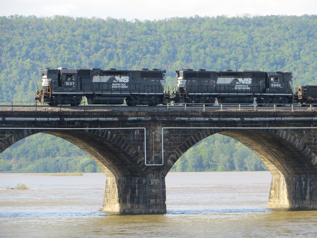
The world's longest stone masonry arch railroad bridge (3,820 ft, 48 arches), built in 1902 by the Pennsylvania Railroad. Carries Norfolk Southern's Pittsburgh Line and Amtrak's Pennsylvanian across the Susquehanna River, with 50-70 freight trains daily.
Photos
![]() davidwilson1949
davidwilson1949
Attribution License
![]() davidwilson1949
davidwilson1949
Attribution License
![]() davidwilson1949
davidwilson1949
Attribution License
Trainspotting Experience
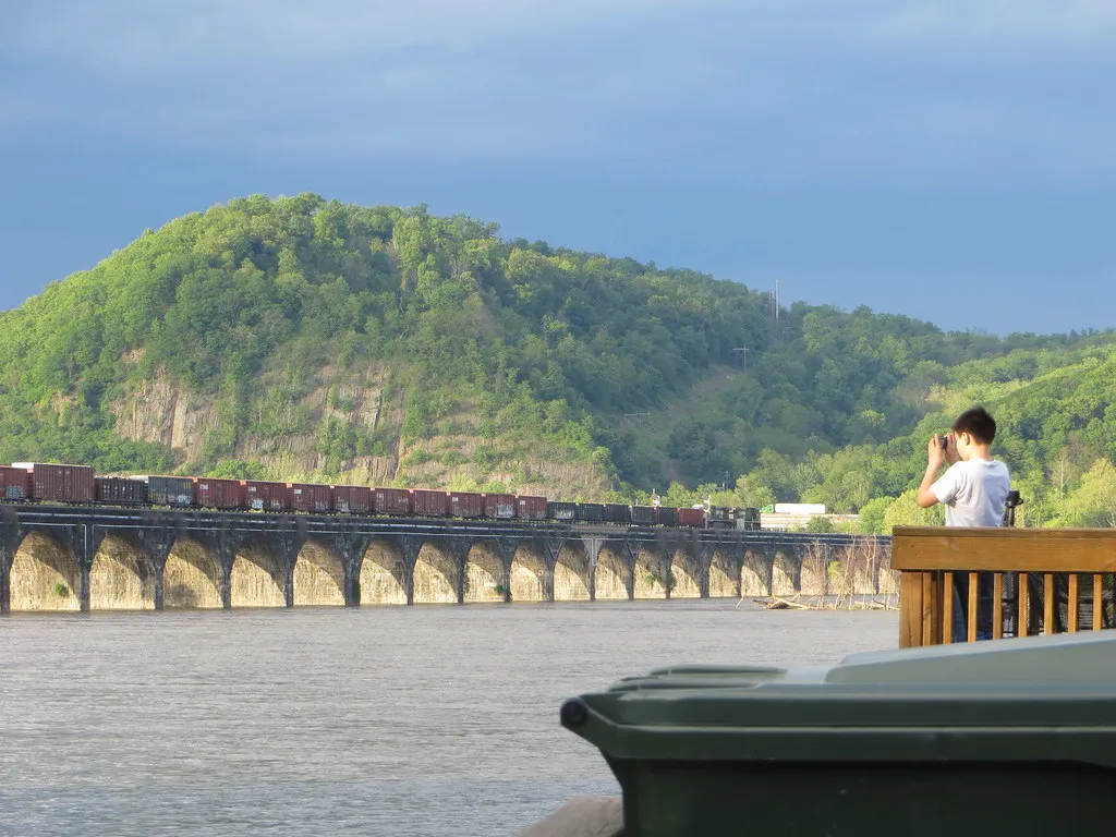
Rockville Bridge is one of the premier trainspotting destinations in the eastern United States, combining the world's longest stone masonry arch railroad bridge with Norfolk Southern's busiest freight corridor. The primary viewing area is Fort Hunter Mansion & Park at 5300 N. Front Street in Harrisburg (Rockville), on the east bank of the Susquehanna. The park is free to enter, open dawn to dusk, and offers ample parking, restrooms, picnic pavilions, and porch swings overlooking the bridge. A historical marker at the park's southern end provides the closest and most panoramic bridge view.
From the west shore, the Bridgeview Bed & Breakfast at 810 S. Main Street in Marysville sits directly across from the bridge and caters specifically to railfans, with viewing decks and a sitting room with picture windows facing the river. The boat launch south of the bridge on the Marysville side offers another public access point for photography.
The bridge currently carries two active main-line tracks (reduced from the original four). Control points CP Rockville and CP Wye mark the east approaches, while CP Mary and CP Hip control the west end. Trains approach at moderate speed due to the bridge's curvature, giving ample time to set up shots. Scanner frequencies for NS Harrisburg Division road channel are 160.800 MHz and 161.070 MHz.
Landscape, Setting & Local Atmosphere
The Susquehanna River stretches nearly half a mile wide at the Rockville crossing, flowing between low floodplain banks lined with sycamores and hardwoods. Blue Mountain of the Allegheny Range rises to the north behind the bridge, providing a layered backdrop that catches warm light during golden hour.
Fort Hunter Park sits on a 40-acre bluff on the east bank, originally settled in 1725 and featuring ten historic buildings listed on the National Register of Historic Places, including the 1815 Fort Hunter Mansion. The park's old Pennsylvania Canal towpath runs along the river, offering a walking trail with continuous bridge views. The Capital Area Greenbelt now connects Fort Hunter to Wildwood Park, a 229-acre nature preserve about 2 miles south.
Seasonal conditions vary dramatically: spring floods can raise the Susquehanna to lap at the lower arch stones, while autumn brings brilliant foliage on Blue Mountain. Winter strips the deciduous trees bare, opening cleaner sightlines to the bridge's full 3,820-foot span. In high wind events, Norfolk Southern has been known to park heavy trains on the bridge as wind shields — an unusual operational measure unique to this location.
Type & Frequency of Train Activity
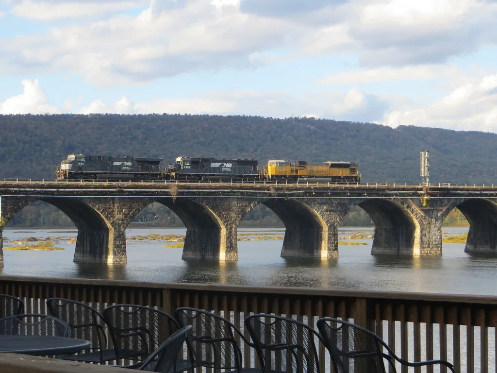
Rockville Bridge carries Norfolk Southern's Pittsburgh Line, the railroad's primary east-west freight artery connecting the Port of New York/New Jersey with Pittsburgh, Chicago, and the Midwest. Wikipedia and multiple railfan sources describe this as NS's busiest freight corridor, with 50 to 70 trains traversing the line daily.
Traffic includes intermodal double-stacks, manifest mixed freight (autos, chemicals, steel, grain), unit coal and coke trains from Appalachian mines, and unit crude oil and ethanol trains. Distributed power units (DPU) are common on heavier westbound consists headed for the Allegheny grade. Typical motive power includes GE ES44AC and ET44AC units, plus EMD SD70ACe variants.
On the east side of the bridge, the Pittsburgh Line connects with the Buffalo Line (formerly the Northern Central Railway route) heading north toward Sunbury and Williamsport via a wye junction. The Enola Yard complex — once the largest on the Pennsylvania Railroad system — lies just south of the bridge on the west bank and generates local switching moves.
Amtrak's Pennsylvanian (Train 42/43) makes one daily round trip between New York Penn Station and Pittsburgh, crossing Rockville Bridge in each direction. This is the only scheduled passenger service on the bridge.
Best Angles for Photos & What Railfans Enjoy Most
The east shore at Fort Hunter Park is the most popular photography location. The historical marker at the park's south end provides a side-on panorama showing all 48 arches, ideal with morning light (facing roughly west-southwest). A 24-70mm zoom captures the full bridge; a 70-200mm isolates individual arch bays with trains crossing. Reflections in calm water at dawn are possible from the shoreline trail south of the main park area.
From the west shore in Marysville, the Bridgeview B&B property and the boat launch offer head-on and three-quarter angles of trains emerging from the bridge's gentle curve. Sunset backlighting from this side can silhouette trains against orange skies. The Bridgeview B&B's wraparound deck and upper-level viewing areas (accessible to guests) are highly regarded for elevated angles.
For telephoto compression of multiple arches with a train, stand north of the bridge on the east shore near the Fort Hunter boat launch. Focal lengths of 200-300mm work well to stack arches and compress the perspective. GPS coordinates for the east end of the bridge: approximately 40.3425, -76.9295.
Winter photography benefits from bare deciduous trees revealing the full bridge structure. Spring river fog occasionally wraps the lower arches, creating atmospheric conditions. The bridge runs roughly east-west, so light direction shifts significantly between morning and evening sessions.
Historical or Cultural Relevance
Rockville Bridge was built between April 14, 1900 and its opening on March 30, 1902 by the Pennsylvania Railroad under President Alexander J. Cassatt and Chief Engineer William H. Brown. The project was part of the PRR's systematic program to replace aging iron and wooden bridges with permanent stone structures across its main line.
The bridge is the third at this site: a single-track wooden Howe truss opened September 1, 1849, followed by a double-track iron truss in 1877. The current structure features 48 seventy-foot sandstone arches spanning 3,820 feet total, at 52 feet wide — originally accommodating four main-line tracks. Construction required over 800 workers, including 300 Italian stonemasons, working for two Philadelphia contractors: Drake & Stratton (east half) and H.S. Kerbaugh, Inc. (west half). They used approximately 220,000 tons of sandstone quarried from Curwensville in Clearfield County and 150,000 cubic yards of concrete, at a total cost of about $1 million (approximately $37 million in today's dollars).
The bridge was listed on the National Register of Historic Places in 1975 (NRIS #75001640) and designated a National Historic Civil Engineering Landmark by ASCE in 1979. It was guarded by armed sentries during both World Wars as a strategic military target, and survived major floods in 1936, Hurricane Agnes in 1972, and the December 2010 blizzard. In 1997, a spandrel wall failure at pier 19 caused four coal hoppers to plunge into the river, requiring a $100 million repair and environmental cleanup. The bridge was subsequently repaired with reinforced concrete faced to match the original stonework.
The Library of Congress Historic American Engineering Record has documented the bridge (HAER PA-524).
What Makes This Spot Different
Rockville Bridge holds a distinction no other trainspotting location can claim: it is the longest stone masonry arch railroad viaduct ever constructed, and it carries one of the highest-volume freight corridors in the eastern United States. This combination of monumental 19th-century engineering and intense 21st-century rail operations is unique.
The bridge's accessibility sets it apart from many famous railfan destinations. Fort Hunter Park on the east shore is a free public park with parking, restrooms, picnic facilities, and maintained trails — all within clear view of the bridge. On the west shore, the Bridgeview Bed & Breakfast is one of the few railfan-oriented B&Bs in the country, purpose-built for watching trains cross the bridge from its riverside decks.
Wind events create a distinctive operational feature: in high winds, Norfolk Southern parks loaded trains on the bridge to act as wind barriers, preventing lighter cars from being blown into the river — a practice that has been necessary multiple times, including during the December 2010 blizzard when an intermodal container was blown off a train and into the Susquehanna.
The bridge's proximity to Harrisburg (just 5 miles north of downtown and the state capitol) and its position at the junction of the Pittsburgh Line and Buffalo Line make it both a destination and a convenient stop on longer railfan trips along NS's eastern network.
Frequently Asked Questions
QHow many trains cross Rockville Bridge per day?
Norfolk Southern's Pittsburgh Line carries 50 to 70 freight trains daily, plus one Amtrak Pennsylvanian round trip (Train 42/43 between New York and Pittsburgh). This makes it one of the busiest freight corridors in the eastern United States.
QWhere is the best place to view and photograph Rockville Bridge?
Fort Hunter Mansion & Park (5300 N. Front St, Harrisburg) on the east shore offers the most panoramic public views, with free parking, restrooms, and picnic areas. The historical marker at the park's south end has the closest view. On the west shore, the Bridgeview Bed & Breakfast in Marysville offers trackside viewing decks for guests.
QHow long is Rockville Bridge?
The bridge is 3,820 feet (1,160 meters) long with 48 stone arches, each spanning 70 feet. It is 52 feet wide. Built in 1902 by the Pennsylvania Railroad, it remains the longest stone masonry arch railroad viaduct in the world.
QCan you walk across Rockville Bridge?
No. The bridge is an active Norfolk Southern railroad bridge carrying heavy freight and Amtrak passenger trains. All railroad property, including the bridge and tracks, is strictly off-limits to pedestrians. Trespassing is enforced. View the bridge from Fort Hunter Park or other public areas.
QWhat scanner frequencies should I use at Rockville Bridge?
Norfolk Southern Harrisburg Division road channels: 160.800 MHz and 161.070 MHz. The Enola Branch uses 160.980 MHz between CP 111-L and CP Mary, and 161.445 MHz between CP Day and CP 111-L.
Safety Tips
The bridge and all railroad right-of-way are Norfolk Southern property. Do NOT trespass on the tracks or bridge — NS actively enforces trespassing violations. All photography should be done from public areas: Fort Hunter Park (east shore), the public boat launch (west shore), or N. Front Street in Rockville. The Bridgeview B&B offers private access for guests from the west shore. Be cautious near the river, especially during spring high water and ice-out periods. The Susquehanna has strong currents and underwater hazards.
Seasonal Information
Spring (April-May) brings occasional river fog that wraps the lower arches, plus high water from snowmelt — dramatic but potentially limiting shoreline access. Summer offers long daylight hours and lush green foliage framing the bridge, though heat haze can soften telephoto shots. Autumn (October-November) is widely considered the best season: Blue Mountain's hardwood foliage creates a spectacular backdrop, temperatures are comfortable, and shorter days bring golden-hour light at more convenient times. Winter provides the cleanest sightlines with bare trees, plus occasional snow-dusted arches, though cold winds off the Susquehanna can be bitter.
Nearby Lodging
- Bridgeview Bed & Breakfast
Railfan-oriented B&B at 810 S. Main St, Marysville, directly overlooking Rockville Bridge. 10 suites with private baths, wraparound deck, and sitting room with bridge views. Breakfast included. Phone: (717) 957-2438.
- Quality Inn Enola - Harrisburg
Budget-friendly hotel in Enola, about 4 miles south of the bridge. Close to I-81 Exit 59.
- Homewood Suites by Hilton Harrisburg-West Hershey Area
Extended-stay hotel about 8 miles south, with full kitchens and complimentary breakfast. Good base for multi-day railfan trips.
- Americas Best Value Inn Marysville
Budget motel on the west shore in Marysville, close to the bridge and I-81/US 15.
Nearby Attractions
0.2 miles / 0.3 km
Historic 40-acre park on the east bank of the Susquehanna with ten buildings on the National Register, guided mansion tours (May-Dec), picnic pavilions, and the best public views of Rockville Bridge.
5 miles / 8 km
One of the largest Civil War museums in the U.S., with 17 galleries, 4,000+ artifacts, and 66,000 sq ft of exhibit space. Located in Reservoir Park in Harrisburg.
5 miles / 8 km
Harrisburg's landmark 1906 capitol building offers free guided tours showcasing its Renaissance Revival architecture, murals, and stained glass.
2 miles / 3.2 km
A 229-acre nature preserve with a 3-mile paved trail, elevated boardwalk, wetlands, and bird watching. Connected to Fort Hunter Park via the Capital Area Greenbelt.
5 miles / 8 km
Preserved PRR-era interlocking tower in downtown Harrisburg, open seasonally with railroad artifacts and operational history displays.
118 miles / 190 km
The famous PRR-era horseshoe curve near Altoona, about 2 hours west on the same Pittsburgh Line. A natural companion visit for Rockville Bridge railfans.
External Links
informative
informative
informative
tourism
commercial
Looking for more spots? Browse the complete list of train spotting locations.
Quick Information
Country
USA
Region
Pennsylvania
City
Marysville
Spot Type
Bridge/Overpass
Best Times
Train traffic runs 24/7. For photography, morning light from Fort Hunter Park (east shore) illuminates westbound trains. Sunset from the Marysville west shore or Bridgeview B&B creates golden backlight through the arches. Amtrak's Pennsylvanian typically passes in the afternoon.
Visit Duration
2-4 hours (trains pass frequently enough that you'll see multiple in any 30-minute window)
Cost
Free. Fort Hunter Park has no admission fee. Parking is free.
Train Activity
Train Types
Frequency
50-70 freight trains per day on Norfolk Southern's Pittsburgh Line, plus one Amtrak Pennsylvanian round trip daily
Access & Amenities
Parking
Available (Free parking at Fort Hunter Park (east shore) and public boat launch areas)
Shelter
Available
Restrooms
Available