
Sullivan's Curve
One of the most iconic railfan locations on BNSF's Southern Transcon. Sullivan's Curve offers close-up views of 90+ daily BNSF and UP trains climbing Cajon Pass at the 2.2% grade, with the dramatic Mormon Rocks as backdrop.
Photos
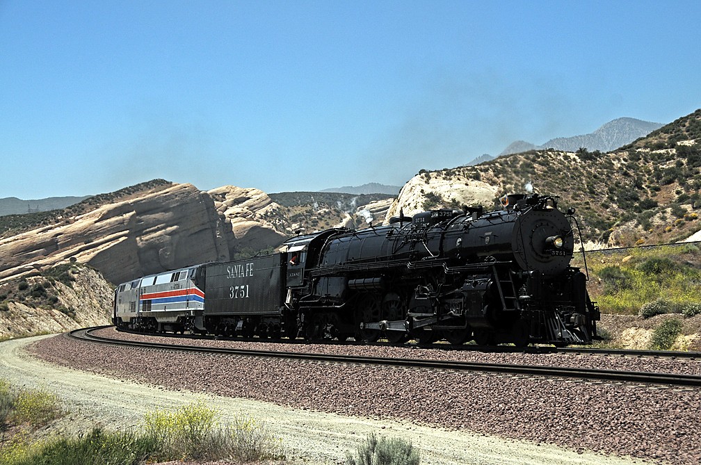
![]() drewj1946
drewj1946
4
Trainspotting Experience
Sullivan's Curve places you at railhead level on the inside of a sweeping curve on the BNSF Cajon Subdivision, roughly at milepost 62-63. From the elevated dirt turnout off a USFS road accessible via Lone Pine Canyon Road (off Highway 138), you look directly into the curve as trains swing past. Eastbound trains climbing the 2.2% grade ascend at 14-22 mph, giving you extended time to study power consists, read reporting marks, and spot distributed power units (DPUs) mid-train. Westbound trains descend at 20-30 mph with dynamic brakes engaged, producing that distinctive whine that carries across the desert air.
The BNSF three-main-track corridor and UP's parallel Palmdale Cutoff line are all visible from here, making train meets and overtakes a regular occurrence. Over a mile of train can be in view at once as consists stretch through the curve. Horn use is heavy due to nearby grade crossings. At dawn, the curve fills with the rumble of locomotives straining against the grade, and during peak periods you rarely wait more than 15-20 minutes between trains.
A railroad scanner is essential here — tune to BNSF road channel 161.190 MHz (AAR 72) for San Bernardino to Hodge traffic, and UP 160.740 MHz (AAR 42) for Colton to Hiland. BNSF and UP dispatchers work from a joint facility in San Bernardino, opened in 2009.
Landscape, Setting & Local Atmosphere
Sullivan's Curve sits at approximately 3,300 feet elevation on the desert side of Cajon Pass, where the San Gabriel Mountains meet the San Bernardino Mountains along the San Andreas Fault. The fault itself is responsible for the area's dramatic geology, including the nearby Mormon Rocks — tilted sandstone formations pushed up by tectonic movement, named after the 1851 Mormon settlers led by Amasa Lyman and Charles Rich who camped here on their wagon journey from Salt Lake City.
The surrounding terrain is a mix of chaparral, scattered Joshua trees, and pinyon pines clinging to slopes of decomposed granite and exposed red sandstone. To the east, the Mojave Desert opens out beyond Victor Valley; to the west, the flanks of the San Gabriels rise steeply. Interstate 15 runs above and parallel but is mostly out of direct sightline from the curve.
Summers are hot (90°F+) but typically breezy, and the dry desert air keeps visibility excellent. Winter can bring occasional snow dustings on the surrounding peaks — even rare snow at track level — and temperatures drop sharply after sunset. The Pacific Crest Trail passes through the area, and hikers can sometimes be seen crossing the BNSF mainline at the designated PCT crossing near Highway 138.
Type & Frequency of Train Activity
Cajon Pass is among the busiest mountain rail corridors in the United States, and Sullivan's Curve captures nearly the full show. According to Trains Magazine's detailed Cajon Pass guide, typical daily traffic averages approximately 90 trains per 24-hour period:
BNSF Railway operates an average of 70 trains daily on the three-main-track Cajon Subdivision (part of the Southern Transcon corridor linking Chicago to Los Angeles). Traffic is dominated by double-stacked intermodal containers, domestic trailer-on-flatcar, unit grain, auto racks, and manifest freight. Premium Z-trains (expedited intermodal) are common.
Union Pacific averages about 20 trains daily using both its own single-track Palmdale Cutoff (the former Southern Pacific line, opened July 11, 1967) and BNSF trackage rights through the pass. UP traffic includes intermodal, manifest, and military movements from the nearby Marine Corps Logistics Base in Barstow.
Amtrak's Southwest Chief (trains 3 and 4) passes once in each direction daily on the BNSF line, typically in early morning and late evening. This is the lone regular passenger train since the Desert Wind was discontinued in 1997.
BNSF ended regular manned helper service on Cajon Pass in October 2009; distributed power is now standard. UP still maintains one helper pool. With the third main track (completed 2008), BNSF's theoretical capacity through the pass is 150 trains per day.
Best Angles for Photos & What Railfans Enjoy Most
The classic Sullivan's Curve shot is from the inside of the bend, looking northwest, where the three BNSF main tracks create layered leading lines curving toward distant ridges. The Mormon Rocks formation (34°19'06"N 117°29'31"W) provides an iconic backdrop in the middle distance.
Morning (sunrise to ~10am): East-facing light illuminates locomotive noses as trains round the curve toward you. This is the "money shot" window — the February 2025 Justin Franz Substack trip report describes scoring his best photos at dawn. A 200-400mm telephoto compresses the curve and stacks the trains dramatically against the sandstone.
Late afternoon (3-6pm): Side-lighting paints warm color onto train flanks while the mountains darken for contrast. Excellent for showing the full length of consists.
Wide-angle (24-35mm): Include sky, sandstone formations, and the sweeping curve in a single environmental frame. Works well from the higher ground above the turnout, where a short scramble up the adjacent slope reveals the full curve plus the parallel UP Palmdale Cutoff on the opposite hillside — ideal for capturing train meets across railroads.
Night photography is popular here: long exposures capture headlight trails snaking through the curve. Tripod essential; the dark desert sky and absence of light pollution help. Compass orientation runs roughly NW-SE through the curve.
Historical or Cultural Relevance
Sullivan's Curve takes its name from Herb Sullivan, a rancher and amateur photographer from Placentia, California, who came here in the 1930s and 1940s to photograph Atchison, Topeka & Santa Fe and Union Pacific steam locomotives rounding the curve. His published images — many used in Santa Fe promotional materials and featured in Trains Magazine — made the location famous among railfans and earned it its enduring name. The curve also became the subject of oil paintings by artists including John Winfield and Andrew Harmantas.
The curve sits on the 1913 second mainline alignment, built to accommodate growing traffic with a more manageable 2.2% grade (versus the original 1885 line's steeper 3% grade). This second track featured two short tunnels, both later "daylighted" (removed) during modernization. In 1972, the Santa Fe completed a major project reducing curvature from 10 degrees to 4 degrees at the summit. In the 1970s, a massive cut was excavated alongside the original main line near Summit to create a straighter alignment.
Other key milestones: Southern Pacific opened its 78-mile Palmdale Cutoff in 1967, breaking the Santa Fe's monopoly on Cajon. BNSF completed its $90 million third main track through the pass in 2008, adding 5.9 miles of new track and boosting capacity from ~100 to 150 trains per day. The pass has also been the site of several notable accidents, including the 1989 SP runaway that caused the San Bernardino train disaster, and a dramatic 1994 head-on between Santa Fe and UP trains near Highway 138.
What Makes This Spot Different
Sullivan's Curve puts you at railhead level, closer to the action than the elevated panoramic views at nearby Hill 582 (where railfans have planted trees and set up benches over the decades) or the flat-side perspectives at Blue Cut further down the pass. This proximity means you feel the ballast vibrate underfoot, hear the dynamic brakes biting, and can read individual car numbers without binoculars.
The combination of tight curvature, three BNSF main tracks plus the adjacent UP Palmdale Cutoff, and the rugged mountain setting means you can photograph nose-to-tail action from a single position with over 180 degrees of unobstructed sightlines. It is common to see BNSF trains on all three mains simultaneously, or a BNSF/UP "meet" across the parallel corridors.
Few railfan locations anywhere offer two Class I railroads, a 2.2% mountain grade, 90+ daily trains, year-round access in Southern California weather, and an iconic named location recognized worldwide in the railfan community. As BNSF's own railfan photography guide notes, this is "a must for many rail photographers."
Frequently Asked Questions
QHow many trains pass Sullivan's Curve per day?
Approximately 90 trains per 24-hour period: BNSF averages about 70 daily trains, Union Pacific adds roughly 20, and Amtrak's Southwest Chief passes twice daily (once each direction). You rarely wait more than 15-20 minutes between trains during daylight hours.
QHow do I get to Sullivan's Curve?
From I-15, take the Highway 138 exit. Turn onto Lone Pine Canyon Road and look for a USFS road (left turn) that parallels the former SP Palmdale Cutoff back to the curve. Alternatively, access via Cajon Blvd (old Route 66) to Swarthout Canyon Road. The road is unpaved but passable for most vehicles in dry conditions. GPS coordinates: approximately 34.298°N, 117.472°W.
QWhat radio frequencies should I monitor?
BNSF Cajon Subdivision road channel: 161.190 MHz (AAR 72) from San Bernardino to Hodge. Union Pacific: 160.740 MHz (AAR 42) from Colton to Hiland. Both railroads are dispatched from a joint facility in San Bernardino opened in 2009.
QWho was Sullivan's Curve named after?
Herb Sullivan, a rancher and amateur photographer from Placentia, California, who photographed Santa Fe and Union Pacific steam locomotives at this curve during the 1930s and 1940s. His images were widely published in Trains Magazine and used in Santa Fe promotional materials.
QIs Sullivan's Curve on public or private land?
The viewing areas are accessible via U.S. Forest Service roads within the San Bernardino National Forest. The railroad right-of-way itself is private property — stay off the tracks and respect railroad police. BNSF and UP both enforce trespassing laws in the pass.
Safety Tips
Stay off railroad property and tracks at all times — both BNSF and UP employ railroad police in the Cajon Pass area. The USFS roads provide legal access to viewing areas, but the railroad right-of-way itself is strictly off-limits. Trains here are quiet until suddenly close due to the curving terrain, and consists travelling at 20-30 mph downgrade approach faster than expected. The area is within the San Bernardino National Forest; a USFS Motor Vehicle Use Map is useful for identifying legal access roads. Rattlesnakes are present in the desert terrain, particularly in warm months. Cell phone coverage is spotty in the pass — let someone know your plans. No facilities (restrooms, water, shade) exist at the curve itself.
Seasonal Information
Sullivan's Curve offers year-round trainwatching thanks to Southern California's dry climate. Summer (June-September) is hot — temperatures at 3,300 ft regularly exceed 90°F — so bring sun protection, water, and consider early morning visits. Spring and fall provide the most comfortable conditions with mild temperatures and clear skies. Winter occasionally brings snow to the surrounding peaks and rarely to track level; cold mornings transition to pleasant afternoons. Wildflowers (lupine, bush poppies) bloom March through May on the surrounding hillsides.
Nearby Lodging
- Cajon Pass Inn (Best Western)
Located at the junction of Highway 138 and I-15, just 1 mile from the Pacific Crest Trail. Seasonal outdoor pool, hot tub, complimentary breakfast. The closest hotel to Sullivan's Curve.
- Holiday Inn Express Hotel & Suites Hesperia
Off I-15 in Hesperia, less than 15 minutes from the pass. Indoor pool, gym, free Wi-Fi. Good base for multi-day Cajon Pass visits.
- Courtyard by Marriott Victorville Hesperia
Mid-range hotel in Hesperia with restaurant, bar, outdoor and indoor pools. About 20 minutes from Sullivan's Curve via I-15.
- Motel 6 Hesperia
Budget option off I-15 in Hesperia with outdoor pool and basic amenities. Practical for railfans prioritizing early morning starts.
Nearby Attractions
0.9 miles / 1.5 km
Dramatic tilted sandstone formations pushed up by the San Andreas Fault, named after the 1851 Mormon settlers. A one-mile interpretive loop trail starts from the fire station off Highway 138. Visible from Sullivan's Curve.
3.1 miles / 5 km
Elevated railfan viewpoint with wide-angle views of all three BNSF main tracks and the UP Palmdale Cutoff. Railfans have planted trees and added benches over the years. Accessible via Summit Valley Road off Highway 138.
10 miles / 16 km
Mountain reservoir offering fishing, boating, swimming, hiking, and camping. Beautiful views of surrounding San Bernardino Mountains. Located northeast of Cajon Pass off Highway 138.
0.6 miles / 1 km
The famous 2,650-mile PCT crosses through Cajon Pass, intersecting the BNSF mainline near Highway 138. The trail section here is one of the hottest and most grueling for thru-hikers.
1.2 miles / 2 km
Well-preserved fragment of old Route 66 (now Cajon Boulevard) runs parallel to the railroad through the pass. Accessible via Kenwood Avenue or Cleghorn Road exits off I-15.
External Links
informative
informative
informative
informative
Looking for more spots? Browse the complete list of train spotting locations.
Quick Information
Country
USA
Region
California
City
Hesperia
Spot Type
Curve/Loop
Best Times
Dawn to mid-morning for best lighting on eastbound locomotive faces; late afternoon (3-6 PM) for side-lit train flanks. Trains run 24/7 but peak activity often occurs in late afternoon and overnight. The Southwest Chief passes in early morning and late evening.
Visit Duration
2-4 hours (minimum 1 hour — trains come frequently)
Cost
Free
Train Activity
Train Types
Frequency
Approximately 90 trains per 24-hour period: BNSF averages ~70/day, UP ~20/day, plus Amtrak Southwest Chief twice daily (source: Trains Magazine Cajon Pass guide)
Access & Amenities
Parking
Available (Free — informal dirt pullouts along USFS roads)
Shelter
Not available
Restrooms
Not available