
White Pass (WP&YR)
The White Pass & Yukon Route climbs 2,888 feet in 20 miles on 3-foot narrow-gauge track to the summit at Mile 20.4, crossing the 215-foot steel cantilever bridge over Dead Horse Gulch — one of the most dramatic heritage railway alignments in North America.
Photos
![]() jurvetson
jurvetson
Attribution License
Trainspotting Experience
Watching WP&YR trains conquer White Pass is unlike anything on North American mainlines. The railway climbs 2,888 feet in just 20 miles on grades reaching 3.9% and curves up to 16 degrees — steep enough that locomotives labor visibly at 15 mph. Consists typically feature two GE shovelnose diesel units (Nos. 90–100) or MLW ALCO DL-535E units (Nos. 101–110) on the head end, with 12–15 restored passenger cars.
The summit area (elevation 2,888 ft, Mile 20.4) sits on the Alaska-Canada border where the Klondike Highway runs adjacent to the tracks, giving independent observers their best chance to watch trains reverse direction before descending. The roadside shoulder near the summit monument provides an elevated vantage for both northbound and southbound moves. Allow time: trains pause briefly for customs formalities at the border.
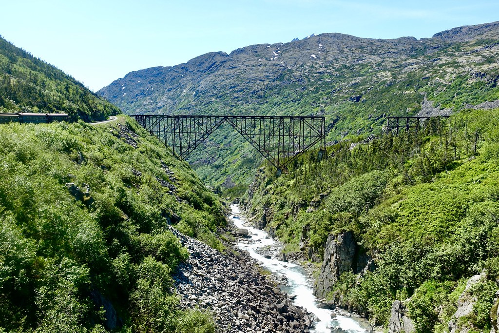
Below the summit, the steel cantilever bridge over Dead Horse Gulch (215 feet above the gorge floor) is the most dramatic single-span feature on the route — visible from both the highway and dedicated viewpoints. Drone flight is restricted within the U.S. Customs zone at the international boundary.
Landscape, Setting & Local Atmosphere
White Pass is a windswept mountain saddle on the Alaska-Canada border at 2,888 feet elevation. At the summit, the coastal rainforest of sea-level Skagway gives way to sub-alpine tundra — stunted spruce, heath, and lichen-covered granite outcrops. Snow patches persist well into July, and summer temperatures at the summit rarely exceed the mid-50s °F even on clear days.
The dominant feature for photographers is the transition from fjord-facing granite cliffs below to open ridge terrain at the summit. Dead Horse Gulch — named for the estimated 3,000 pack animals that died during the 1897–98 Gold Rush stampede — is flanked by steep talus slopes and a 215-foot-deep gorge crossed by the WP&YR cantilever bridge. Looking south from the summit, the drop toward tidewater at Skagway is visible on clear days: nearly 2,900 feet of relief in under 20 miles of horizontal distance.
Weather at the summit is unpredictable even in July: bring layers, waterproofs, and account for gusts strong enough to affect a telephoto lens on a lightweight tripod.
Type & Frequency of Train Activity
WP&YR operates as a seasonal heritage passenger carrier from early May through late September. Departures from Skagway are at 8:15 AM and 12:45 PM daily, with a third departure at 4:30 PM on Tuesdays and Wednesdays from late May through late August — schedules timed to coincide with cruise-ship docking windows at Skagway harbor.
Motive power comes from three generations of narrow-gauge diesel-electrics: the original GE shovelnose units (Nos. 90–100, built 1954–1966 with ALCO 6-251B prime movers), the MLW ALCO DL-535E units (Nos. 101–110, delivered 1969–1971), and, for special excursions, steam No. 73 (1947 Baldwin 2-8-2 Mikado) or No. 69 (1908 Baldwin 2-8-0 Consolidation, restored 2008). The 3-foot gauge means passenger cars are just 8 feet wide — a distinctively slender silhouette against the mountain backdrop.
Off-season, the line enters winter hibernation. Snow regularly buries the rails above approximately 1,500 feet, and no scheduled service runs between October and April.
Best Angles for Photos & What Railfans Enjoy Most
The summit area (Mile 20.4, near the Alaska-Canada boundary monument) offers the most accessible independent photo opportunities: trains approaching from below appear against the open ridge before reversing direction. A 200mm telephoto compresses the mountain backdrop effectively; a 400mm lens brings distant curves close. The 12:45 PM departure from Skagway typically crests the summit between 2–3 PM, offering diffuse light suited to overcast mountain conditions.
The steel cantilever bridge over Dead Horse Gulch is visible from a designated pullout on the Klondike Highway. A 70–200mm lens from this position captures the full train spanning the 215-foot gorge with talus slopes and glaciers in the distance. Southbound (morning) trains receive direct light on the west-facing bridge span; northbound afternoon trains are backlit against the peaks.
Bridal Veil Falls at MP 11.5 — with up to 22 cataracts visible — is best photographed from on-board the 8:15 AM departure, when the east-facing falls receive direct morning light. Drone use is prohibited within the U.S. Customs zone at the summit border. A stable tripod is essential given summit winds.
Historical or Cultural Relevance
Construction began in May 1898 and was completed July 29, 1900 — 110 miles of 3-foot narrow-gauge track blasted through coastal mountains in 26 months at a cost of approximately $10 million, using British financing, American engineering, and Canadian contracting. Tens of thousands of workers and an estimated 450 tons of explosives were required to breach the mountain barrier between tidewater Skagway and the Yukon interior.
The WP&YR is recognized as an International Historic Civil Engineering Landmark — a distinction shared with the Panama Canal, the Eiffel Tower, and the Statue of Liberty. The steel cantilever bridge at Dead Horse Gulch, spanning 215 feet above the gorge, was the tallest of its kind in the world when completed in 1901. The line climbs nearly 2,900 feet in 20 miles with grades to 3.9% and curves to 16 degrees — features at the practical limits of railway engineering in 1898.
Freight operations (primarily lead-zinc concentrate from Yukon mines) continued until 1982, when depressed metal prices forced closure. Heritage tourism operations resumed in 1988 and have run continuously since, with many original stone retaining walls, snow sheds, and trestles still visible along the route.
What Makes This Spot Different
WP&YR is one of the few narrow-gauge railways in North America operating steam on a regular seasonal basis. Both No. 73 (1947 Baldwin 2-8-2 Mikado) and No. 69 (1908 Baldwin 2-8-0, restored 2008) run in commercial excursion service. The 3-foot gauge combined with 3.9% grades and 16-degree curves produces visible locomotive effort — wheel flanges squeal audibly on tight rail and diesel exhaust plumes at full throttle drift across the valley.
Unlike most heritage railways, WP&YR runs at genuine commercial scale: up to 3 round trips daily in peak season means multiple passes per hour from fixed viewpoints. The Dead Horse Gulch cantilever bridge, soaring 215 feet above the gorge, can only be properly photographed from the railway car or the Klondike Highway pullout above. The 1898 alignment has never been moved or realigned — every curve, trestle, and retaining wall dates to the original construction.
Frequently Asked Questions
QIs White Pass accessible year-round for trainspotting?
No. WP&YR operates from early May through late September only. Outside this window, the railway enters winter hibernation. Tracks above approximately 1,500 feet are buried under snow from October through April. The summit area remains accessible by car via the Klondike Highway year-round, but no trains run.
QWhat locomotives power WP&YR trains?
The railway uses GE shovelnose diesel-electric units (Nos. 90–100, built 1954–1966) and MLW ALCO DL-535E units (Nos. 101–110, delivered 1969–1971). Steam excursions use No. 73 (1947 Baldwin 2-8-2 Mikado) or No. 69 (1908 Baldwin 2-8-0 Consolidation, restored 2008). Consists typically run 12–15 restored narrow-gauge passenger cars.
QHow many trains per day can I see at White Pass?
During peak season, trains depart Skagway at 8:15 AM and 12:45 PM daily, with a third at 4:30 PM on Tuesdays and Wednesdays from late May through late August. From a summit viewpoint, expect 2–3 northbound passes per day, each followed by a southbound return approximately 30 minutes later.
QCan I watch the trains without buying a ticket?
Yes. The White Pass summit sits on the Alaska-Canada border alongside the Klondike Highway. Independent observers can watch from roadside pullouts near the summit monument and from the Dead Horse Gulch highway overlook, without purchasing a train ticket.
QAre drones allowed for photography at White Pass?
Drone operation is restricted within the U.S. Customs Zone at the international boundary. Check FAA and Transport Canada regulations before flying — unauthorized flights in the border zone are prohibited. Ground-based photography from highway positions is unrestricted.
QHow steep is the railway and what elevation does it reach?
The WP&YR gains 2,888 feet in just 20 miles — grades reach 3.9% and curves reach 16 degrees, among the steepest operated by any scheduled passenger railway in North America. The summit at Mile 20.4 sits on the Alaska-Canada border. The Dead Horse Gulch cantilever bridge soars 215 feet above the gorge floor.
Safety Tips
Stay well clear of the railway right-of-way — shoulders are narrow with rock faces on one side and steep drop-offs on the other. At the summit, weather changes rapidly even in summer; carry layers and rain gear at all times. The Dead Horse Gulch overlook is on a Klondike Highway shoulder — remain alert to vehicle traffic. The summit crosses into Canada; carry valid identification and be prepared for Canada Border Services Agency interaction if crossing the boundary.
Seasonal Information
WP&YR operates exclusively between early May and late September. June through August offers maximum frequency (up to 3 daily departures), 18+ hours of daylight near the summer solstice, and the most reliable weather window at the summit. The summit in late May and early June still carries significant snowpack, and Bridal Veil Falls (MP 11.5) runs at maximum volume from snowmelt. September brings early autumn color to the sub-alpine zone and reduced crowds, though departures thin to 1–2 per day. Outside the operating window, White Pass is accessible by road year-round, but the railway is silent and tracks are buried under heavy snow above approximately 1,500 feet.
Nearby Lodging
- Morning Wood Hotel
Downtown Skagway property steps from Broadway and a short 5-minute walk to the WP&YR station, ferry terminal, and airport. Rates from approximately $125/night.
- Historic Skagway Inn
Victorian bed and breakfast in an 1897 Gold Rush-era building in the historic district, within walking distance of the WP&YR station. Offers free shuttle service and luggage storage.
- Sgt. Preston's Lodge
Centrally located hotel in downtown Skagway within easy walking distance of the WP&YR depot and the Klondike Gold Rush National Historical Park visitor center.
- At the White House
Historic 1902 building modernized with contemporary amenities while retaining its Gold Rush-era character, located 2 blocks from the WP&YR station in the heart of the historic district.
Nearby Attractions
0.2 miles / 0.3 km
Housed in the original 1898 WP&YR depot building, this NPS site offers ranger-led walking tours and screens the 25-minute film "Gold Fever: Race to the Klondike." The visitor center covers both the Chilkoot and White Pass routes with exhibits on the Gold Rush era.
0.3 miles / 0.5 km
Located in Skagway City Hall — the first stone building in Alaska (1899) — this museum displays a WP&YR locomotive and caboose, Gold Rush tools and supplies, Tlingit canoes, Bering Sea kayaks, and a collection of Alaska Native beadwork and carvings.
0.2 miles / 0.4 km
Built in 1899 and covered with nearly 9,000 driftwood sticks collected from Skagway Bay, this fraternal hall is often called the most photographed building in Alaska. Now home to the Skagway Convention & Visitors Bureau.
8.7 miles / 14 km
A Klondike Highway pullout offering views of the WP&YR steel cantilever bridge soaring 215 feet above the gorge — named for the estimated 3,000 pack animals that perished here during the 1897–98 Gold Rush. The best roadside vantage for photographing trains on the bridge.
13.7 miles / 22 km
A US Forest Service backcountry cabin accessible exclusively by WP&YR whistle-stop train service, approximately 14 miles from Skagway. The cabin sits in the Skagway River valley with views of Laughton Glacier — a unique overnight option combining rail travel and wilderness.
External Links
Informative
Tourism
informative
informative
official
informative
informative
Looking for more spots? Browse the complete list of train spotting locations.
Quick Information
Country
USA
Region
Alaska
City
Skagway
Spot Type
Scenic Overlook
Best Times
8:15 AM departure from Skagway reaches White Pass summit roughly 10–11 AM for morning light. The 12:45 PM train crests the summit around 2–3 PM — suitable for overcast conditions. Steam excursions, when scheduled, typically run on the morning departure.
Visit Duration
2–3 hours at the summit viewpoint. Allow 3.5–4 hours if driving round-trip from Skagway (approximately 45 minutes each way via the Klondike Highway). Train passengers: 2.5–3 hours round trip for the Summit Excursion.
Cost
Free to observe from summit roadside pullouts and the Dead Horse Gulch highway viewpoint. Train tickets for the Summit Excursion vary by season — check wpyr.com for current pricing.
Train Activity
Train Types
Frequency
2–3 round trips daily (May–September): 8:15 AM and 12:45 PM every day, plus 4:30 PM Tue–Wed from late May through late August
Access & Amenities
Parking
Available
Shelter
Not available
Restrooms
Not available