
Williams Loop (Feather River)
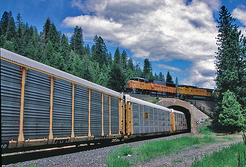
Williams Loop is a one-mile rail spiral on Union Pacific's Feather River Route in Plumas County, where the track crosses over itself to gain 65 feet of elevation on the 1% grade to Beckwourth Pass. Built in 1914 by the Western Pacific Railroad, it is one of North America's most photographed trainspotting sites — roadside pullouts along Highway 70 give an elevated view of an entire freight train encircling itself.
Photos
![]() Slideshow Bruce
Slideshow Bruce
4
Trainspotting Experience
From the highway pullouts and informal footpaths, visitors can look down on the entire loop and see a train from nose to caboose as it wraps around the hillside. Eastbounds grind uphill toward Portola; westbounds descend toward the trestles of the Feather River Canyon, dynamic brakes howling. Typical speeds hover between 25 and 35 mph because of the 10-degree curvature, so there is ample time to set up shots, note locomotive consists, and listen to the deep exhaust echoes bouncing off the canyon walls. A full loop transit lasts roughly 4–5 minutes for a standard 7,000-foot freight; monster drags top 10,000 feet and can occupy the scene for nearly ten minutes. The setting’s natural amphitheater accentuates every horn blast, flange squeal, and coupler clank, making the experience multisensory and immersive.
Landscape, Setting & Local Atmosphere
Perched around 4,800 feet above sea level, Williams Loop sits on a forested bench between the Middle Fork of the Feather River (far below) and the higher ridges leading to Beckwourth Pass. Ponderosa pine, incense cedar, and black oak dominate the slopes, while manzanita and wild lupine color the understory in spring. Summers bring warm, dry afternoons with crystal-clear mountain air, but evenings cool quickly. Autumn paints the oaks gold, and winter can blanket the rails in snow, adding dramatic contrast to photographs—though road access may be limited after storms. The distant hum of State Route 70 fades beneath the steady pulse of locomotives, leaving a surprisingly quiet, almost contemplative atmosphere between train movements.
Type & Frequency of Train Activity
The line is owned and dispatched by Union Pacific, successor to the Western Pacific. On most days 10–18 freight trains pass through, a mix of manifest, unit grain, empty and loaded coal, and high-priority intermodal blocks linking Northern California with Salt Lake City and beyond. Distributed-power mid-train and rear DPUs are common. BNSF Railway holds trackage rights and occasionally reroutes freights here when Needles or Donner Pass traffic is disrupted, adding variety for the patient spotter. Regular passenger service ended in the mid-1970s, but private charters and the Amtrak California Zephyr have detoured over the loop during maintenance windows on Donner Pass, so keeping an ear on railfan forums or ATCS feeds can deliver rare surprises.
Best Angles for Photos & What Railfans Enjoy Most
• Highway 70 pullout (west side): Elevated view to frame an entire eastbound train circling below, best lit from mid-morning until early afternoon.
• Hilltop rock outcrop (short scramble from old logging track): Perfect for capturing the head end emerging beneath the tail end directly above it—iconic “train on top of itself” shot. Afternoon light here silhouettes westbounds against the sky.
• South embankment meadow: Allows low-angle images of locomotives curving toward the viewer with conifers as backdrop; sunrise light is soft and even.
Telephoto lenses (200 mm+) compress the loop, emphasizing the stacked geometry, while wide-angles dramatize foreground pines and granite. Enthusiasts also enjoy audio recordings; the loop’s bowl shape amplifies engines so distinctly that sound files captured here are sought after for simulation software.
Historical or Cultural Relevance
Completed in 1914 as part of the Western Pacific’s strategy to maintain its trademark 1 percent ruling grade through the Sierra, Williams Loop raises the track about 65 feet in one circuit, eliminating the need for steeper, costlier switchbacks. Together with nearby Spring Garden Tunnel and the Keddie Wye, it showcases early 20th-century railroad engineering that prioritized gentle grades to compete with Southern Pacific’s steeper Donner Pass route. The line remained a vital freight artery during World War II, funneling supplies to the Pacific theater, and the loop itself has appeared in countless rail calendars and documentaries celebrating Western Pacific’s “Feather River Route.”
What Makes This Spot Different
While many mountain railfan sites offer dramatic scenery, few allow viewers to witness an entire long freight encircling itself in one uninterrupted panorama without hiking deep into wilderness. The loop’s proximity to a paved state highway and its moderate elevation (often snow-free when higher passes are closed) make it uniquely accessible year-round. Add the combination of steady traffic, mountain acoustics, and the engineering elegance of a pure 360-degree curve, and Williams Loop delivers a blend of convenience and spectacle that stands apart from more remote or linear canyon viewpoints.
Frequently Asked Questions
QWhere is the best place to view Williams Loop from Highway 70?
The most popular viewpoint is an informal pullout on Highway 70 on the west side of the loop, where you can look down and see the entire spiral — including the head end passing beneath the tail end of a long train. A short scramble up a logging track leads to a higher rock outcrop ideal for the iconic 'train crossing over itself' composition. The south embankment meadow offers low-angle morning shots with conifers as backdrop. There is no formal parking lot; use roadside pullouts carefully.
QHow many trains pass through Williams Loop each day?
Roughly 10–20 freight trains per day is a commonly cited estimate for this section of the Feather River Route. Union Pacific dispatches most trains; BNSF uses trackage rights and occasionally reroutes trains here when the Donner Pass corridor is congested. Daily counts can vary significantly — weekends and holiday periods often see more activity.
QIs Williams Loop accessible year-round?
Generally yes — at 4,800 feet elevation it is often passable when higher Sierra passes are closed. However, Highway 70 through the Feather River Canyon is subject to periodic closures from rockslides and flooding, especially November through April. Always check Caltrans District 2 road conditions at dot.ca.gov before driving.
QWhat railway operators run trains through Williams Loop?
Union Pacific is the primary operator, dispatching trains on the former Western Pacific main line. BNSF Railway holds trackage rights and runs occasional detour freights over the line when the Donner Pass or Southern Transcon routes are congested.
QWhat focal length works best for photographing the loop?
A telephoto lens (200–400mm equivalent) compresses the spiral geometry and emphasizes trains crossing over themselves — the signature shot here. Wide-angle lenses (24–50mm) work well from the meadow viewpoints when you want to include surrounding pines and canyon walls. Morning and late afternoon light is directional and warm; avoid midday when shadows fill the canyon.
Safety Tips
Stay well back from the active Union Pacific main line — the railroad right-of-way is private property. Viewpoints sit on or adjacent to Highway 70, a busy two-lane road through a narrow canyon; watch for traffic when crossing or standing on the shoulder. The informal scramble paths to higher viewpoints involve loose rock on steep terrain — wear proper footwear. Cell service is limited in the Feather River Canyon. Highway 70 is prone to sudden rockslides; do not park in slide-prone zones. Carry water as there are no facilities at the loop.
Seasonal Information
Late spring through early fall offers the most reliable access. Highway 70 through the Feather River Canyon is prone to rockslides, flooding, and storm damage that can close the road for days or weeks — always check Caltrans District 2 conditions before driving, especially November through April. At 4,800 feet elevation, snow falls from November through March; the loop area is often passable when higher Sierra passes (Donner at 7,057 ft) are already closed. Autumn brings spectacular black oak foliage and clear, cool air; October and early November light in the canyon is a favorite of rail photographers.
Nearby Lodging
- Quincy Feather Bed Inn
A charming boutique bed-and-breakfast in historic downtown Quincy, about 15 miles west of Williams Loop along Highway 70. Offers 5 rooms and 2 private-entrance cottages in a restored Victorian setting — the closest comfortable indoor accommodation to the loop.
- Feather River Canyon Cottage
A riverside cottage in Twain, California, situated directly in the Feather River Canyon along Highway 70. Sleeps 2, with fast Wi-Fi and access to the river, making it an ideal base for multi-day railfan trips to Williams Loop and surrounding canyon viewpoints.
- Gansner Bar Campground (Plumas National Forest)
A public campground on the Middle Fork of the Feather River, approximately 32 miles west of Williams Loop along Highway 70. A budget-friendly option for railfans doing a multi-day canyon trip, with riverside sites and proximity to multiple UP viewing spots.
- Knotty Pine Resort and Marina
A seasonal lakefront resort on Lake Almanor, south of Portola, offering cabins, a marina, restaurant, and RV park. Convenient for railfans combining a Williams Loop visit with time at the Western Pacific Railroad Museum in Portola (~18 miles east).
Nearby Attractions
18 miles / 29 km
The world's largest operating railroad museum dedicated to the Western Pacific, located in Portola. Visitors can explore over 100 pieces of historic rolling stock and, uniquely, pay to operate a real locomotive on the museum grounds through the "Run A Locomotive" program.
11 miles / 18 km
The only railroad wye junction in the world where two tracks merge over a canyon and enter a tunnel side by side. This Union Pacific engineering landmark sits about 11 miles west of Williams Loop along Highway 70 and is one of the "Seven Railroad Wonders of the Feather River Canyon."
20 miles / 32 km
A historic gold-rush-era park featuring a restored stamp mill, mine shafts, and a museum covering the region's 19th-century mining history. The park also offers hiking trails through alpine terrain with views of the Sierra Nevada.
The 130-mile Feather River Scenic Byway follows Highway 70 through Butte, Plumas, and Lassen counties, paralleling the active Union Pacific main line. The drive passes through the canyon alongside freight trains, historic trestles, and tunnels, making the road trip itself a railfan experience.
25 miles / 40 km
A high-Sierra recreation area with dozens of alpine lakes, hiking trails, and forest scenery, located north of Quincy. Popular for fishing, swimming, and camping during summer months, offering a natural complement to a railfan day trip in the canyon.
External Links
informative
Looking for more spots? Browse the complete list of train spotting locations.
Quick Information
Country
USA
Region
California
City
Spring Garden
Spot Type
Curve/Loop
Best Times
Morning through early afternoon for optimal east-facing light. Mid-morning (9 am–noon) catches westbound freights descending with dynamic brakes roaring; eastbound freights climbing toward Portola are slower and easier to compose. Late afternoon backlights trains against the Sierra Nevada skyline — better suited for silhouette shots. Traffic runs through the full 24-hour cycle; check ATCS Monitor or UP railfan forums for real-time consist information.
Visit Duration
2–4 hours
Cost
Free — Highway 70 pullouts are public road shoulders with no entry fee
Train Activity
Train Types
Frequency
10–20 freight trains per day (estimate); BNSF also runs occasional detours under trackage rights
Access & Amenities
Parking
Available
Shelter
Not available
Restrooms
Not available