
Latah Creek Bridge (High Bridge)
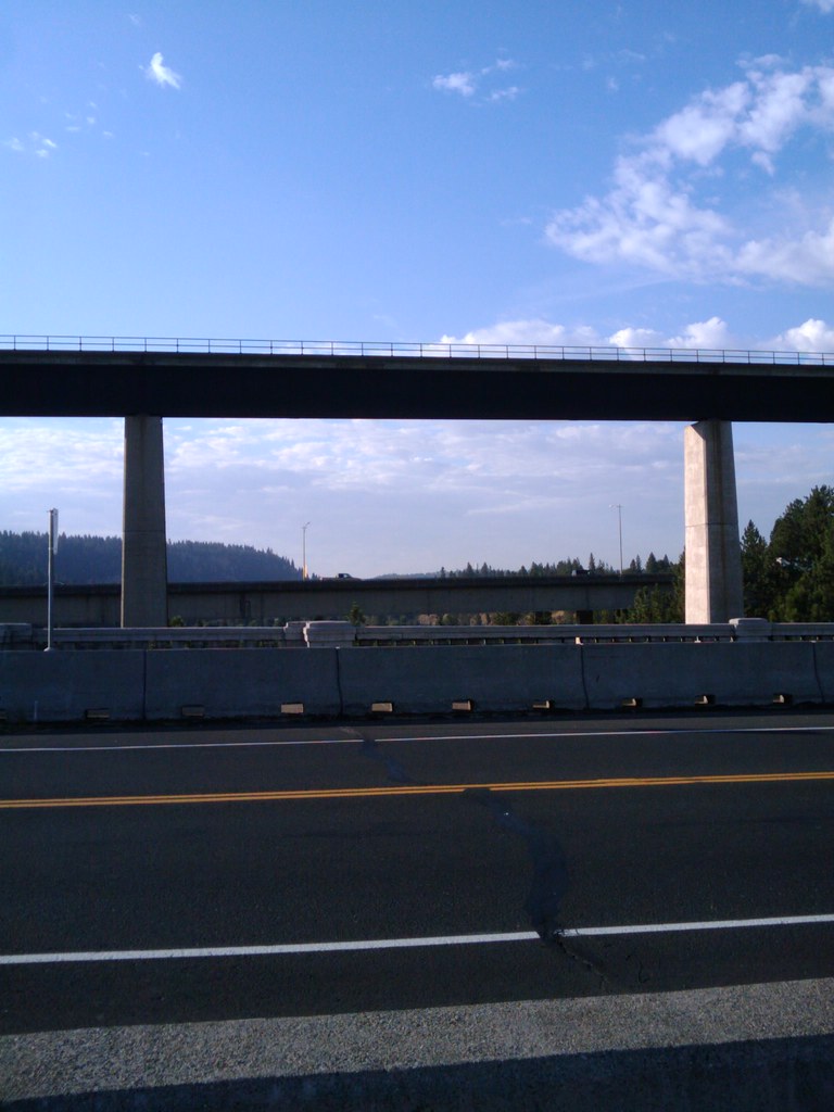
BNSF's Latah Creek railroad bridge in Spokane — commonly called High Bridge — towers up to 175 feet above the canyon floor. Built in 1972 by Burlington Northern, the 3,950-foot structure carries 50+ daily BNSF freights plus Amtrak's Empire Builder through a dramatic wye junction.
Photos
Sign in to upload photos![]() ikrichter
ikrichter
4
Trainspotting Experience
High Bridge Park, the 200-acre city park directly beneath the Latah Creek railroad bridge, provides the primary viewing access. The park sits at the confluence of Latah Creek and the Spokane River, giving railfans a unique perspective looking up at trains crossing 175 feet overhead. The bridge carries BNSF's Northern Transcon — one of the busiest freight corridors in the western United States — so the wait between trains is rarely more than 20-30 minutes during peak hours.
The bridge features a wye junction (Latah Junction) located on the bridge structure itself, where the route splits westward. The right fork heads toward Lions and the former Great Northern line to Seattle via Wenatchee, while the left fork crosses I-90 onto the former Spokane, Portland & Seattle Railway line heading south toward Pasco and Portland. Watching trains diverge at this mid-air junction is one of the spot's signature experiences.
Access is straightforward: the park is located at West Riverside Avenue and A Street, roughly 2 miles west of downtown Spokane. Street parking is available along Riverside Avenue and at the park's picnic area. The terrain within the park is steep in places, with trails dropping from the canyon rim down to creek level. Sturdy footwear is recommended, especially if descending to the creek for under-bridge perspectives.
Landscape, Setting & Local Atmosphere
The Latah Creek canyon was shaped by massive Ice Age floods that carved through the Columbia Plateau basalt. The terrain drops from approximately 1,900 feet above sea level at the canyon rim to roughly 1,720 feet where Latah Creek enters the Spokane River. Three bridges cross the canyon in close proximity: the BNSF railroad bridge (the tallest, completed 1972), the Interstate 90 bridge immediately to its south, and the historic 1913 Sunset Boulevard Bridge (a concrete arch bridge) to the north.
The park itself is mostly forested with ponderosa pine and native vegetation on the canyon slopes. The canyon creates a natural amphitheater effect that amplifies train sounds — locomotive horns, wheel flanges on the bridge's slight curvature, and air brake releases echo off the basalt walls. Spokane's continental climate means hot, dry summers with long daylight hours and cold winters that can dust the bridge and canyon with snow. The afternoon sun from the west provides dramatic backlighting for eastbound trains in summer.
Type & Frequency of Train Activity
The bridge is a critical junction on BNSF's Northern Transcon, the most northerly transcontinental freight route in the western United States. According to Trains Magazine, BNSF runs 50 or more freights daily through Spokane, plus approximately 8 or more Union Pacific trains operating via BNSF trackage rights between UP Junction (10 miles southwest) and Napa Street Junction (2 miles east of the Amtrak station).
Typical BNSF consists include unit grain trains, coal, double-stack intermodal, vehicle carriers, manifests, and the newer Bakken oil trains. Montana Rail Link trains also operate on BNSF trackage rights between Spokane's Yardley Yard and Missoula, Montana, adding visual variety with MRL blue power. UP trains bring yellow EMD and GE locomotives, sometimes with Canadian Pacific run-through power.
Amtrak's Empire Builder splits and combines at Spokane — trains 7/8 serve the Seattle section and trains 27/28 serve the Portland section. The combined eastbound train arrives around 1:15 AM, while westbound sections depart around 2:15-2:45 AM after splitting. These overnight schedules mean Amtrak sightings at Latah Bridge require commitment, but the distinctive Superliner consists are rewarding when caught in daylight during seasonal delays.
Best Angles for Photos & What Railfans Enjoy Most
The most accessible vantage point is from the trails within High Bridge Park at creek level, where wide-angle lenses (16-24mm) capture the full height and length of the bridge structure with trains crossing overhead. The perspective of double-stack containers seeming to float above the treetops at canyon-rim level is unique to this location.
From the canyon rim along West Sunset Boulevard, telephoto lenses (200mm+) compress trains against the Spokane skyline to the east. Afternoon light strikes the engineer's side of westbound trains from this angle. The Sunset Boulevard Bridge itself offers elevated views looking south toward the railroad bridge, though the angle is somewhat obstructed.
For variety, the I-90 corridor provides quick glimpses of the bridge from vehicles, but no safe stopping point exists on the interstate. Instead, use the park trails to reach different elevations along the canyon wall. Morning light favors the east-facing canyon walls, while afternoon and evening light from the west backlights trains dramatically.
Note that Spokane International Airport's approach path passes nearby, so drone use is restricted. The area falls within the airport's controlled airspace.
Historical or Cultural Relevance
The Latah Creek railroad bridge was built by Burlington Northern Railroad after the 1970 merger that united the Great Northern, Northern Pacific, Chicago Burlington & Quincy, and Spokane Portland & Seattle railways. Construction began in January 1971, with the bridge opening in December 1972 (formal dedication December 6, per Trains.com forum records and Spokesman-Review archives, though some sources cite 1973 for the opening date).
The $10 million bridge project (part of a larger $16.2 million line improvement that included seven miles of new track and 11 bridges) was central to BN's consolidation of Spokane rail operations. The bridge allowed Burlington Northern to remove its tracks from Havermale Island along the Spokane River, freeing the riverfront land that became Riverfront Park — the site of Expo '74, Spokane's World's Fair.
Architect Warren C. Heylman is credited with influencing the bridge's design. He reportedly wrote to Burlington Northern with unsolicited advice after seeing their initial heavily-trellised design, which would have obscured the historic arches of the 1913 Sunset Boulevard Bridge. The simpler design with long concrete piers and steel box girders that was ultimately built complements the nearby I-90 bridge.
The bridge also replaced the original "High Bridge" — an iron girder trestle built in 1881 that had carried rail traffic across the Spokane River and Latah Creek for nearly a century. That historic structure was demolished in the 1970s after traffic was rerouted to the new bridge.
What Makes This Spot Different
Latah Bridge is one of the few railfan locations where you can watch trains on a major transcontinental freight corridor from directly below, looking up at trains 175 feet overhead. The wye junction (Latah Junction) located on the bridge structure itself is operationally unusual — trains physically diverge or converge at the split while still crossing the canyon. This is where the Empire Builder route separates into its Seattle and Portland sections, and where BNSF directionally routes westbound freight up the former SP&S "Highside" and eastbounds down the former NP "Lowside" to manage grades.
The juxtaposition of three transportation bridges — railroad (1972), interstate (1963), and the historic concrete arch Sunset Boulevard Bridge (1913) — crossing the same narrow canyon creates a layered transportation tableau spanning over a century of engineering. High Bridge Park's free, unrestricted public access makes this one of the most convenient high-traffic railfan spots in the Pacific Northwest. The adjacent John A. Finch Arboretum (65 acres, free admission) and the park's disc golf course, dog park, and trails add options for non-railfan companions.
Frequently Asked Questions
QHow many trains per day cross Latah Bridge?
According to Trains Magazine, BNSF runs 50 or more freights daily through Spokane, plus 8 or more Union Pacific trains and 4 Amtrak Empire Builder sections (trains 7/8 to Seattle and 27/28 to Portland). Total traffic exceeds 60 movements per day.
QCan you see Amtrak's Empire Builder at Latah Bridge?
Yes, but the timing is challenging. The Empire Builder splits and combines at Spokane station in the early morning hours (roughly 1:15-2:45 AM). Occasional delays may push these into daylight hours, especially in winter.
QWhere is the best place to park for trainspotting at High Bridge?
Street parking is available along West Riverside Avenue near High Bridge Park. The park has a small parking area near the picnic shelter. The park is located at Riverside Ave. and A Street, approximately 2 miles west of downtown Spokane.
QIs there an admission fee for High Bridge Park?
No, High Bridge Park is a free public park open daily from 5 AM to 11 PM year-round. The adjacent John A. Finch Arboretum is also free.
QWhat railroad subdivision runs over Latah Bridge?
The bridge carries BNSF's Northern Transcon, which runs from Chicago to the Pacific Northwest. At Latah Junction on the bridge itself, the route splits into the Seattle line (via the former Great Northern route through Wenatchee) and the Portland line (via the former SP&S/NP route through Pasco).
Safety Tips
Stay on designated park trails — the canyon slopes are steep and the basalt rock can be loose. Never attempt to access the railroad bridge or tracks; the bridge is active BNSF property with no pedestrian access. The park area near Latah Creek can flood during spring runoff. Be aware of your surroundings, particularly in more secluded parts of the park. Spokane International Airport approach paths pass overhead, restricting drone use in the area.
Seasonal Information
Summer brings hot, dry conditions (highs often above 90°F/32°C) with excellent visibility and long shooting hours until 9 PM. Winter temperatures regularly drop below freezing with occasional snow that dramatically photographs against the bridge and orange BNSF locomotives. Spring (April-May) and fall (September-October) offer the most comfortable conditions with moderate temperatures and changing foliage. Wind can be significant in the canyon during shoulder seasons — secure tripods and use lens hoods.
Nearby Lodging
- West Wynn Motel
Budget motel at 2701 W Sunset Blvd, within walking distance of High Bridge Park. Pet-friendly. Extended stays available.
- Quality Inn & Suites Spokane Airport
Mid-range hotel at 4301 W Sunset Blvd, about 1 mile from Finch Arboretum. Free breakfast, airport shuttle, free parking.
- Hampton Inn Spokane
Mid-range hotel near the airport, about 4 miles west of downtown. Free hot breakfast, indoor pool, 24-hour fitness center.
- The Davenport Grand Hotel
Upscale downtown hotel connected to the Convention Center via skybridge. Walking distance to Riverfront Park and the BNSF elevated corridor through downtown.
Nearby Attractions
A 200-acre city park directly beneath the railroad bridge, with trails, disc golf course, dog park, picnic shelters, and playground. The park sits at the confluence of Latah Creek and the Spokane River.
0.5 miles / 0.8 km
65-acre botanical garden along Garden Springs Creek with labeled tree specimens, native pine forest, and rhododendron glen. Free admission, open daily.
25 miles / 40 km
Railroad museum near Reardan with nearly 30 rail cars and engines, railroad memorabilia, and a 2-foot gauge train ride. Open Fri-Sun, 10 AM to 5 PM seasonally. Adults $14.
2 miles / 3.2 km
Historic station at 221 W First Ave serving the Empire Builder. Watch the train split/combine operations in the early morning hours. BNSF elevated corridor runs through downtown.
2.2 miles / 3.5 km
Downtown park built on the former rail yard land vacated by Burlington Northern for Expo '74. Views of Spokane Falls and the historic Great Northern Clocktower.
External Links
informative
official
informative
informative
Looking for more spots? Browse the complete list of train spotting locations.
Quick Information
Country
USA
Region
Washington
City
Spokane
Spot Type
Bridge/Overpass
Best Times
BNSF and UP operate around the clock, but freight traffic peaks in early morning and late afternoon. The four Amtrak Empire Builder sections pass through Spokane in the early morning hours (approximately 1:15-2:15 AM), making them impractical for most railfans to observe here. Daylight freight watching is best.
Visit Duration
1-3 hours
Cost
Free (park access and parking)
Train Activity
Train Types
Frequency
50+ BNSF freights, 8+ UP freights, and 4 Amtrak Empire Builder sections daily (source: Trains Magazine)
Access & Amenities
Parking
Available (Free street parking along Riverside Avenue and at the park)
Shelter
Available
Restrooms
Available