

Spotting Location
Genesee Arch Bridge, Letchworth State Park
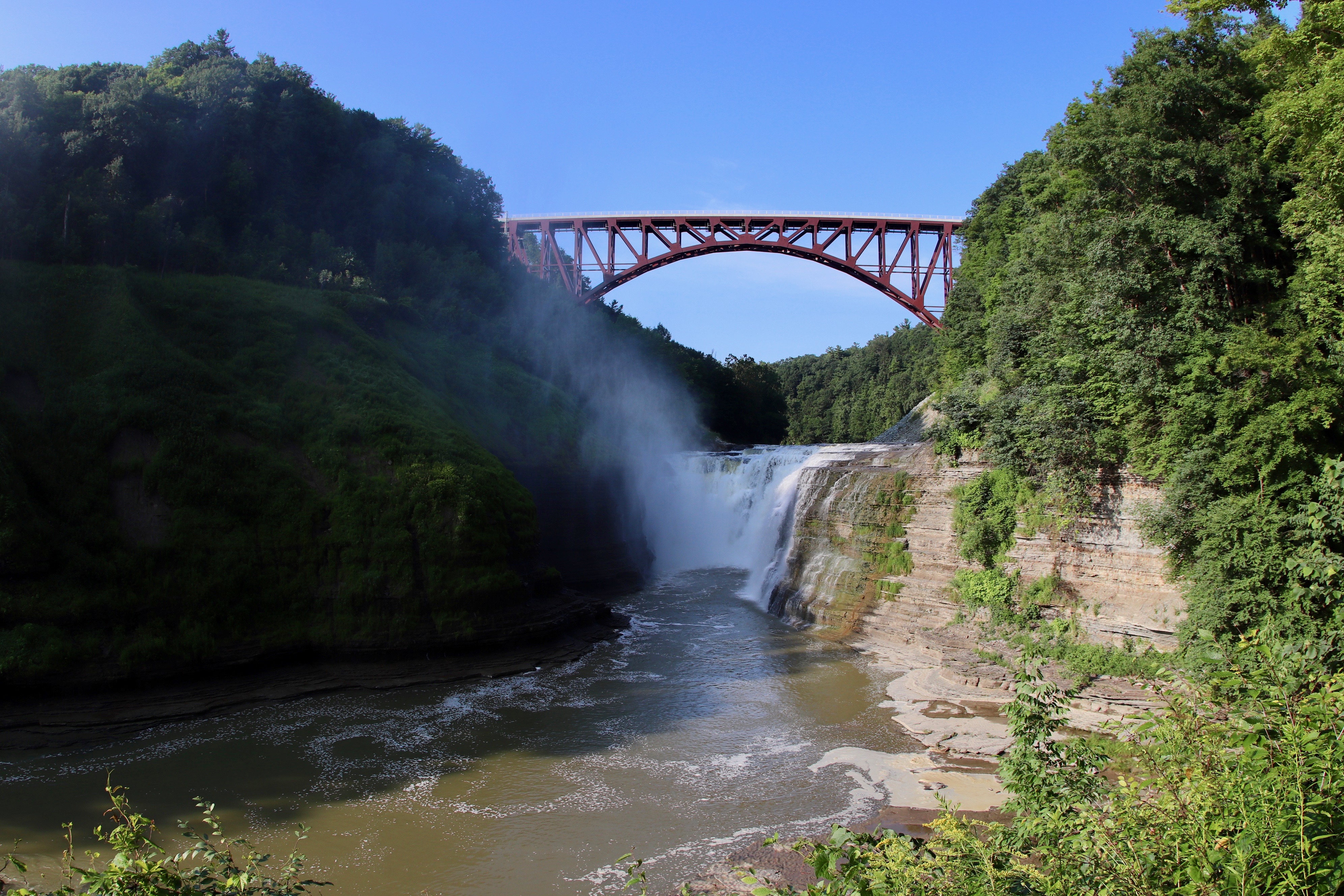
Gorge Trail viewpoint 180 m from Norfolk Southern's 963-foot Genesee Arch Bridge, a 2017 steel arch 235 feet above Letchworth State Park's Upper Falls.
Portageville, New York, United States
Verified on October 12, 2026
See everything in New York12 spots · 5 live cams · 2 experiences · 20 eventsPlan your visit
Coordinates: 42.579190, -78.048830
- Parking
- Fee
- Shelter
- Yes
- Restrooms
- Yes
Parking: Included in the Letchworth State Park vehicle use fee: $10 per vehicle, collected May 8 to October 18, 2026, 9 am to 5 pm daily (New York State Parks).
- Best times
- Summer mornings until about 11:00 EDT for front light on the bridge's north face; midday is backlit from the Gorge Trail. Park open 6 am to 11 pm.
- Duration
- 1-3 hours
- Cost
- State park vehicle use fee: $10 per vehicle ($35 buses), collected May 8 to October 18, 2026, 9 am to 5 pm daily (parks.ny.gov). No separate charge for the trail or viewpoint.
Where to stand, park and take a break
Before you go — access is not guaranteed
Photo positions show where photographers have stood, not places we have visited. Some may be on private or railway property. Stay on public land and never cross fences, tracks or “No Trespassing” signs: being on railroad property is illegal and dangerous. Parking and restrooms come from official and map sources.
Read our trainspotting safety, law & etiquette guide →Tap a symbol on the map for details.
Take this spot with you — every point in your GPS app, even without signal.
Weather & light
Sun times calculated for this spot’s coordinates.
Seasons
The park is open year-round, from 6 am to 11 pm daily, according to New York State Parks. The $10 vehicle use fee is listed as collected from May 8 to October 18, 2026, from 9 am to 5 pm daily; the park page lists no collection outside those dates and hours.
Winter changes the visit more than the fee does. The 2025 official park map shows the Portageville Entrance, the closest to the bridge, as closed in winter, and notes that sections of trail on the canyon edge are not usable in winter. Check the alerts on the park page before a cold-season trip.
The light changes sharply through the year at this viewpoint because it faces the bridge's north side. In late June the bridge face is sunlit from sunrise until about 11:00 EDT and again after about 20:00. Near the September equinox that front light ends at about 09:00 EDT, and in December the north face receives no direct sun at all, which leaves backlit or overcast compositions for the cold months.
No sourced seasonal pattern of train traffic was found, so choose the season for light, access and trail conditions rather than for an expected number of trains. Summer mornings combine the open Portageville Entrance, usable rim trails and the only front light of the year on the bridge.
Safety
Stay on marked trails and mapped viewpoints. The official park map warns that trail conditions change continually, asks visitors not to go beyond any "Do Not Enter" or "Trail Closed" sign, and says plainly: "Do not cross or stand on walls." The Gorge Trail near the Upper Falls follows the rim of the gorge, and the drop to the river at the bridge is 235 feet (72 m).
Never walk onto the bridge, its approaches or the railroad right-of-way. The track is Norfolk Southern property and pedestrian access to the bridge is prohibited. NYSDOT's environmental study for the replacement described trespassing on the old bridge by park visitors as a serious safety concern, given its height and the lack of a safe area for pedestrians if a train passed. Trains now cross at up to 30 mph (48 km/h), three times the 10 mph (16 km/h) permitted on the old bridge.
On the east side of the gorge, Trail 7 from the Middle Falls to the Genesee Arch Bridge is listed by New York State Parks as permanently closed. Do not use it to approach the bridge from that side.
In winter, the official map notes that sections of trail on the canyon edge are not usable, and it shows the Portageville Entrance, the closest to the bridge, as closed in winter. Plan cold-season visits accordingly and never improvise a route along the rim.
Park Road passes close to the parking area and the trailhead by the bridge; watch for vehicles when walking between the car and the Gorge Trail.
For emergencies, the official park map gives the Letchworth Park Police number, 585-658-4692, or 911.
Trains here
- Railroad
Norfolk Southern — Southern Tier Line
Train types
What runs here
The bridge carries Norfolk Southern's Southern Tier Line, which the railroad describes as its route between Buffalo and Binghamton, connecting New York shippers with markets in the Midwest and New England, trade with Canada and access to New York City. Norfolk Southern acquired this route and the bridge from Conrail in 1999, according to NYSDOT's environmental study for the replacement. The line is not electrified and the bridge is single track.
Traffic here is freight. Norfolk Southern states that trains crossing the new bridge operate at up to 30 mph (48 km/h) with fully loaded cars, up from the 10 mph (16 km/h) restriction on the old iron bridge, and that cars can now be loaded to the industry-standard 286,000 pounds (approximately 130 tonnes), where the old bridge forced loads 13,000 pounds (approximately 5.9 tonnes) below that standard. NYSDOT's study noted that trains more than a mile long were "not uncommon" on this crossing, especially long-distance trains, including international trains originating in Canada or the Midwest.
No current, sourced daily train count was found. The FRA grade-crossing records next to the bridge name the railroad and subdivision but carry no declared train count in Spotatrain's cache, Norfolk Southern publishes no schedule, and the only figure in the environmental study is a long-term projection of "an increase of three trains per day", not a count of today's traffic. Treat any visit as an open-ended wait.
The bridge has also carried occasional unusual moves. Railpace Newsmagazine published a photograph of a special Amtrak move crossing with an Avelia Liberty trainset on May 1, 2021, and News 8 WROC filmed Amtrak crossing the new bridge for the first time on January 9, 2020. These were one-off movements; Spotatrain found no regular passenger service on this segment.
On the line here
FRA / NTAD — crossing inventory Jul 21, 2026 · bridge inventory Oct 14, 2022 · rail yards (FRA / NTAD)
Photos & videos

 Andy Arthur
4

Ad Meskens
CC BY-SA 3.0

Ad Meskens
CC BY-SA 3.0

Ad Meskens
CC BY-SA 3.0

Gary Brownell
5
daveynin
4

tr.robinson
5

Dough4872
CC BY-SA 4.0

Andre Carrotflower
CC BY-SA 4.0
Swipe to see all 9 photos
Best angles for photos
The main view is from the Gorge Trail viewpoint, looking south-southwest (bearing approximately 195 to 205 degrees) at the north face of the bridge, about 180 m (590 ft) away. From here the two abutments span roughly 77 degrees of horizon: a 20 mm lens on a full-frame camera takes in the whole structure, while a standard 50 mm lens isolates the arch with the Upper Falls beneath it. A train on the deck reads as a thin line against the sky at the wide end, so a longer lens on the centre of the arch is the way to make the equipment itself visible.
Light is the main constraint, and it was computed for this position at latitude 42.58 degrees north. The bridge's north face looks toward a bearing of about 24 degrees and receives direct sun only when the sun is north of east-southeast or north of west-northwest. In late June that means from sunrise until about 11:00 EDT, and again after about 20:00. Around the September equinox it is lit only until about 09:00 EDT, and in December it receives no direct sun at all.
From about noon to 15:00 EDT in summer the sun moves across the southern sky behind the bridge (azimuth about 135 to 237 degrees), so midday frames are backlit: the arch and any train stand out in silhouette against a bright sky, with the falls in shade. Between about 16:00 and 19:00 EDT the sun is in the west (azimuth about 255 to 285 degrees) and rakes across the structure from the right while the north face stays shaded.
The viewpoints farther north on the Gorge Trail, at about 270 m (890 ft) and 340 m (1,120 ft), give the same orientation with more of the gorge in the frame. Railpace Newsmagazine notes that "several compositions are possible within the State Park". For every composition, stay on marked trails and at mapped viewpoints.
The full guide
Trainspotting Experience
The standing point is a viewpoint mapped on OpenStreetMap beside the Gorge Trail (Trail 1 on the official park map), about 180 m (590 ft) north of Norfolk Southern's Genesee Arch Bridge, looking south-southwest across the Genesee River gorge. From here the whole 963-foot (293.5 m) single-track span is in view, and the Upper Falls of the Genesee drop about 125 m (410 ft) in front of you, directly beneath the arch. The two abutments sit at bearings of roughly 159 and 236 degrees, so the bridge fills a wide arc of the southern horizon.
You reach it from the small parking area at the south end of the Gorge Trail, beside the bridge's west approach on Park Road, just inside the Portageville Entrance. The official 2025 park map marks both the parking area and the trailhead there. The walk along the trail to the viewpoint is approximately 240 m (800 ft) and crosses a short footbridge over a side ravine.
This is a waiting spot, not a busy main line. Norfolk Southern publishes no timetable for this freight route and no current daily train count was found for it, so plan to spend time at the rail and treat a train as a bonus rather than a certainty. The same trail continues north past further mapped viewpoints at about 270 m (890 ft) and 340 m (1,120 ft) from the track, which show the bridge behind the falls from farther back.
The better-known overlooks are much farther away. The Middle Falls viewpoints near the Glen Iris Inn sit about 830 to 890 m (roughly half a mile) from the bridge, and Inspiration Point is 1.6 km (1 mile) downstream: its OpenStreetMap viewpoint is described as facing the Upper and Middle Falls at a bearing of 210 degrees, which is also the direction of the bridge, so the span can only be a distant element of the gorge from there.
The bridge itself is off limits. NYSDOT's environmental review for the replacement records that park visitors used to trespass on the old viaduct to look at the falls, and states that pedestrian access is prohibited on the new bridge.
Landscape, Setting & Local Atmosphere
New York State Parks calls Letchworth the "Grand Canyon of the East": the Genesee River runs through the park over three major waterfalls between cliffs that reach 600 feet (183 m) in places. The railroad crosses at the southern, upstream end of that gorge, where Norfolk Southern describes the chasm under the bridge as 235 feet (72 m) deep.
The Genesee Arch Bridge is a steel arch whose main span measures 483 feet (147.2 m), with three 80-foot (24 m) girder approach spans at each end, according to its builder, American Bridge Company. The single track runs 235 feet (72 m) above the river. It replaced a viaduct whose supports stood in the gorge itself, and NYSDOT's environmental study expected the arch design to enhance views of the river by removing those supports. From the Gorge Trail the result is an open arch framing the Upper Falls.
The old iron viaduct stood about 75 feet (23 m) north of the new alignment, on the downstream side, directly over the falls, for more than 140 years. Its last pieces were demolished in March 2018, so today the falls, the arch and the wooded rim make up the whole scene.
From the viewpoint you look south-southwest, upstream toward the Portageville end of the park. The rim around the bridge is wooded, and parts of the Gorge Trail near the bridge are lined with stone walls built in the style of the park's historic walls; NYSDOT's study called for stone salvaged during construction to be reused there. Park Road runs a short distance behind the trail near the parking area, and the Mary Jemison Trail (Trail 2) leaves from the same corner of the park near the bridge's west abutment.
Historical or Cultural Relevance
Railroads have crossed the Genesee here since 1852. The Erie Railroad began a timber trestle on July 1, 1851, and opened it on August 14, 1852; Wikipedia records it as then the longest and tallest wooden bridge in the world. It was destroyed by fire in the early morning of May 6, 1875.
The Erie rebuilt in wrought iron the same year, and the new viaduct was carrying trains again by the end of July 1875. NYSDOT's environmental study describes it as a single-track truss structure spanning approximately 819 feet (250 m), 245 feet (75 m) above the gorge. It served several owners, from the Erie Lackawanna to Conrail, which took over the Southern Tier route in the 1970s; Norfolk Southern acquired the bridge and the route from Conrail in 1999.
By the 2000s the iron bridge was a bottleneck. The 2009 New York State Rail Plan identified its weight and speed restrictions as one of the top ten rail bottlenecks in the state, and Norfolk Southern had to hold trains to 10 mph (16 km/h) and car weights to 13,000 pounds below the industry standard. According to a 2011 Buffalo News report cited by Wikipedia, Norfolk Southern offered the old structure to the state as a viewing platform for the Upper Falls, and the state declined for lack of funding.
Norfolk Southern, NYSDOT and the state parks office broke ground on the replacement on October 28, 2015. Modjeski and Masters designed it for Norfolk Southern, and American Bridge Company built it on a parallel alignment 75 feet (23 m) south of the old bridge, so trains kept running during construction. The first train crossed on December 11, 2017, and the last pieces of the 1875 bridge were demolished on March 20, 2018.
The project cost $75 million: $59.5 million from Norfolk Southern and $15.5 million provided through New York State. At the dedication on May 24, 2018, Norfolk Southern announced the name Genesee Arch Bridge, the winner of a naming vote on social media, and said it had preserved portions of the old bridge for use in historical exhibits.
What Makes This Spot Different
The Upper Falls sit about 60 m (200 ft) downstream of the track, so the waterfall and a Class I freight bridge share a single frame from a public trail, 235 feet (72 m) above the river.
The structure itself is unusual. American Bridge Company calls it the "first true arch built for the railroad industry since the 1940's", and Norfolk Southern's vice president of engineering said at the dedication that "only a few arch bridges of this type have been built by the rail industry in the past century". NYSDOT's environmental review, while acknowledging that removing the 1875 viaduct was a loss for a bridge that appeared on park memorabilia, anticipated that the new bridge would in time become an iconic visual resource of Letchworth in its own right.
The name is recent. The crossing was known as the Portageville Bridge until May 24, 2018, when Norfolk Southern announced that "Genesee Arch Bridge" had won a naming vote on social media. New York State Parks now uses that name on its own pages, listing the Portageville Entrance as the access to the Upper Falls area and the Genesee Arch Bridge.
The site also shows how a freight main line and a heavily visited state park were fitted together. Under the alternative that was built, NYSDOT's study provided for moving the track 75 feet (23 m) south, relocating a section of Park Road and the small parking area near the bridge, and moving the trailheads of the Gorge Trail and the Mary Jemison Trail from railroad property onto park land. The result is a railfan viewpoint reached by an ordinary park trail rather than from railroad property.
Finally, the same crossing has now carried trains on three successive structures since 1852: timber, then iron, then steel.
Frequently Asked Questions
QIs there a fee to see the Genesee Arch Bridge?
The viewpoint is inside Letchworth State Park, which charges a vehicle use fee of $10 per vehicle ($35 for buses). New York State Parks lists the fee as collected from May 8 to October 18, 2026, 9 am to 5 pm daily. There is no separate charge for walking the Gorge Trail.
QWhere is the best place to watch trains cross the bridge?
A mapped viewpoint on the Gorge Trail (Trail 1), about 180 m (590 ft) north of the bridge, shows the whole span with the Upper Falls directly beneath it. It is approximately 240 m (800 ft) on foot from the parking area at the trail's south end, beside the bridge's west approach on Park Road.
QHow many trains cross the Genesee Arch Bridge each day?
No current, sourced daily count was found. The bridge carries Norfolk Southern freight on its Southern Tier Line between Buffalo and Binghamton, and Norfolk Southern publishes no timetable for it, so expect to wait.
QWhen was the Genesee Arch Bridge built?
Construction began on October 28, 2015, and the first train crossed on December 11, 2017. Norfolk Southern dedicated and named the bridge on May 24, 2018. It replaced an iron viaduct built by the Erie Railroad in 1875, which had itself replaced an 1852 timber trestle destroyed by fire.
QCan I walk on the bridge?
No. Pedestrian access to the bridge is prohibited and the track is Norfolk Southern property. Watch from the Gorge Trail viewpoints, stay on marked trails and do not cross or stand on walls.
QCan I bring my dog?
New York State Parks allows pets in Letchworth's day-use areas on a leash no longer than 6 feet (1.8 m), unless a sign prohibits them. Pets are not permitted on boardwalks or in buildings.
Help improve this page
Spotted something out of date or incorrect? Let our community know.
Around Portageville
2 places on Spotatrain within 50 km of Portageville — 2 events.
Spots Near Portageville
More Spots in New York
- Binghamton (Rail Yards)Spot · Binghamton, New York
- Selkirk Yard (Albany)Spot · Selkirk, New York
- Moodna ViaductSpot · Salisbury Mills, New York
- Poughkeepsie (Hudson Bridge)Spot · Poughkeepsie, New York
- Hudson Highlands (Cold Spring)Spot · Cold Spring, New York
- Croton-Harmon (Hudson Line)Spot · Croton-on-Hudson, New York
Nearby attractions
- Arcade & Attica Railroad19.3 miles / 31.1 km
Heritage railroad based at its depot on Main Street in Arcade, Wyoming County.
- Middle Falls0.4 miles / 0.7 km
The second of Letchworth's three major waterfalls, beside the Glen Iris Inn, reached along the same Gorge Trail.
- William Pryor Letchworth Museum0.5 miles / 0.8 km
Park museum near the Glen Iris Inn; New York State Parks lists the museum as included in the vehicle use fee.
- Inspiration Point1 miles / 1.5 km
The park's best-known overlook, facing the Upper and Middle Falls from about 1.6 km (1 mile) downstream of the bridge.
Hotels & places to stay near Portageville
Sources & official links
- Letchworth State Park - New York State Parksparks.ny.gov
- Letchworth State Park Map 2025 (PDF) - New York State Parksparks.ny.gov
- Norfolk Southern begins running trains over new Portageville Bridge (December 11, 2017)norfolksouthern.investorroom.com
- Norfolk Southern and New York State dedicate the Genesee Arch Bridge (May 24, 2018)www.prnewswire.com
- Portageville Bridge DEIS, Chapter 1: Executive Summary - NYSDOTwww.dot.ny.gov
- Portageville Bridge Replacement - American Bridge Companyamericanbridge.net
- Portage Viaduct - Wikipediaen.wikipedia.org
- Railfanning the NS Southern Tier Line Part 1: Buffalo to Hornell - Railpace Newsmagazinerailpace.com