



Spotting Location
Tunkhannock Viaduct (Nicholson Bridge)
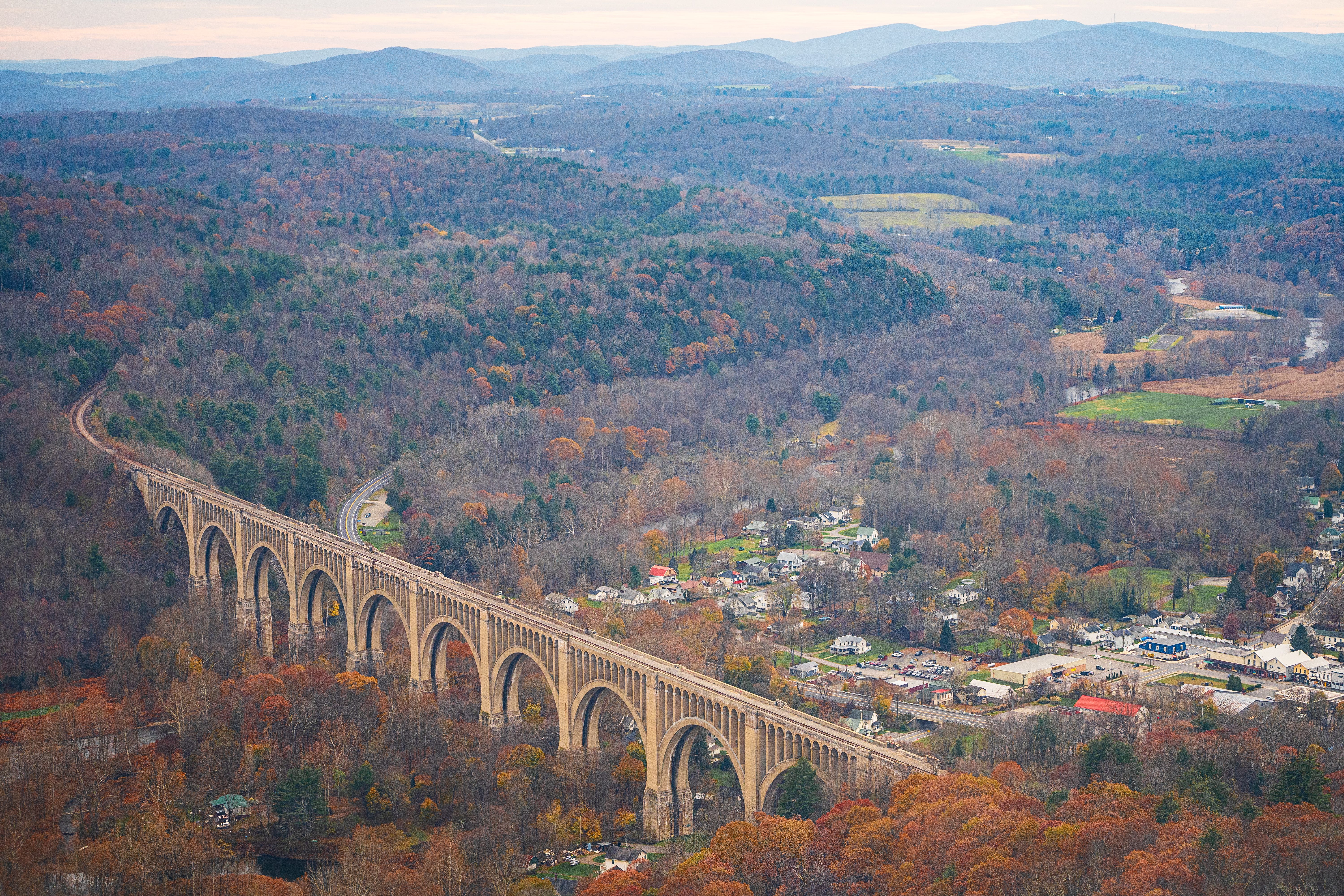
A roadside park on US 11 half a mile south of Nicholson looks north-northeast at the 1915 Tunkhannock Viaduct, 2,375 ft (724 m) of concrete arches still carrying Norfolk Southern freight.
Nicholson, Pennsylvania, United States
Verified on September 21, 2026
Plan your visit
Coordinates: 41.620649, -75.779042
- Parking
- Yes
- Shelter
- None
- Restrooms
- None
- Best times
- Because the structure runs almost exactly north-south, the park on the west side is an afternoon and evening position: the west elevation takes the sun from roughly midday until it sets behind the 1,200 to 1,300 ft (366 to 396 m) hills. Morning belongs to the east elevation, reached from Farnham Road just east of Nicholson. Any hour works for the looking-up-the-piers shot from State Street, which passes under the viaduct in permanent shade. Nothing here is gated or locked, so the park itself is reachable at any hour; there is no published schedule to wait for, so plan on a long stay rather than a timed one.
- Duration
- 45 to 90 minutes for the roadside park, the interpretive panels and the pier view from State Street. With no published schedule, allow an hour or more if you want a train. A half day adds Farnham Road and the Martins Creek Viaduct overlook 13 km (8 mi) up the line.
- Cost
- Free. The vantage point is a public roadside park and pull-out on US 11 carrying the Pennsylvania state historical marker; no source consulted mentions any admission or parking charge.
Weather & light
Sun times calculated for this spot’s coordinates.
Seasons
The park is an unlocked roadside pull-out with no season, but what you can see from it changes. In leaf-off months, roughly late autumn through early spring, the bare hillsides expose the Catskill Formation sandstone and red shale cuts that the 2004 field-trip guidebook describes along both US 11 and the active railway north and south of the viaduct, and the full ten-arch elevation stands clear of foliage from the hilltop cemetery west of town. In full leaf the wide shots from the cemetery and from Farnham Road close up, and the park's own sightline becomes the reliable one. September is the month with an event attached: Nicholson has marked the building of the bridge with Nicholson Bridge Day since 1990, held on the second Sunday of September according to Wikipedia and the railfanguides.us entry, with a street fair, parade, craft and food vendors; the centennial was celebrated in September 2015. Expect crowds and closed streets in the borough that day, and expect the same at any announced special movement, as happened for Union Pacific Big Boy 4014 on 13 June 2026. Summer brings more maintenance traffic, which is the one predictable change in the train mix: the NEPA Trains guide notes that maintenance-of-way crews are very active in summer and that a hi-rail inspects the track about once a weekend year-round. Winter shortens the usable afternoon light on the west elevation considerably, since the sun sets behind hills 500 to 600 ft (150 to 180 m) above the valley floor rather than on a flat horizon.
Safety
The hazard here is road traffic, not the railway. US 11 at this point is a two-lane primary highway with a 35 to 45 mph posted limit, it is a PennDOT-designated truck route, and OpenStreetMap records no sidewalk on any of its segments through Nicholson. The park is on the southbound side, so arriving from the north you turn right into it directly and never cross the carriageway; arriving from the south, do not park on the opposite shoulder and walk across, because the state historical marker sits on the far side of the highway and the temptation to cross mid-block is real. Keep children and tripods off the shoulder. The second hazard is the valley itself: the ground falls away toward Tunkhannock Creek, the creek runs at about 700 ft (213 m) against hills of 1,200 to 1,300 ft (366 to 396 m), and the field-trip guidebook that surveyed this spot describes at least 50 ft (15 m) and locally nearly 100 ft (30 m) of loose glacial outwash and ice-contact drift filling the valley floor, which is not stable footing. Stay on the made ground of the park. The railway itself needs no negotiation from this position and should get none: there is a single main track 240 ft (73.2 m) overhead under centralised traffic control at 40 mph, the deck and the track are Norfolk Southern property, and no source consulted describes any legal public access onto the structure or along it. The piers are readable from State Street below, which is a public road, but do not read that as permission to climb an abutment or walk the fill. Finally, the timing: with no published schedule and the guide's own timing column deleted, do not improvise a closer position because nothing has come; the park is the position.
Trains here
Through trains per day
6reported to the FRA — Delaware & Hudson South Line only
More than one line meets here. This count covers the Delaware & Hudson South Line alone — trains on the Sunbury Line are not included.
Daytime
1
6 AM – 6 PM
Nighttime
5
6 PM – 6 AM
≈ 1 every 2.5 h
Reported by the railroad for FRA grade crossing 264294S, 670 m from this spot (FRA inventory, July 2026). An estimate, not a schedule.
- Railroad
Norfolk Southern — Delaware & Hudson South Line (D&H South) / Sunbury Line
≈ MP 653 on the Delaware & Hudson South Line (D&H South) — derived from FRA grade crossing 264294S, 670 m away
- Track at the crossing
- 1 main track · 40 mph timetable speed
Train types
What runs here
Everything that crosses is Norfolk Southern, which has owned this track since it completed its purchase of the Delaware & Hudson South Line and began operating at 12:01 a.m. on 19 September 2015. The NEPA Trains railfan guide to the line lists seven current symbols, of which four run through Nicholson because their endpoints bracket it: 12Z, Roanoke, Virginia to Binghamton, New York, daily; 11Z, Binghamton to Roanoke, daily; K82, Scranton to Binghamton, Saturdays and Sundays; and H97, Binghamton to Taylor, Pennsylvania, Mondays to Fridays. The remaining three in that guide (K81 Scranton-Wilkes Barre, DL3 the Steamtown-Taylor runner, PISB the Reading Blue Mountain & Northern's Pittston-Taylor runner) work south of Taylor Yard and do not reach the viaduct. The same guide reports that autoracks turn up on southbound trains but never on northbounds, that maintenance-of-way movements are commoner in summer, and that a hi-rail inspects the track roughly once each weekend. Commodities it names are intermodal, sand and rock in hoppers, fuel in tank cars, lumber on centrebeams and boxcars; the Broadcastify feed description adds grain, coal and automotive. Since the Norfolk Southern era began the schedule has loosened: the NEPA Trains guide has removed its "Usual Time" column outright, noting that most trains lost their regularity after precision scheduled railroading came in, so there is no window to plan around. Historical figures belong here rather than in any frequency claim: before the cut-off opened in 1915 the old line needed helper engines added at LaPlume, Nicholson and Hallstead for every heavy westbound anthracite train that got past Clarks Summit, and the cut-off did away with all three. Named Lackawanna and Erie Lackawanna passenger trains, the Phoebe Snow, the Owl and the New York Mail, used the viaduct but did not stop in Nicholson. One dated modern working: Union Pacific Big Boy 4014 crossed the viaduct on 13 June 2026 on its Coast-to-Coast Tour.
On the line here
FRA / NTAD — crossing inventory Jul 21, 2026 · bridge inventory Oct 14, 2022 · rail yards (FRA / NTAD)
Photos & videos

 davidwilson1949
4

davidwilson1949
4

andyarthur
4

andyarthur
4

andyarthur
4

Mr. Matté (if there is an issue with this image, contact me using this image's Commons talk page , my Commons user talk page , or my English Wikipedia user talk page ; I'll know about it a lot faster)
CC BY-SA 4.0

Mr. Matté (if there is an issue with this image, contact me using this image's Commons talk page , my Commons user talk page , or my English Wikipedia user talk page ; I'll know about it a lot faster)
CC BY-SA 4.0

Bruce Fingerhood from Springfield, Oregon, US
CC BY 2.0
Pstark1
CC BY-SA 4.0
WallyFromColumbia at English Wikipedia
Public domain
Swipe to see all 10 photos
Best angles for photos
The structure's axis runs on a bearing of about 5 to 185 degrees, computed from the nineteen mapped nodes of the OpenStreetMap way that carries it, which means it is effectively north-south and presents a clean east elevation and a clean west elevation rather than an oblique. The park on US 11 is on the west side, so it delivers the west elevation in afternoon and evening light. Fitting all 2,375 ft (724 m) into one frame is the real constraint: at the 450 to 470 m (1,480 to 1,540 ft) the park sits from the centre of the structure, it subtends roughly 75 to 78 degrees, which needs something near 22 to 23 mm on a 36 mm-wide full-frame sensor; backing off to about 640 m (2,100 ft) brings that to roughly 32 mm. Anything longer than about 50 mm gives arches, not the bridge. The Historic American Engineering Record survey of this structure, catalogued as PA,66-NICH,1, is a useful shot list because it is entirely photographic: its three general-elevation views were taken with a barn in the foreground, looking northwest, and with the cemetery in the foreground. That last one confirms the hilltop cemetery west of town as the recorded wide vantage, and PA Bucket List reaches the same conclusion independently, calling the cemetery a point where the scale becomes apparent. For morning light on the east elevation, PA Bucket List names Farnham Road just east of Nicholson. The close work is on State Street, which is Pennsylvania Route 92 and passes directly beneath the viaduct 0.2 mi east of US 11: HAER photographed the pier detail, the concrete surface treatment and the "LACKAWANNA RAILROAD" lettering cast into the structure from down there, and the ASCE and National Railway Historical Society plaques are mounted on a pier at that spot. For scale in a single frame, remember the ratio: a 34 ft (10.36 m) deck above a 240 ft (73.2 m) drop means a locomotive occupies a very small part of the picture, so a train is a detail on this subject and not the subject.
The full guide
Trainspotting Experience
This is a wait-and-watch position, not a lineside one, and the distance is the whole point. From the parking area behind the guide rails on US 11 the middle of the viaduct is about 450 to 470 m (1,480 to 1,540 ft) away on a bearing of roughly 28 degrees, so a train crossing reads as a thin line moving along the top of a structure that stands 240 ft (73.2 m) above the creek on a deck only 34 ft (10.36 m) wide. You hear a train well before you see it and you get a long look: the crossing takes the full 2,375 ft (724 m) at the 40 mph (64 km/h) limit that both OpenStreetMap and the federal grade-crossing records give for this track. There is one main track, so there is never a meet on the structure and never a second train to divide your attention. What you are watching for, in practice, is one of four Norfolk Southern symbols that the NEPA Trains guide lists as running through Nicholson, and since that guide has deleted its timing column because trains lost their regularity under precision scheduled railroading, the honest expectation is hours between crossings rather than minutes. The scanner helps: the whole line from CP Kase to Binghamton is carried on a public Broadcastify feed maintained by Ronald Zukosky, covering seven counties, and the line is signalled with centralised traffic control, so radio traffic gives warning that nothing visual does. Between trains the park itself is the interest. HistoricBridges.org describes an interpretive area at the bridge carrying an extensive historical narrative with construction photographs, and the Pennsylvania state historical marker stands here, dedicated 15 September 1995 at "Nicholson Bridge, US 11, 1/2 mile S of Nicholson". You are also standing on history: US 11 at this point follows the right-of-way of the old Lackawanna main line that this cut-off was built to replace, so the road under your feet is the railway the viaduct made redundant.
Landscape, Setting & Local Atmosphere
Nicholson sits where Martins Creek comes down from the north to join Tunkhannock Creek, and the viaduct crosses that junction valley at its widest. The 2004 Friends of the Pleistocene field-trip guidebook, which brought a full field party to this exact parking area as its Stop 11, measured the setting: the valley is about 1,300 ft (400 m) wide where the bridge crosses it while the creek itself is only about 100 ft (30 m) wide, the hills to north and south rise to between 1,200 and 1,300 ft (366 to 396 m), and the stream runs at about 700 ft (213 m). The US Geological Survey puts the borough at about 735 ft (224 m). To hold the eased grades of the new line the Lackawanna set the rail elevation at exactly 947.0 ft (288.6 m), and the 240 ft (73.2 m) of air beneath it is simply the difference. The rock is Late Devonian Catskill Formation, interbedded grey sandstones with red shales, siltstones and mudstones, and the same guidebook notes extensive exposures of it along US 11 and along the active railway both north and south of the viaduct. Over that bedrock sits Late Wisconsinan glacial fill, silty till on the hills and outwash and ice-contact drift in the valley floors, at least 50 ft (15 m) deep across the whole valley and locally close to 100 ft (30 m), which is why the piers had to be driven so far down. The effect from the park is a structure entirely out of scale with what surrounds it: ten 180 ft (54.9 m) arches stepping across a valley of farm fields and clapboard houses, in a borough whose population was about 900 when construction began. Theodore Dreiser, quoted on the state marker here, called it "one of the true wonders of the world" and elsewhere the "great white bridge"; locally, as the field-trip guide puts it, "the viaduct will always be the Nicholson Bridge".
Historical or Cultural Relevance
The viaduct is the centrepiece of the Delaware, Lackawanna & Western's Nicholson Cut-Off, a 39.6 mile (63.7 km) relocation between Clarks Summit and Hallstead begun in May 1912 and opened to its first revenue train on 6 November 1915 at a total cost of about $14 million. The National Railway Historical Society plaque mounted on a pier here, erected 6 October 1990, records the engineering payoff in the railway's own accounting: main line shortened 3.6 miles, gradient reduced from 1.23 to 0.68 per cent, curvature reduced from 3,970 to 1,570 degrees, and 22 grade crossings eliminated. Wikipedia converts that shortening into time saved: 21 minutes for a passenger train or a full hour for a freight. The curve work mattered more than the mileage, since about half the old line was curved and the new alignment held nearly everything to 2 degrees or less, good for 70 mph and better, where some old curves exceeded 6 degrees and held trains to 35 mph. Abraham Burton Cohen designed the structure, in the Beaux Arts manner according to the 2004 field-trip guidebook; George J. Ray was chief engineer, the same man who had just finished the Lackawanna Cut-Off in New Jersey, and Flickwir & Bush of New York were the contractors under W. H. Truesdale's presidency. The plaque's own materials tally reads: 163,000 cubic yards of concrete, 2,500,000 lb of reinforcing steel, 185,000 barrels of cement, 48,000 cubic yards of foundation excavation. The piers went down to bedrock as much as 138 ft (42 m) below ground, almost half the bridge's bulk is underground, and quicksand at piers 5 and 6 forced pneumatic chambers. Five hundred men worked around the clock, and HistoricBridges.org records that the 900-person borough took in about 2,600 more people during construction. It was listed on the National Register of Historic Places on 11 April 1977 under reference 77001203, on a nomination submitted in August 1976 that argued the structure was "the literal keystone in the early-twentieth-century modernization of a major railroad". It is also an ASCE National Historic Civil Engineering Landmark, a date the sources disagree on: Wikipedia says 1975, the plaque on the pier reads "ASCE 1976". Concrete railings added in 1940 have weathered worse than the 1915 work beneath them.
What Makes This Spot Different
Three things set this apart from an ordinary bridge vantage. First, the scale claim has held for over a century: the Tunkhannock Viaduct was the largest concrete structure in the world when it opened in 1915, and HistoricBridges.org notes it still appeared to hold the record as late as 1990. Its total weight is put at approximately 670,000,000 lb (300,000,000 kg). Second, the arch count is genuinely disputed and worth knowing before you count them from the park. Wikipedia and american-rails.com give ten spans of 180 ft (54.9 m) on eleven piers; the Nicholson Heritage Association and HistoricBridges.org both say twelve arches, the ten big ones plus a 100 ft arch at each end completely buried in the approach fill. Both are right about different things, and only ten are visible. Third, this is one leg of a matched pair. The Martins Creek Viaduct near Kingsley, about 13 km (8 mi) up the same line in Susquehanna County, was built for the same cut-off and finished first, briefly making it the world's largest reinforced-concrete bridge before Nicholson took the title; at 1,600 ft (488 m) long and 150 ft (45.7 m) high it remains, per the Endless Mountains Visitors Bureau, the second largest of its kind, and it too has a public overlook with parking on Zicks Hill Road. The same cut-off also carries the 3,629 ft (1,106 m) Nicholson Tunnel, the only tunnel on the line and the only brick-lined tunnel the Lackawanna ever built. Two smaller things: US 11, the road you park beside, runs on the right-of-way of the old main line the cut-off replaced, so the viewing spot is itself former railway; and on 13 June 2026 Union Pacific Big Boy 4014 crossed the viaduct on its Coast-to-Coast Tour, an event the Nicholson Heritage Association still sells souvenirs of.
Frequently Asked Questions
QWhich railway owns and runs this track today?
Norfolk Southern Railway. It completed its purchase of the Delaware & Hudson South Line from Canadian Pacific on 18 September 2015 and began operating the corridor at 12:01 a.m. on 19 September 2015. OpenStreetMap tags the viaduct itself with both owner and operator as Norfolk Southern Railway, and the Pennsylvania Historical and Museum Commission's ExplorePAhistory entry states the viaduct currently operates under Norfolk Southern ownership. Historic names you will meet in the literature, DL&W, Erie Lackawanna, Conrail, D&H, Guilford and Canadian Pacific, are all former owners, not the present one.
QIs it one track or two on the bridge?
One today, two as built. The viaduct was built for a double-track main line, which is why Wikipedia's and american-rails.com's data tables both show two tracks. The NEPA Trains railfan guide states the line has had "its second track removed", the federal bridge inventory records "One" track over Tunkhannock Creek, the two federal grade-crossing records nearby each show one main track, and OpenStreetMap maps a single rail way across the structure tagged "Main Track". Do not expect a meet on the bridge.
QHow many trains cross, and can I plan around them?
There is no operator-published figure and no public schedule. The Broadcastify scanner-feed page covering the whole line states "The line see's on average 8-14 trains per day", which is an average for the entire route from CP Kase to Binghamton rather than a count at Nicholson. The NEPA Trains guide lists four Norfolk Southern symbols whose endpoints bracket Nicholson (12Z and 11Z daily, K82 weekends, H97 weekdays) but has removed its "Usual Time" column because trains lost their regularity under precision scheduled railroading. Plan for an open-ended wait.
QWhere exactly do I stand, and is it legal?
At the Tunkhannock Viaduct Park, a public pull-out on the southbound side of US 11 about half a mile south of Nicholson, parking lot at 41.620649, -75.779042. PA Bucket List calls it the "official" place to view the bridge; the Endless Mountains Visitors Bureau lists a Tunkhannock Viaduct Overlook on Route 11; HistoricBridges.org describes an interpretive area at the bridge; and the Pennsylvania state historical marker stands there, dedicated 15 September 1995. A 2004 geology field-trip guidebook brought an entire field party to this same lot as its Stop 11, instructing drivers to "turn RIGHT into parking area behind guide rails. Disembark." It is free and requires no trespass. The bridge deck and track are Norfolk Southern property and are not accessible.
QWhat lens do I need to get the whole bridge?
Something wide. The structure is 2,375 ft (724 m) long and runs almost due north-south, so from the park at about 450 to 470 m (1,480 to 1,540 ft) from its centre it fills roughly 75 to 78 degrees, needing about 22 to 23 mm on a 36 mm-wide full-frame sensor. From about 640 m (2,100 ft) back that eases to roughly 32 mm. For the west elevation shoot afternoon and evening; for the east elevation go to Farnham Road east of town in the morning; for pier detail and the cast "LACKAWANNA RAILROAD" lettering, go under the structure on State Street (PA 92).
QIs there anything else rail-related nearby?
Yes. The Martins Creek Viaduct near Kingsley, about 13 km (8 mi) up this same Nicholson Cut-Off, is its sister structure: 1,600 ft (488 m) long, 150 ft (45.7 m) high, finished first, and according to the Endless Mountains Visitors Bureau still the second largest concrete bridge of its kind, with its own overlook and parking on Zicks Hill Road. In Nicholson itself the Nicholson Heritage Association runs the Nicholson Tourism Center in the historic DL&W railroad station. Steamtown National Historic Site in Scranton, in the DL&W's own former Scranton Yards, is about 25 km (16 mi) south.
Help improve this page
Spotted something out of date or incorrect? Let our community know.
Around Nicholson
1 place on Spotatrain within 25 km of Nicholson — 1 live cam.
Spots Near Nicholson
More Spots in Pennsylvania
- Macungie Railfan PavilionSpot · Macungie, Pennsylvania
- Rockville BridgeSpot · Marysville, Pennsylvania
- Enola Yard (Harrisburg)Spot · East Pennsboro Township, Pennsylvania
- Lewistown (NS Main)Spot · Lewistown, Pennsylvania
- Kinzua BridgeSpot · Hamlin Township, Pennsylvania
- Horseshoe CurveSpot · Altoona, Pennsylvania
Related Experiences
Related Journeys & Mega-Projects
Nearby attractions
- Martins Creek Viaduct Scenic Overlook8.2 miles / 13.1 km
The Tunkhannock Viaduct's sister structure on the same Nicholson Cut-Off, built 1912 to 1914 for the DL&W and finished first, which briefly made it the world's largest reinforced-concrete bridge. Eleven arches, 1,600 ft (488 m) long and 150 ft (45.7 m) high, still carrying Norfolk Southern freight. The Endless Mountains Visitors Bureau calls it the second largest of its kind today and names the overlook on Zicks Hill Road near Kingsley, with parking and informational signage.
- Nicholson Tourism Center at the Historic DL&W Railroad Station0.4 miles / 0.6 km
The Delaware, Lackawanna & Western station in Nicholson, run by the Nicholson Heritage Association, which was established in 1989 ahead of the viaduct's 75th anniversary and is restoring the building. It is the local source for the viaduct's story and the organiser behind Nicholson Bridge Day, held on the second Sunday of September since 1990.
- ASCE and NRHS plaques under the viaduct, State Street0.4 miles / 0.6 km
Two plaques mounted on a viaduct pier on State Street (Pennsylvania Route 92) 0.2 mi east of US 11, readable from the public road. The National Railway Historical Society plaque, erected 6 October 1990, carries the railway's own engineering tally for the cut-off: main line shortened 3.6 miles, gradient reduced from 1.23 to 0.68 per cent, curvature reduced from 3,970 to 1,570 degrees, 22 grade crossings eliminated. The second marks the structure as an ASCE National Historic Civil Engineering Landmark.
- Steamtown National Historic Site15.6 miles / 25.1 km
A National Park Service site at 150 South Washington Avenue, Scranton, laid out in the Delaware, Lackawanna & Western's own former Scranton Yards, with a roundhouse complex, a working turntable, an active railyard and a locomotive collection. Open daily 9:30 a.m. to 5 p.m. in peak season, with train rides Friday through Sunday. The same railway that built the Tunkhannock Viaduct built these yards.
- Nicholson hilltop cemetery viewpoint0.5 miles / 0.8 km
The cemetery on the hill west of Nicholson, identified independently by PA Bucket List as a vantage where the bridge's scale becomes apparent and by the Historic American Engineering Record, whose survey PA,66-NICH,1 includes a general-elevation view taken with the cemetery in the foreground. It gives the full ten-arch west elevation from higher ground than the US 11 park, best in leaf-off months.
Hotels & places to stay near Nicholson
Sources & official links
- Tunkhannock Viaduct historical marker - ExplorePAhistory (Pennsylvania Historical and Museum Commission)explorepahistory.com
- Nicholson Heritage Association - Tunkhannock Creek Viaductwww.nicholsonheritage.org
- Tunkhannock Viaduct - Endless Mountains Visitors Bureauendlessmountains.org
- Norfolk Southern completes acquisition of Delaware & Hudson South Line (18 September 2015)www.norfolksouthern.com
- Stop 11: Tunkhannock Viaduct - 2004 Friends of the Pleistocene field conference guidebook (SUNY New Paltz)www2.newpaltz.edu
- Tunkhannock Viaduct (Nicholson Bridge) - HistoricBridges.orghistoricbridges.org
- NS Sunbury Line Guide - NEPA Trains (railfan guide)nepatrains.org
- Nicholson PA / Tunkhannock Viaduct Railfan Guide - railfanguides.uswww.railfanguides.us