Spotting Location
Saint Croix Junction
Saint Croix Junction marks where BNSF's St. Croix Subdivision meets joint BNSF-CPKC trackage near Hastings, Minnesota, handling 55-60 trains daily on ex-Chicago Burlington & Quincy tracks along the Mississippi River corridor.
Updated
Photos
No photos yet — be the first to share one!
Trainspotting Experience
Saint Croix Junction sits at milepost 392.1 on BNSF's St. Croix Subdivision, the point where the double-tracked main line transitions to joint BNSF-CPKC trackage heading northwest into St. Paul. The junction is controlled by the St. Croix Dispatcher based in Fort Worth, Texas, using Centralized Traffic Control installed in the 2010s. With 55-60 trains rolling through every 24 hours, waits between trains rarely exceed 30 minutes during peak periods.
The approach from the southeast brings trains off the Prescott lift bridge and along the Mississippi River bluffs. You can hear air horns echoing off the river valley well before locomotives come into view. The traffic is overwhelmingly freight — long intermodal stacks, unit grain and coal trains from the Dakotas, ethanol blocks, and mixed manifests carrying auto racks, tank cars, and lumber. CPKC (formerly Canadian Pacific/Soo Line) also runs overhead movements through here under trackage rights, adding variety to the motive power mix.
The junction area features two main tracks with CTC signaling. Watching dispatching decisions unfold in real time — which track gets which priority train — adds an operational dimension beyond just watching trains pass.
Landscape, Setting & Local Atmosphere
The junction sits in the Mississippi River corridor east of Hastings, where the terrain rises from the river floodplain into wooded bluffs. The St. Croix River empties into the Mississippi roughly 2 miles southeast at Point Douglas, placing this spot at the confluence of two major Upper Midwest waterways. The landscape is a mix of river bottomland, mature hardwood forest, and residential areas along the bluffs.
In autumn, the surrounding maple, oak, and sumac canopy turns vivid red and gold, creating a natural backdrop that contrasts sharply with orange BNSF locomotives. Spring mornings often produce river fog that drifts across the tracks, lending an atmospheric quality to photographs. Summer offers long daylight hours and lush green vegetation, while winter strips the leaves away and opens up sightlines through the bare trees. The proximity to the Mississippi keeps humidity noticeable in summer but also softens harsh midday light.
Type & Frequency of Train Activity
BNSF's St. Croix Subdivision is one of the busiest freight corridors in the Upper Midwest, forming part of the Northern Transcon — BNSF's primary Chicago-to-Seattle route. The line handles 55-60 trains per day across its approximately 150 miles from La Crosse, Wisconsin, to St. Paul, Minnesota.
Traffic is dominated by high-priority intermodal trains (Z-trains and S-trains) connecting Chicago with Pacific Northwest terminals, unit grain trains originating in the Dakotas and western Minnesota, unit coal trains from the Powder River Basin in Wyoming, ethanol unit trains, and general manifest freight carrying everything from auto racks to forest products. CPKC operates overhead trains through the junction under a trackage-rights agreement that extends from St. Croix Junction to Hoffman Avenue in St. Paul.
The line is double-tracked for most of its length, with exceptions between Burns and Prescott, Mears and Trevino, and Winona Junction to East Winona. Double track construction dates to 1926-1929. Automatic Block Signals were installed between 1917 and 1928, later replaced by modern CTC in the 2010s.
Best Angles for Photos & What Railfans Enjoy Most
The junction's position along the Mississippi River corridor offers several vantage points. From elevated ground on the bluffs west of the tracks, telephoto lenses (200-400mm) compress the double-track main line and capture trains against the river valley backdrop. Morning light from the east illuminates train faces on the westbound track, while afternoon sun favors the eastbound.
The nearby Prescott lift bridge (milepost 407.6) is a separate but worthwhile photo location about 15 miles southeast, where the BNSF crosses the St. Croix River on a 615-foot steel truss with a vertical lift span built in 1984. A live PTZ webcam streams from Scabs Place in Prescott, allowing you to scout conditions remotely before driving out.
For broadside shots, look for stretches where public roads parallel the tracks at a safe distance. The bluff-and-river scenery provides natural framing that eliminates the need for tight crops. In winter, bare deciduous trees open up angles that are hidden behind foliage the rest of the year.
Historical or Cultural Relevance
The St. Croix Subdivision was constructed in 1886 by the Chicago, Burlington & Northern Railroad, a subsidiary of the Chicago, Burlington & Quincy Railroad (CB&Q). The line provided CB&Q with its own route into the Twin Cities, following the Mississippi River from La Crosse, Wisconsin. Double tracking was completed between 1926 and 1929 to handle growing traffic. Automatic Block Signals went in between 1917 and 1928.
The last scheduled passenger train on this route was the Twin Zephyr, which made its final run in 1971 — ending a distinguished era of CB&Q streamliner service through the corridor. In 1970, CB&Q merged with the Great Northern and Northern Pacific railways to form Burlington Northern, which later became BNSF Railway in 1995 after merging with the Atchison, Topeka and Santa Fe.
Hastings itself has deep railroad roots: the city's name was attached to two historic Minnesota railroads — the Hastings & Dakota Railway and the Stillwater & Hastings Railway. The confluence of the St. Croix and Mississippi rivers made this area a natural transportation hub dating back to the lumber era of the 1800s.
What Makes This Spot Different
What distinguishes Saint Croix Junction from other Upper Midwest railfan spots is the combination of volume, operational interest, and geographic setting. The 55-60 daily trains place it among the busiest corridors in Minnesota, while the junction itself — where BNSF dispatching hands off to joint BNSF-CPKC territory — offers real-time operational drama that a simple passing point cannot match.
The Prescott lift bridge, roughly 15 miles to the southeast, adds a second photo opportunity: a 615-foot vertical-lift span crossing the St. Croix River, complete with a live webcam for remote scouting. Few railfan areas in the region offer both a major junction and a significant river bridge within a short drive.
The ex-CB&Q heritage of the line appeals to railroad historians, while the modern CPKC overhead traffic (a legacy of Soo Line trackage rights) ensures motive power diversity. On any given day, you may see BNSF orange, CPKC maroon, and the occasional lease unit or heritage paint scheme.
Frequently Asked Questions
QHow many trains pass through Saint Croix Junction per day?
The BNSF St. Croix Subdivision handles approximately 55-60 trains per day. The line is double-tracked for most of its 150-mile length from La Crosse, Wisconsin to St. Paul, Minnesota.
QWhat railroad companies operate here?
BNSF Railway is the primary operator. CPKC (Canadian Pacific Kansas City, formerly Soo Line/CP) also runs overhead trains through the junction under a trackage-rights agreement extending from St. Croix Junction to Hoffman Avenue in St. Paul.
QWhat types of trains can I see?
Traffic includes high-priority intermodal stacks, unit grain and coal trains from the Dakotas and Powder River Basin, ethanol unit trains, mixed manifest freight, and CPKC overhead movements. The variety of traffic types is one of the spot's main attractions.
QIs there a webcam I can use to scout conditions?
Yes — a live PTZ webcam streams from Scabs Place in Prescott, Wisconsin, covering the BNSF Prescott lift bridge on the St. Croix Subdivision. While it's located about 15 miles southeast of the junction, it gives a good sense of current traffic levels.
QWhat is the history of this rail line?
The St. Croix Subdivision was built in 1886 by the Chicago, Burlington & Northern Railroad (a CB&Q subsidiary). It carried CB&Q's Twin Zephyr passenger service until 1971. The line became part of Burlington Northern in 1970 and then BNSF Railway in 1995.
Safety Tips
Stay well back from the tracks — with 55-60 trains per day averaging one every 25 minutes, the line is extremely active. Trains approach from both directions simultaneously on the double track. Always watch for CPKC movements on the joint trackage. The river bluffs can have uneven terrain and slippery footing, especially in winter or after rain.
Seasonal Information
Autumn foliage peaks in late September to mid-October, providing the best backdrop for photography. Winter brings sub-zero temperatures and icy conditions but dramatically improved sightlines. Spring river fog creates atmospheric conditions but also brings flooding risk near the river. Summer humidity can produce haze but offers the most comfortable extended watching sessions.
Nearby Lodging
Find places to stay near Saint Croix Junction.
This lodging map is provided by Stay22, a third-party service that may set cookies. It loads only with your consent.
Accommodation results are provided by Stay22; we may earn a commission on bookings made through this map.
Nearby Attractions
15 miles / 24 km
A 615-foot steel truss vertical-lift bridge built in 1984 carrying BNSF trains over the St. Croix River. A live PTZ webcam streams from nearby. About 40 trains per day cross.
22 miles / 35 km
Historic railroad roundhouse in St. Paul on the National Register of Historic Places. Houses railroad equipment, restoration projects, and offers train rides.
40 miles / 65 km
Heritage railroad operating excursion trains from the 1916 Soo Line Depot in Osceola, WI through the scenic St. Croix River Valley. Operated by the Minnesota Transportation Museum.
7.5 miles / 12 km
State park with trails along the old Chicago, Milwaukee, St. Paul & Pacific Railroad bed. Three historic railroad bridges remain. Scenic St. Croix River bluff views.
1.9 miles / 3 km
Park in Hastings featuring a waterfall on the Vermillion River, hiking trails, and picnic areas. A short walk from downtown Hastings.
3.1 miles / 5 km
Minnesota's first vineyard, located in Hastings. Offers tastings and tours in a scenic riverside setting.
Official Resources
Related on Spotatrain
Spots Near Hastings
Minneapolis Jct. (Nickel Plate)
A junction viewing point along the Cedar Lake Trail in Minneapolis where BNSF's Wayzata Subdivision meets the Twin Cities & Western Railroad, offering easy trail-side access to watch freight trains pass through a scenic urban corridor framed by the downtown skyline.
Alma (River & Rail)
Double-track BNSF Northern Transcon mainline hugging the Mississippi River through a tiny Wisconsin river town, with a pedestrian overpass for overhead shots and Buena Vista Park 500 feet above for panoramic views.
La Crosse (CP Mississippi Br.)
A historic 1902 swing bridge carrying CPKC trains across the Mississippi River at La Crosse, Wisconsin. About 28 trains daily cross this 1,050-foot span, which still pivots for barge traffic roughly 3,400 times per year. Public viewing from Riverside Park puts you within yards of the action.
Tunnel City (CP Rail)
Tunnel City sits at milepost 243.8 on CPKC's Tomah Subdivision in Monroe County, Wisconsin, home to the state's only active railroad tunnel — a Milwaukee Road bore from 1874. The site also marks where Union Pacific trains enter CPKC trackage for their run west to Winona, Minnesota.
Mason City (UP/CP)
Mason City sits at the intersection of Union Pacific and CPKC (ex-IC&E/Soo Line) with two active diamond crossings, a UP yard, and the Iowa Traction Railway — one of the last electric freight railroads in the United States.
Staples (BNSF Staples Sub)
The historic 1909 Northern Pacific depot in Staples sits on the BNSF Northern Transcon where the Brainerd Subdivision diverges, drawing 40–50 daily trains including BNSF freight and Amtrak's Empire Builder past a National Register–listed station.
Related Experiences
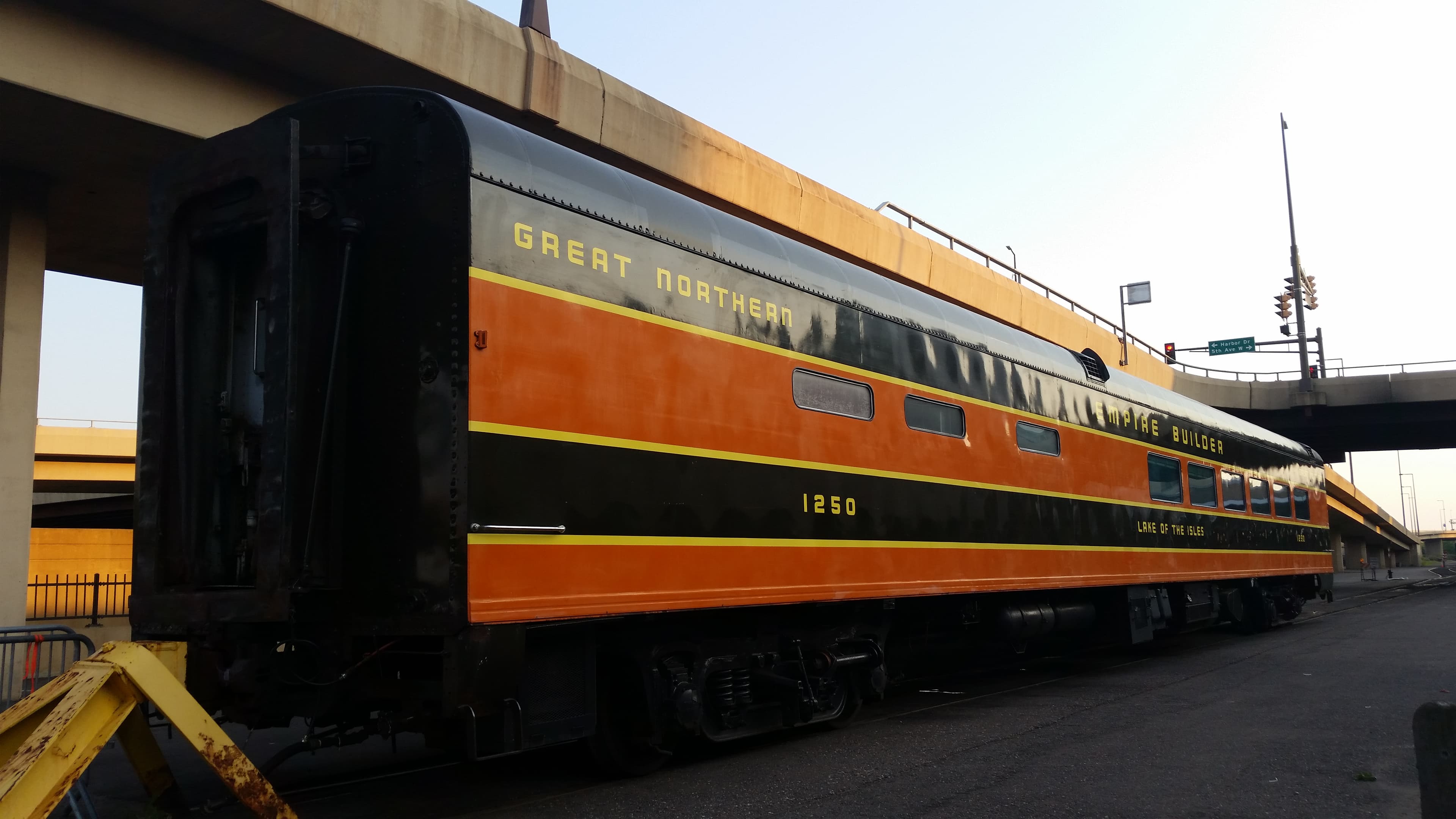
Lake Superior Railroad Museum
Duluth's Historic Union Depot houses one of America's finest rail collections, from the giant DM&IR Yellowstone to the 1861 William Crooks.
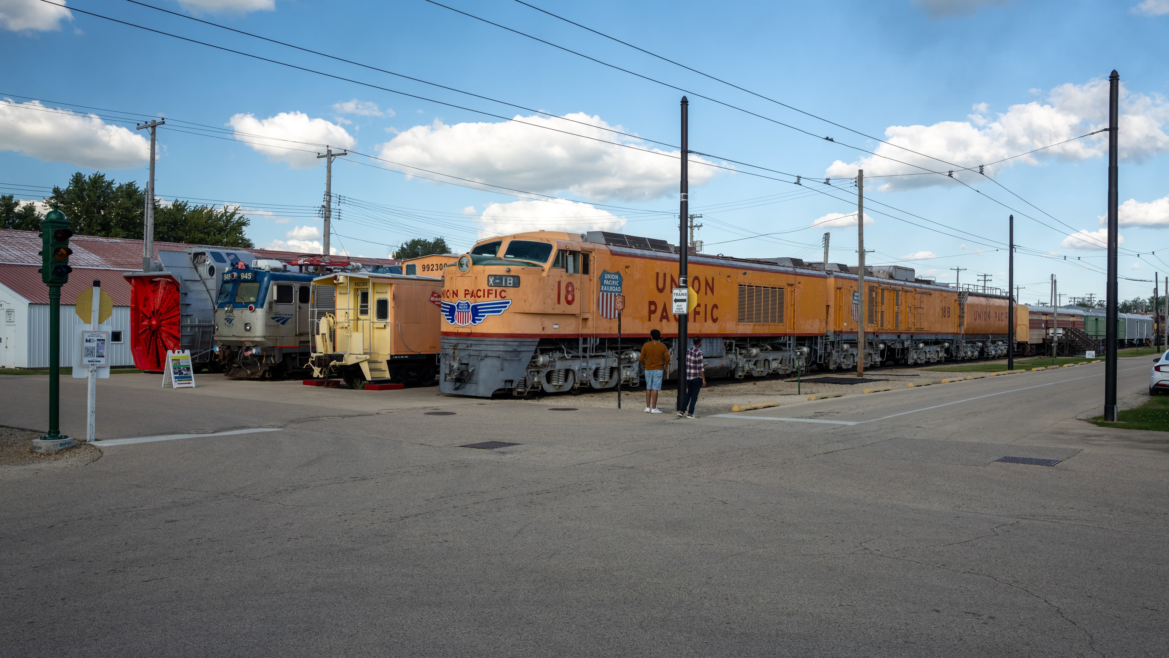
Illinois Railway Museum
The largest railroad museum in the U.S., offering vintage steam, diesel and electric train rides across a sprawling site near Chicago.
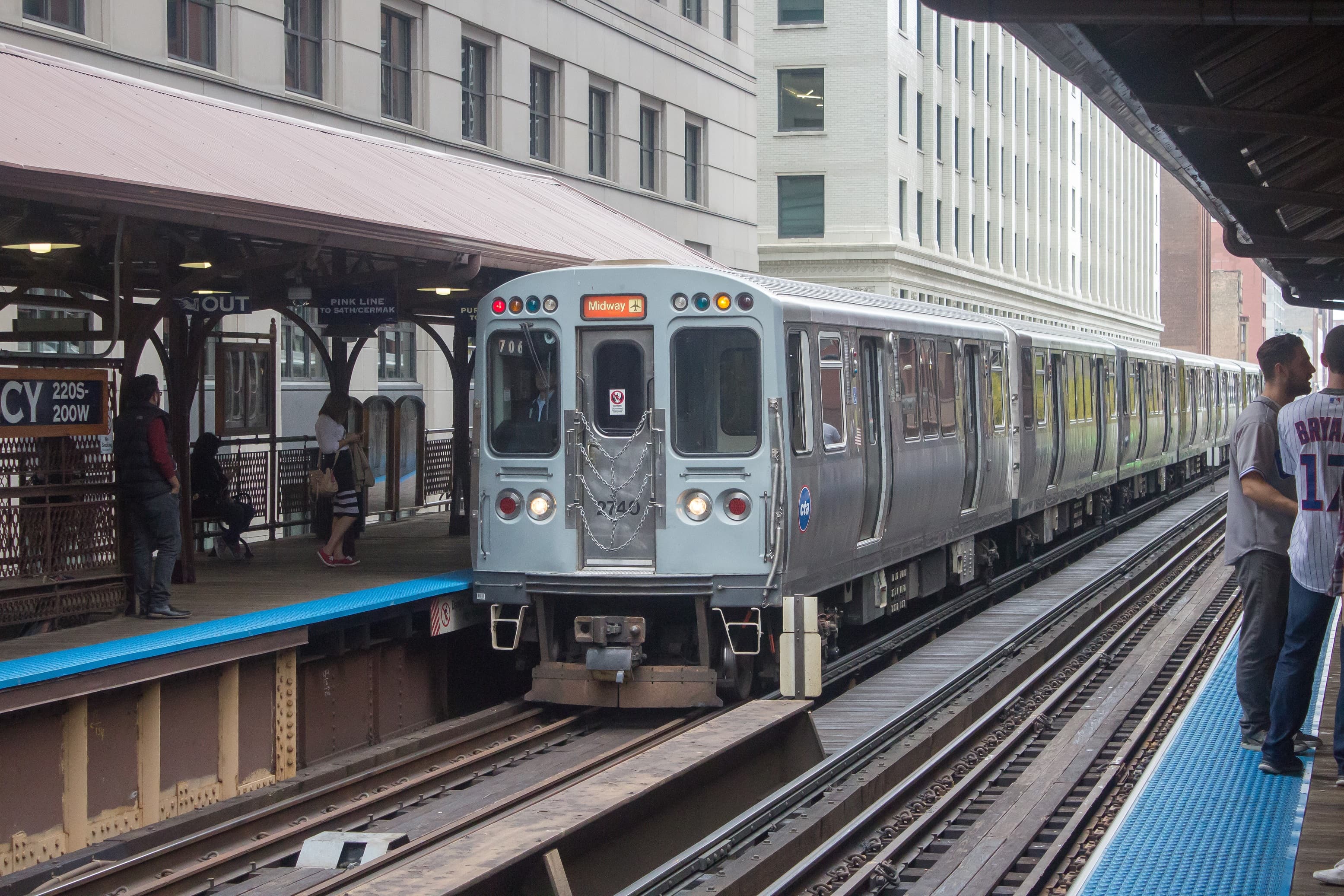
Chicago “L” (Orange Line)
An elevated Chicago “L” train line looping through downtown on viaducts, offering railfans sweeping views of the city’s skyscrapers like the Willis Tower.
Related Journeys & Mega-Projects

California Zephyr
Chicago to San Francisco across the Rockies and Sierra Nevada

Cumbres & Toltec Scenic Railroad
America's longest and highest authentic steam railroad

Strasburg Rail Road
America's oldest continuously operating standard-gauge railroad — a 45-minute steam ride through Amish farmland.
Help improve this page
Spotted something out of date or incorrect? Let our community know.
Looking for more spots? Browse the complete list of train spotting locations.
Quick Information
Country
United States
Region
Minnesota
City
Hastings
Spot Type
Urban Crossing
Best Times
Trains run around the clock. For photography, morning light (7-10 AM) illuminates eastbound movements from the Minnesota side. Mid-afternoon favors westbound shots. Peak freight windows are typically early morning and late afternoon.
Visit Duration
2-4 hours
Cost
Free
Train Activity
Train Types
Frequency
55-60 trains per day on the St. Croix Subdivision (double-tracked); joint BNSF-CPKC trackage from the junction into St. Paul
Access & Amenities
Parking
Available