

Spotting Location
San Luis Obispo (Horseshoe Curve)
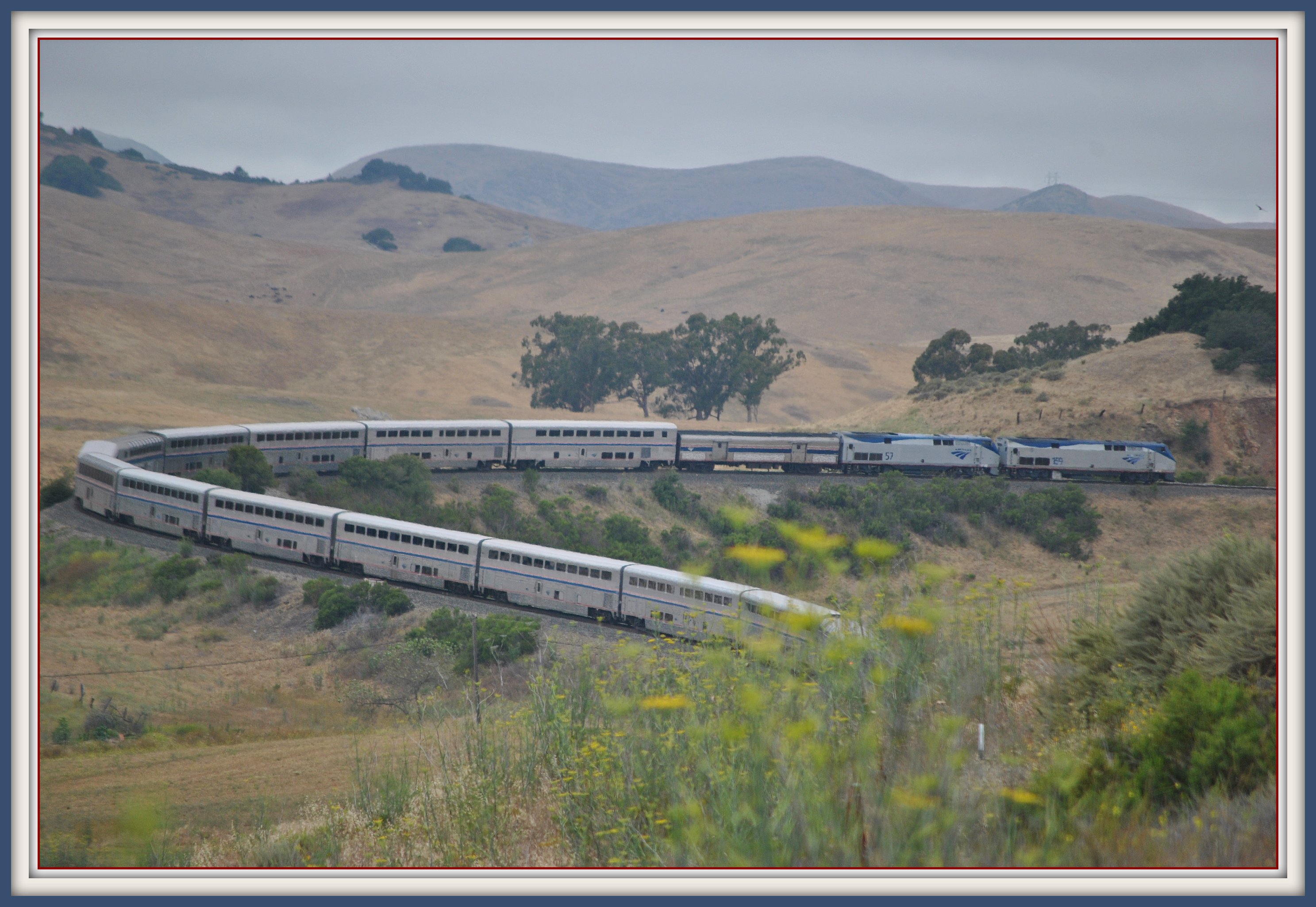
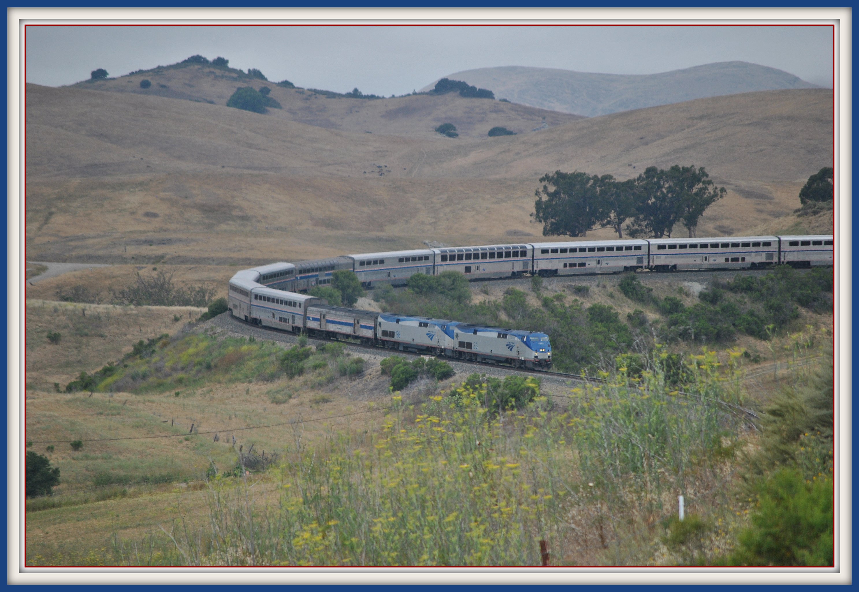
A dramatic horseshoe curve on UP's Coast Line where trains climb the steepest grade between LA and San Francisco — 2.2% through tunnels and tight curves in the Santa Lucia Range.
San Luis Obispo, California, United States
Plan your visit
Coordinates: 35.319878, -120.680591
- Parking
- None
- Shelter
- None
- Restrooms
- None
Parking: No formal parking available at the curve itself
- Best times
- Midday is typically best for the southbound Coast Starlight (Train 11). Check Amtrak schedules as times vary. Late afternoon offers warm side-lighting on northbound trains.
- Duration
- 1-3 hours
- Cost
- Free (informal access, no facilities)
Where to stand, park and take a break
Before you go — access is not guaranteed
Photo positions show where photographers have stood, not places we have visited. Some may be on private or railway property. Stay on public land and never cross fences, tracks or “No Trespassing” signs: being on railroad property is illegal and dangerous. Parking and restrooms come from official and map sources.
Read our trainspotting safety, law & etiquette guide →Tap a symbol on the map for details.
Photo spot on Stenner Creek Road
60 m south of the spot pin
Line in view: UP Coast Subdivision
Open in Google MapsPhoto spot at Goldtree
60 m north-west of the spot pin
Line in view: UP Coast Subdivision
Open in Google MapsPhoto spot at Goldtree
410 m north of the spot pin
Line in view: UP Coast Subdivision
Open in Google Maps
Take this spot with you — every point in your GPS app, even without signal.
Weather & light
Sun times calculated for this spot’s coordinates.
Seasons
Spring brings wildflowers and green hills. Summer mornings often feature coastal fog that burns off by mid-morning. Fall has golden-brown hillsides typical of California. Winter rains can make hillside access muddy and difficult. Train schedules remain consistent year-round, though the Coast Starlight can run significantly late in winter due to weather delays further north on the route.
Safety
Stay well away from the active rail line at all times. Trains on the Cuesta Grade are quieter than expected due to low speeds but can still approach without much warning, especially from tunnel portals. The hillside terrain can be steep and loose. Bring water and sun protection as there is no shade at most vantage points. Cell phone service may be spotty in the canyon.
Trains here
- Railroad
Union Pacific, Amtrak — Coast Line
- Frequency
- Approximately 4-6 Amtrak passenger trains daily (2 Coast Starlight, 2 Pacific Surfliner). Freight is rare — UP routes most through-freight via the Central Valley.
Train types
What runs here
Train activity on the Cuesta Grade is overwhelmingly passenger since Union Pacific routes nearly all through-freight via the San Joaquin Valley and Tehachapi Pass. According to Wikipedia's Coast Line article, the SLO-Santa Barbara segment saw approximately 9 freight trains per day as of 2003, but railfan accounts from the 2020s indicate freight is now very sparse on the Cuesta Grade itself — sometimes just one freight or none in a 24-hour period.
Amtrak provides the primary traffic. The Coast Starlight (Train 11 southbound, Train 14 northbound) operates one daily round trip between Seattle and Los Angeles, passing over the Cuesta Grade in each direction. Additionally, two Pacific Surfliner round trips extend to San Luis Obispo daily. All Amtrak trains are typically powered by Siemens ALC-42 Charger locomotives in push-pull configuration with bi-level Superliner (Coast Starlight) or Surfliner equipment.
When UP does send freight over the Cuesta Grade, it is typically local service or detour traffic when the valley route is disrupted. During a notable 2021 bridge replacement project near Narlon, UP detoured freight trains over Cuesta Grade, providing rare freight action on the grade.
Passenger trains on this line
- Train 14, to SeattleDaily · changed Oct 10≈ 3:12 PMestimated from San Luis Obispo, 5.7 km
- Train 11, to Los AngelesMon, Tue, Wed, Thu, Fri and Sat · changed Oct 10≈ 3:15 PMestimated from San Luis Obispo, 5.7 km
Scheduled times from Amtrak’s official timetable, updated October 4, 2026 — trains often run late. Estimated times are worked out along the line from the nearest scheduled stop.
On the line here
FRA / NTAD — crossing inventory Jul 21, 2026 · bridge inventory Oct 14, 2022 · rail yards (FRA / NTAD)
Photos & videos
 Loco Steve
Attribution License
Loco Steve
Attribution License
Swipe to see all 2 photos
Best angles for photos
The Horseshoe Curve offers several compelling angles, though reaching them requires some effort:
Inside-radius vantage: From elevated ground on the inside of the curve, a moderate wide-angle lens (35-50mm equivalent) captures the full train arcing through the horseshoe with the Santa Lucia hills as backdrop. Mid-afternoon sun illuminates westbound (descending) trains broadside.
Stenner Creek trestle: The 931-foot steel trestle (80 feet tall), built in 1904, sits just south of the Horseshoe Curve at Goldtree. Northbound trains crossing the trestle before entering the curve make for a dramatic shot, especially with a 100-200mm telephoto.
Tunnel 11 portal: Trains emerging from the 722-foot Tunnel 11 (also called Chorro Tunnel) enter the curve area. Late afternoon light hitting the locomotive nose against the dark tunnel portal creates strong contrast.
Compass direction matters here: the curve generally faces south/southwest, so morning light is behind northbound trains (good for silhouettes in fog) while afternoon light favors broadside shots of southbound movements. A polarizing filter helps cut the midday haze that builds up in this coastal canyon.
The full guide
Trainspotting Experience
The Horseshoe Curve sits on UP's Coast Line at the lower end of the Cuesta Grade, the most difficult climb on the entire route between San Francisco and Los Angeles. The grade here reaches a maximum of 2.2%, limiting speeds to 30 mph for passenger trains and 25 mph for freight. The slow speeds and tight curvature mean trains take their time wrapping through the horseshoe, giving observers an extended show.
From elevated vantage points, you can see both ends of a passenger train simultaneously as it threads through the curve — a rare sight on American railroads. The sound carries well in this canyon: locomotive horns echo off the surrounding hills, and on Amtrak trains you can hear the wheel flanges squealing against the rail. The setting is semi-rural, adjacent to the California Men's Colony, with the Stenner Creek trestle visible just south of the curve.
Access is limited and somewhat informal. There are no designated viewing platforms or parking lots at the curve itself. Most railfans hike in from nearby roads or view from elevated positions along the hillside. Respect private property boundaries and stay well clear of the active rail corridor. The area around the curve is on Union Pacific right-of-way, so do not trespass on the tracks.
Landscape, Setting & Local Atmosphere
The Cuesta Grade traverses the southern Santa Lucia Range, climbing from San Luis Obispo at 240 feet elevation to Cuesta Pass at 1,522 feet. The Horseshoe Curve sits roughly in the middle of this ascent. The surrounding terrain is classic California coastal-range hillside: coast live oaks, grey pines, and chaparral on south-facing slopes, with seasonal wildflowers — lupine and California poppies — carpeting the hills in spring.
To the southwest, several of the Nine Sisters (Morros) — a chain of volcanic peaks stretching from Morro Bay to San Luis Obispo — punctuate the skyline, including Cerro Romualdo and Chumash Peak visible from the curve area. Marine fog from the Pacific often settles in the canyon during mornings, typically burning off by mid-morning to reveal clear skies. The mild Central Coast climate keeps temperatures comfortable year-round, generally in the 60s-70s°F. In winter, the golden-brown hills turn green, and occasional storms can produce dramatic mist effects in the canyon.
Historical or Cultural Relevance
The Southern Pacific Railroad reached Santa Margarita, at the top of the Cuesta Grade, in April 1889. It then took five years and thousands of laborers using hand tools and dynamite to construct the line down to San Luis Obispo. The first SP train reached SLO on May 5, 1894 at 3:25 PM. The construction required 8 tunnels (later renumbered as some were bypassed or collapsed), the Stenner Creek trestle, and the Horseshoe Curve. The total cost was approximately $3 million in 1890s dollars — roughly $300,000 per mile — making it the most expensive section of the entire Coast Line.
The Stenner Creek trestle was completed in 1904 as a steel replacement for the original structure. At 931 feet long and 80 feet tall, it remains the longest bridge on the Coast Line. Its components were fabricated in Pittsburgh and shipped west on over 50 freight cars.
In 1987, a fire in the original timber lining of Tunnel 6 (at Cuesta Summit) closed the Coast Line for 13 days, forcing all freight onto the San Joaquin Valley route — a disruption that foreshadowed UP's eventual preference for that routing. The tunnel was repaired at a cost of $1.9 million.
San Luis Obispo served as a major SP division point where helper locomotives were added for the northbound climb. The current Amtrak station, a Mission Revival-style building, was constructed in 1943 (not 1894 as sometimes stated). Across the tracks, a restored 1940-era water tower recalls the steam era when ten passenger trains passed through SLO daily.
What Makes This Spot Different
The Cuesta Grade Horseshoe Curve is one of the few places in the western United States where you can watch an entire passenger train bend back on itself through a tight horseshoe on a steep mountain grade. The combination of 2.2% gradient, multiple tunnels, and the adjacent 931-foot Stenner Creek trestle creates a concentrated display of railroad engineering rarely found so close to a moderate-sized city.
What distinguishes this location from more famous horseshoe curves (like Altoona, PA) is the near-absence of regular freight traffic. Since UP routes through-freight via the Central Valley, the Cuesta Grade has become essentially a passenger-only mountain railroad — an unusual situation for a Class I mainline. This means the trains you'll see are primarily Amtrak's Coast Starlight and Pacific Surfliner, making timing your visit around the Amtrak schedule essential.
The broader Cuesta Grade between Santa Margarita and SLO covers 16 rail miles with a 1,000-foot elevation change, passing through six active tunnels and over the trestle. Railfans riding the Coast Starlight can experience the entire grade from the Sightseer Lounge — floor-to-ceiling windows provide a passenger's perspective of the very curves and tunnels that make this spot compelling from the outside.
Frequently Asked Questions
QHow many trains per day pass through the Horseshoe Curve?
Typically 4-6 Amtrak trains daily: two Coast Starlight trains (one each direction) and two Pacific Surfliner round trips to SLO. Freight is rare since UP routes most traffic via the Central Valley.
QCan I drive to the Horseshoe Curve?
There is no formal parking lot or viewing platform at the curve. Access is informal and requires hiking from nearby roads. The curve is adjacent to the California Men's Colony and on UP right-of-way, so stay off the tracks and respect property boundaries.
QWhat is the grade at the Horseshoe Curve?
The maximum grade on the Cuesta Grade is 2.2%, the steepest on the entire Coast Line between San Francisco and Los Angeles. Speed is limited to 30 mph for passenger trains and 25 mph for freight.
QCan I ride a train through the Horseshoe Curve?
Yes. Amtrak's Coast Starlight (Seattle-Los Angeles) and Pacific Surfliner (San Diego-SLO) both traverse the Cuesta Grade daily. The Sightseer Lounge on the Coast Starlight offers the best views.
Help improve this page
Spotted something out of date or incorrect? Let our community know.
Around San Luis Obispo
2 places on Spotatrain within 25 km of San Luis Obispo — 1 journey and 1 live cam.
- Coast Starlight 47 m
- San Luis Obispo 5.6 km
More Spots in California
Railway Experiences in the United States
Related Journeys & Mega-Projects
Nearby attractions
- San Luis Obispo Railroad Museum3.1 miles / 5 km
Located in the restored 1894 SP freight house next to the Amtrak station. Features exhibits on Coast Line history, model railroad, and railroad artifacts. Open Saturdays.
- SLO Amtrak Station & Water Tower3.1 miles / 5 km
The 1943 Mission Revival-style passenger station is still active. Across the tracks stands a restored 1940 SP water tower (65,000 gallons) — one of few surviving on the Coast Line.
- Mission San Luis Obispo de Tolosa3.7 miles / 6 km
Founded in 1772 by Father Junipero Serra, this is one of the best-preserved California missions. Located in the heart of downtown SLO.
- Stenner Creek Trestle0.6 miles / 1 km
The longest bridge on the Coast Line at 931 feet long and 80 feet tall. Built in 1904 with steel fabricated in Pittsburgh. Visible from several public vantage points near Cal Poly campus.
- Cuesta Ridge Botanical Area5 miles / 8 km
A hike from the top of Cuesta Grade offering panoramic views of the rail line, the Nine Sisters volcanic peaks, and the Pacific Ocean. Accessed via West Cuesta Ridge Road off US 101.
Hotels & places to stay near San Luis Obispo
Sources & official links
- Cuesta Pass - Wikipediaen.wikipedia.org
- Coast Line (California) - Wikipediaen.wikipedia.org
- SLO Railroad Museum - A Five-year Wait for the Trainslorrm.com
- Cuesta Pass Railroading: Return of Freight - Jake Miille Photographyjakemiillephotography.com
- Stenner Creek Trestle - Corvid Sketchercorvidsketcher.com
- San Luis Obispo Amtrak Station - Great American Stationswww.greatamericanstations.com
- Pacific Surfliner Scheduleswww.pacificsurfliner.com
- Amtrak Coast Starlight - Wikipediaen.wikipedia.org