

Spotting Location
Cajon Pass (Summit)
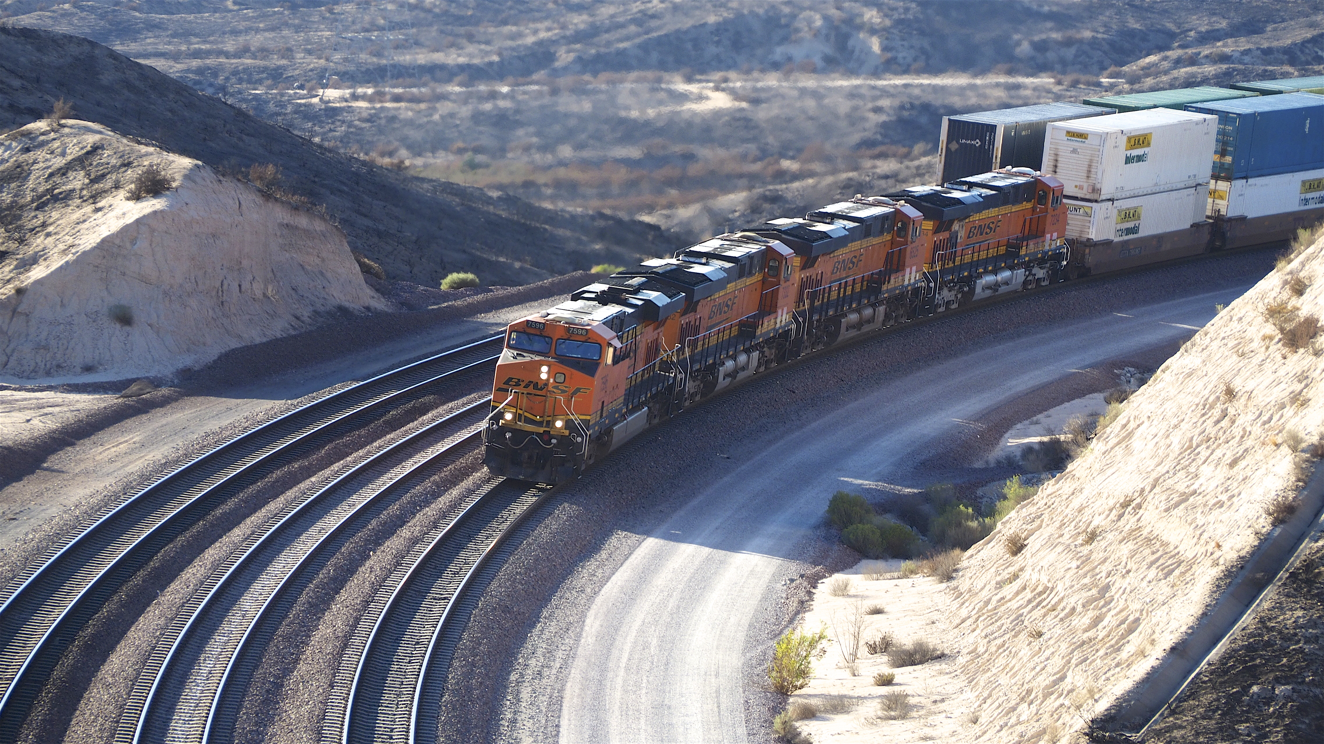
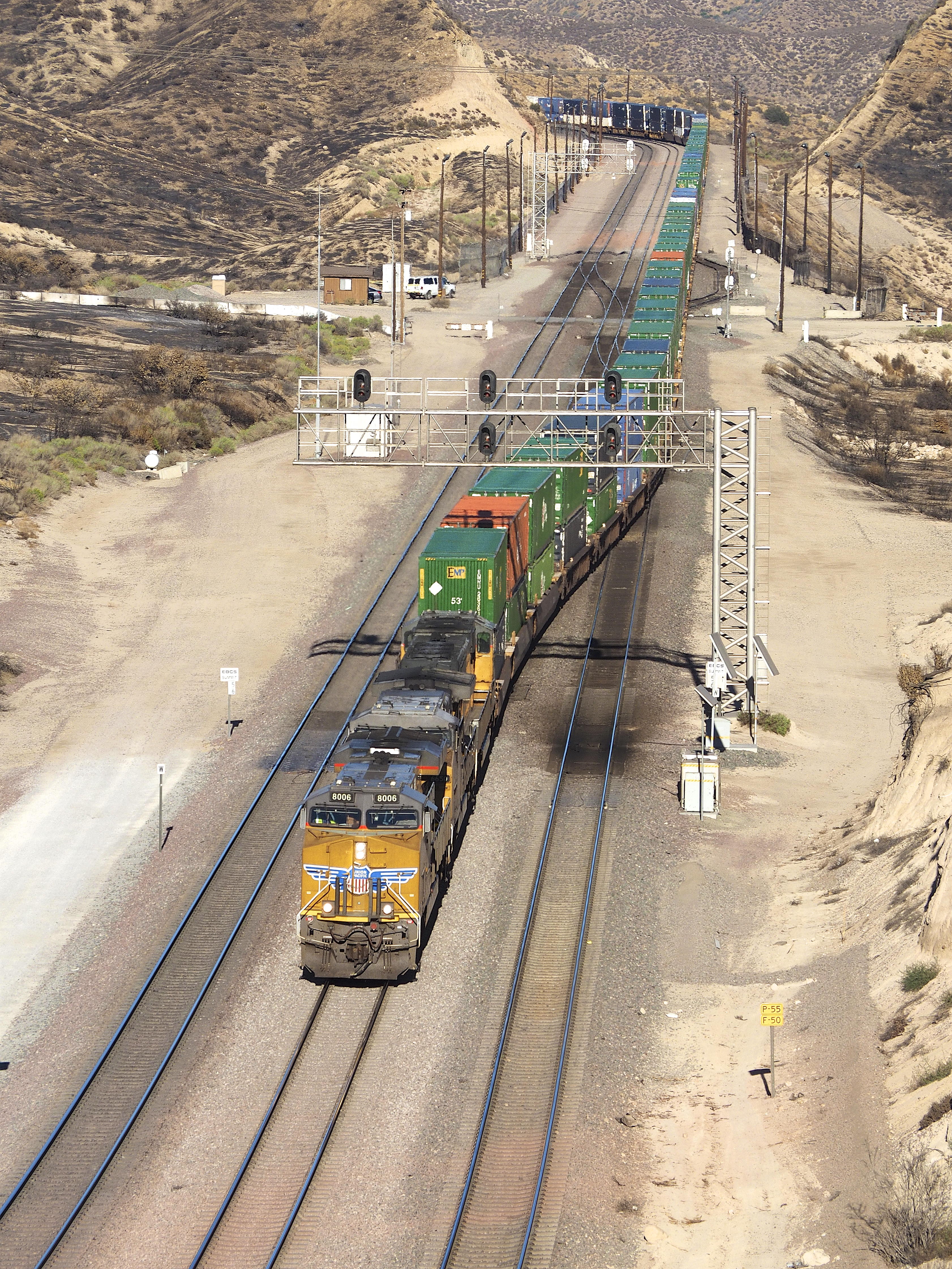
The busiest mountain railroad crossing in the United States, where BNSF's triple-track Cajon Subdivision and Union Pacific's Palmdale Cutoff funnel roughly 90 trains per day through a dramatic desert canyon between the San Bernardino and San Gabriel Mountains.
Hesperia, California, United States
Plan your visit
Coordinates: 34.325590, -117.430309
- Parking
- Free
- Shelter
- None
- Restrooms
- Yes
Parking: Free — informal dirt pullouts at Hill 582 and along Forest Service roads. The USFS Summit Scenic Overlook on Highway 138 has a small unpaved parking area.
- Best times
- Trains run 24/7, but daylight hours offer the best viewing. Early morning (sunrise to 10 AM) provides excellent warm light on eastbound trains climbing the grade. Late afternoon golden hour backlights westbound stacks against the Mojave sky. Traffic tends to be heavier later in the week. The Amtrak Southwest Chief passes in early morning and late evening.
- Duration
- 2-6 hours (minimum 2 hours to appreciate the traffic volume; many railfans spend a full day)
- Cost
- Free access. No entrance fees or Adventure Pass required.
Where to stand, park and take a break
Before you go — access is not guaranteed
Photo positions show where photographers have stood, not places we have visited. Some may be on private or railway property. Stay on public land and never cross fences, tracks or “No Trespassing” signs: being on railroad property is illegal and dangerous. Parking and restrooms come from official and map sources.
Read our trainspotting safety, law & etiquette guide →Tap a symbol on the map for details.
Photo spot on Rim of the World Scenic Byway
at the spot pin
Line in view: BNSF Cajon Subdivision
Open in Google MapsPhoto spot near Rim of the World Scenic Byway
140 m west of the spot pin
Line in view: BNSF Cajon Subdivision
Open in Google MapsPhoto spot on Rim of the World Scenic Byway
210 m east of the spot pin
Line in view: BNSF Cajon Subdivision
Open in Google MapsPhoto spot near Rim of the World Scenic Byway
390 m east of the spot pin
Line in view: BNSF Cajon Subdivision
Open in Google MapsPhoto spot on Summit Road
710 m east of the spot pin
Line in view: BNSF Cajon Subdivision
Open in Google MapsPhoto spot near Old Hesperia Road
1.6 km north-west of the spot pin
Line in view: BNSF Cajon Subdivision
Open in Google MapsPhoto spot near Southern Pacific Road
2.4 km west of the spot pin
Line in view: BNSF Cajon Subdivision
Open in Google Maps
Take this spot with you — every point in your GPS app, even without signal.
Weather & light
Sun times calculated for this spot’s coordinates.
Seasons
Year-round destination. Spring (March-May) and fall (September-November) offer the most comfortable temperatures and clearest skies. Summer brings intense heat (often exceeding 100F) and afternoon heat haze that distorts telephoto shots, but longer daylight hours compensate. Winter can bring occasional snow dustings above the pass creating dramatic backdrops, though dirt road access to Hill 582 may be muddy after rain. Santa Ana wind events (October-November) can be uncomfortable but produce exceptionally clear air once winds subside.
Safety
Stay on public USFS roads and respect railroad property boundaries — Summit is fenced and guarded, and BNSF security actively patrols. Never walk on or cross the tracks. Hill 582 requires a high-clearance vehicle on dirt roads; conditions deteriorate after rain. The Highway 138 overlook is at a cliff edge. Bring plenty of water, sunscreen, and wind protection year-round. Rattlesnakes are present in warm months. Cell service is spotty in some areas. Report suspicious activity to BNSF: 1-800-832-5452.
Trains here
Through trains per day
52reported to the FRA
Daytime
26
6 AM – 6 PM
≈ 1 every 28 min
Nighttime
26
6 PM – 6 AM
≈ 1 every 28 min
Reported by the railroad for FRA grade crossing 945571F, 710 m from this spot (FRA inventory, July 2026). An estimate, not a schedule — crossings on this line within 5 km report 10 to 52.
- Railroad
BNSF, Union Pacific — Cajon Subdivision
≈ MP 56 on the Cajon Subdivision — derived from FRA grade crossing 945571F, 710 m away
- Track at the crossing
- 3 main tracks · 55 mph timetable speed
Train types
What runs here
Both BNSF Railway and Union Pacific use Cajon Pass as a primary gateway between Southern California ports and the rest of the nation. BNSF’s Cajon Subdivision—three main tracks—handles an average of 65–75 trains per 24 hr, heavily weighted toward double-stack intermodal, manifest freight, autoracks, and ethanol or crude oil unit trains. Union Pacific’s Mojave Subdivision adds roughly 20–25 trains daily, including northbound stack trains bound for the Central Valley and Nevada, as well as rock and military movements from the nearby Marine Corps Logistics Base. Passenger action is limited but notable: Amtrak’s Southwest Chief glides over the pass once each direction in the early morning and late evening, its Superliner cars providing a welcome splash of color amid the freight parade.
Passenger trains on this line
- Train 3, to Los AngelesDaily · changed Oct 5–9≈ 4:29 AMestimated from Victorville Amtrak, 31 km
- Train 4, to ChicagoDaily≈ 7:21 PMestimated from Victorville Amtrak, 31 km
Scheduled times from Amtrak’s official timetable, updated October 5, 2026 — trains often run late. Estimated times are worked out along the line from the nearest scheduled stop.
On the line here
FRA / NTAD — crossing inventory Jul 21, 2026 · rail yards (FRA / NTAD)
Watch this spot live
A railway webcam covers this location — see what is running right now.
- Watch live
Cajon Pass, California — Summit and Silverwood
BNSF's triple-track climb over Cajon Summit
Photos & videos
 Clay Gilliland
Attribution-ShareAlike License
Clay Gilliland
Attribution-ShareAlike License

jpmueller99
4

jpmueller99
4

Morten Jensen
4
Swipe to see all 5 photos
Best angles for photos
Hill 582 (GPS: N 34.33343, W 117.45536) is the premier location, offering elevated views of all four tracks. In winter, it provides all-day light on trains; in summer, morning and afternoon work best. A wide-angle lens captures the dramatic convergence of multiple tracks, while a 200-300mm telephoto compresses the S-curves stretching toward the High Desert. From the hilltop, you can shoot both uphill and downhill trains on BNSF mains 1, 2, and 3 plus the UP Palmdale Cutoff.
The Highway 138 overlook (USFS Summit Scenic Overlook) has a small unpaved parking area on the north side and offers head-on views of trains cresting the grade. Best lit mid-morning to early afternoon. The viewpoint is at the edge of a cliff — exercise caution.
Sullivan's Curve (GPS: N 34.29914, W 117.47364), lower in the pass, provides classic sweeping curve shots with Mormon Rocks as a backdrop. Accessible via Cajon Boulevard (old Route 66) from the Kenwood Avenue or Cleghorn Road exits off I-15.
Morning light favors eastbound trains climbing from San Bernardino. Golden hour produces dramatic silhouettes of westbound stacks. Night photography is productive here due to minimal light pollution — long exposures capture trains streaking beneath desert stars.
The full guide
Trainspotting Experience
Cajon Pass Summit is a pilgrimage for serious railfans — one of the few places in North America where you can watch two Class I railroads operate four main tracks through a steep mountain corridor, all from public viewpoints within yards of the ballast. Access is via Forest Service roads that parallel the right-of-way off California Highway 138 and Summit Valley Road. From various pullouts, you can stand close enough to feel the ground shake as trains grind upgrade at 14 to 22 mph or descend using dynamic brakes at 20 to 30 mph.
The iconic viewing spot is Hill 582, an unofficial railfan overlook named for its USGS elevation contour. Maintained by volunteers who planted shade trees and installed benches, Hill 582 provides commanding views of all three BNSF main tracks and UP's Palmdale Cutoff simultaneously. On a good day, you can spot approaching headlights miles away, giving ample setup time. Expect mostly GE ES44C4s and EMD SD70ACes leading trains that routinely stretch beyond 10,000 feet. BNSF ended regular manned helper service in October 2009, switching to distributed power, though UP still maintains one helper pool.
Note that Summit itself is fenced, lit, and guarded by security. BNSF's Citizens for Rail Security program means private security patrols the area regularly. Stay on public Forest Service roads and respect railroad property boundaries. A high-clearance vehicle is recommended for reaching Hill 582 via the dirt access roads.
Landscape, Setting & Local Atmosphere
Summit sits at 3,777 feet elevation (reduced from 3,829 feet after AT&SF's 1972 realignment project that also eased curves from 10 to 4 degrees) at the transition between chaparral-covered slopes and high-desert scrub. The pass was carved by the San Andreas Fault, which runs directly through the area — Mormon Rocks, a striking white sandstone formation visible from Highway 138, marks the fault zone.
Joshua trees and scattered pinyon pine frame rail shots against tawny ridges. In winter, the peaks of the San Gabriel Mountains carry snow, adding contrast to the desert foreground. Visibility often exceeds 50 miles on clear days, though summer afternoons bring heat haze that distorts telephoto shots. The pass is notorious for wind — Santa Ana season (October through November) can bring gusts exceeding 60 mph, strong enough to topple trucks on nearby I-15. The area sits within the San Bernardino National Forest, a 676,000-acre preserve established in 1907. Spring and autumn offer the most comfortable shooting conditions with crisp light and moderate temperatures.
Historical or Cultural Relevance
The original single-track Santa Fe line opened through Cajon Pass in 1885, effectively linking Los Angeles with the rest of the United States. A second track followed in 1913 to handle booming citrus and oil traffic. Southern Pacific (now UP) completed its Palmdale Cutoff in 1967, giving SP a lower-grade route to the ports and introducing competitive drama still felt today. BNSF’s 2008 third mainline project at Summit eliminated a decades-old bottleneck and stands as one of the largest recent capacity upgrades in U.S. mountain railroading. Artifacts of earlier eras—abandoned telegraph poles, concrete mileposts, and foundation remnants of helper-station cabins—dot the hillsides, silently narrating 140 years of rail history.
What Makes This Spot Different
Cajon Pass is widely regarded as the busiest railroad mountain crossing in the United States. With BNSF's $90-million third main track (completed November 3, 2008, adding nearly 16 miles of track and increasing theoretical capacity from 100 to 150 trains per day), the pass handles an extraordinary volume and variety of traffic. Few locations offer simultaneous views of four main tracks operated by two competing Class I railroads.
The accessibility sets Cajon apart — public Forest Service roads and Highway 138 viewpoints bring you within arm's reach of mainline action, unlike many remote mountain passes that require long hikes. The constant flow (a train roughly every 10-15 minutes during peak periods) means minimal downtime. The mix includes double-stack intermodal, manifest freight, autoracks, unit grain and oil trains, and Amtrak's Southwest Chief — providing variety that keeps every hour interesting.
The pass is also evolving: Brightline West high-speed rail is under construction through Cajon Pass as part of the Las Vegas to Rancho Cucamonga route following the I-15 corridor, adding another chapter to over 140 years of railroading history through this gap in the mountains.
Frequently Asked Questions
QHow many trains per day pass through Cajon Pass?
Approximately 90 or more trains per day. BNSF averages about 70 trains daily on its three main tracks, Union Pacific averages about 20 on the Palmdale Cutoff, and Amtrak Southwest Chief runs once in each direction daily.
QHow do I get to Hill 582?
From Highway 138, take the dirt Forest Service roads south toward the BNSF tracks. A high-clearance vehicle is strongly recommended. Use GPS coordinates N 34.33343, W 117.45536. Access is via Powerline Road, approximately 2.3 miles east of the I-15/Highway 138 interchange.
QIs it safe to visit Cajon Pass for trainspotting?
Yes, as long as you stay on public Forest Service roads and never walk on railroad property. Summit itself is fenced, guarded, and off-limits. BNSF security patrols regularly. Bring water, sun protection, and be aware of rattlesnakes in warm months.
QWhat radio frequencies should I monitor at Cajon Pass?
BNSF: 161.190 MHz (AAR 72) San Bernardino to Hodge, 160.085 MHz (AAR 4) Hodge to Barstow. UP: 160.740 MHz (AAR 42) Colton to Hiland, 160.320 MHz (AAR 14) Hiland to Bakersfield. BNSF and UP dispatchers work from a joint facility in San Bernardino.
QWhen does Amtrak pass through?
The Southwest Chief runs daily between Chicago and Los Angeles, passing through Cajon Pass in the early morning (westbound to LA) and late evening (eastbound to Chicago). Check Amtrak schedule for current times.
Help improve this page
Spotted something out of date or incorrect? Let our community know.
Around Hesperia
3 places on Spotatrain within 25 km of Hesperia — 1 spot, 1 mega-project and 1 live cam.
- Cajon Pass, California — Summit and Silverwood 338 m
- Brightline West 3.1 km
- Sullivan's Curve 4.9 km
Spots Near Hesperia
More Spots in California
Related Experiences
Related Journeys & Mega-Projects
Nearby attractions
- Mormon Rocks / San Andreas Fault Interpretive Trail3.1 miles / 5 km
Striking white sandstone formations along the San Andreas Fault, visible from Highway 138. Short interpretive trail with views of trains winding through the pass below.
- San Bernardino History & Railroad Museum18.6 miles / 30 km
Located in the restored 1918 Santa Fe Depot, this museum houses the Santa Fe Western Archives and railroad memorabilia. Over 100 freight trains pass the depot daily. Open Saturdays.
- California Route 66 Museum15.5 miles / 25 km
Free museum in Old Town Victorville celebrating Route 66 history, housed in the 1930s-era Red Rooster Cafe. Exhibits include railroad history alongside highway heritage.
- Silverwood Lake State Recreation Area6.2 miles / 10 km
Scenic reservoir located just northeast of the pass, offering fishing, boating, hiking, and camping with mountain views. Good for a half-day break from railfanning.
- Southern California Railway Museum (Perris)46.6 miles / 75 km
The West's largest railway museum with 200+ historic vehicles including Pacific Electric Red Cars. Ride vintage trains and trolleys on weekends. About 1 hour south via I-215.
Hotels & places to stay near Hesperia
Sources & official links
- Wikipediaen.wikipedia.org
- Trains.comwww.trains.com
- USFS Summit Scenic Overlook - San Bernardino National Forestwww.fs.usda.gov
- Santa Fe Railway Historical & Modeling Society - Cajon Passsfrhms.org
- Hill 582 History by Don E. Toles (Trainmaster.ch)trainmaster.ch
- San Bernardino History & Railroad Museumwww.sbrhs.org
- Railfan's Guide to Cajon Pass by Al Bowen (TrainWeb)trainweb.us
- North American Rails - Cajon Pass Railfan Guidewww.northamericanrails.com
- Railfanguides.us - Cajon Pass Fact Sheetwww.railfanguides.us
- Cajon Pass History & Railroad Grade - American-Rails.comwww.american-rails.com