Spotting Location
Carlin (Humboldt Canyon)
Where the Humboldt River carves through steep canyon walls, Union Pacific's dual-track Elko Subdivision threads tunnels and bridges on the historic transcontinental corridor — one of Nevada's most dramatic railroad settings.
Updated
Photos
No photos yet — be the first to share one!
Trainspotting Experience
Carlin Canyon offers a rare combination of canyon scenery and heavy mainline railroading. Two parallel Union Pacific main tracks — the former Southern Pacific (westbound) and former Western Pacific (eastbound) — run through the canyon along the Humboldt River, passing through the Carlin Tunnel complex. Access is via I-80 Exit 282 (East Carlin), then south on Chestnut Street, which becomes a frontage road running parallel to I-80 on the south side. After about 3.5 miles, Chestnut Street curves under I-80 and enters the canyon itself.
Inside the canyon, there are two graveled parking areas at each end, with a few small turnouts along the road. The western parking area offers afternoon shade. The road surface is paved, making access straightforward for any vehicle. Scanner frequencies for the Elko Subdivision can be found on RadioReference.com. Trains announce themselves well in advance — horn echoes carry effectively through the canyon walls, giving ample warning to set up for photos. Wind can be strong through the canyon corridor, so secure gear accordingly. Summer temperatures can exceed 95 F, with little shade available, while winter brings sub-freezing mornings with clear, crisp air.
Landscape, Setting & Local Atmosphere
The canyon sits at approximately 4,900 feet elevation in classic Basin-and-Range country. The Humboldt River, one of the longest rivers in the Great Basin, has carved steep-sided walls of Paleozoic limestone through this stretch, creating a natural corridor that has channeled transportation routes since the 1840s California Trail era. Buff and rust-colored rock faces rise sharply on both sides, with scattered pinon pine, juniper, and sagebrush covering the slopes.
The Humboldt River threads through the canyon floor, its cottonwood-lined banks providing a rare strip of green in the surrounding arid landscape. The canyon's geology is notable — researchers from the University of Nevada have studied the exposed Mississippian-Pennsylvanian and Permian rock formations visible in the canyon walls. Between trains, the canyon is remarkably quiet; the remoteness of northeastern Nevada means minimal light pollution, and the dark skies have drawn attention from astronomers and campers alike.
Type & Frequency of Train Activity
Carlin sits on Union Pacific's Elko Subdivision, which carries both the Overland Route and Central Corridor. This is a dual-track mainline with an unusual operational arrangement: the northern track (ex-Southern Pacific, originally Central Pacific from 1868) handles westbound traffic, while the southern track (ex-Western Pacific, built 1906-1909) handles eastbound traffic. This directional running setup was formalized during World War I under the US Railroad Administration and has continued ever since.
The traffic mix is overwhelmingly freight: intermodal stack trains from West Coast ports, manifest freight, and unit trains of various commodities. BNSF Railway holds trackage rights across this corridor, obtained as a condition of the 1996 UP-SP merger. Amtrak's California Zephyr (Chicago-Emeryville) traverses this route, though the schedule puts it through the Carlin area during overnight hours, making passenger sightings unlikely. The corridor is a key link in UP's transcontinental network, connecting Northern California with Salt Lake City and points east.
Best Angles for Photos & What Railfans Enjoy Most
The canyon provides several distinct vantage points. From the frontage road inside the canyon, photographers can shoot at near track level with the canyon walls as a dramatic backdrop. The graveled parking areas at each end of the canyon offer stable footing for tripods. Westbound trains (on the ex-SP track) cross the Humboldt River at both portals of the Carlin Tunnel, providing bridge-and-tunnel compositions.
Morning light illuminates eastbound train faces emerging from the canyon, while late afternoon light creates warm tones on the limestone walls behind westbound trains. A 70-200mm lens covers most compositions from trackside; wider angles (24-35mm) can capture the full canyon setting with trains as context. The hill above the Carlin Tunnel offers an elevated perspective — a 360-degree panorama from this vantage point has been widely shared online. Sunset can produce dramatic light effects on the canyon walls and reflections in the river during spring runoff.
Historical or Cultural Relevance
Carlin Canyon has been a transportation corridor for nearly two centuries. The California Trail brought emigrant wagon trains through beginning in the 1840s, including the ill-fated Reed-Donner Party in September 1846. Central Pacific Railroad's Chinese track crews constructed the transcontinental railroad through the canyon in December 1868, and the town of Carlin was established as a division terminal with machine shops and a roundhouse.
The Southern Pacific Railroad (successor to Central Pacific) built the first Carlin Tunnel in 1903 to straighten the route by bypassing a sharp river bend. The Western Pacific Railroad constructed its competing line through the canyon between 1906 and 1909. The two Interstate 80 highway bores were completed in 1975 at a cost of $8 million — then the most expensive single contract awarded by the Nevada Department of Highways.
The canyon was the scene of a notable 1908 rock slide that nearly collapsed the SP tunnel, and in 1939, the streamliner City of San Francisco derailed on a Humboldt River bridge in nearby Palisade Canyon, killing 24 people in what remains Nevada's worst railroad disaster. Union Pacific honored Carlin as a Train Town USA in July 2024 during a whistle-stop with Big Boy No. 4014.
What Makes This Spot Different
Carlin Canyon stands apart from other Nevada railfan locations because of its rare vertical drama — while most of the state's railroad runs across open sagebrush valleys, here the tracks are hemmed between river and rock walls. The dual-track directional running arrangement is itself unusual: each track was built by a different competing railroad decades apart, and trains in the eastern half of the Elko Subdivision observe right-hand traffic while those in the western half observe left-hand traffic.
The four-bore Carlin Tunnel complex (two railroad, two highway) is unique in the American West, and the canyon serves as a convergence point for multiple historic transportation routes: the California Trail, the first transcontinental railroad, the Victory Highway, US Route 40, and Interstate 80. Free dispersed camping is available in the canyon on BLM land, making overnight trainwatching sessions practical — a rarity for major mainline locations.
Frequently Asked Questions
QHow do I access Carlin Canyon?
Take I-80 Exit 282 (East Carlin) and head south onto Chestnut Street. Follow this frontage road for about 3.5 miles as it curves under I-80 and enters the canyon. Two graveled parking areas are available.
QCan I camp in Carlin Canyon?
Yes, free dispersed camping is available on BLM land within the canyon. There are two main graveled camping areas, one at each end of the canyon. There are no facilities — bring everything you need.
QWhat railroad operates through the canyon?
Union Pacific operates both main tracks through the canyon as part of the Elko Subdivision. The northern track (ex-Southern Pacific) carries westbound traffic and the southern track (ex-Western Pacific) carries eastbound traffic. BNSF also has trackage rights.
QHow many tunnels are in Carlin Canyon?
The Carlin Tunnel complex has four bores: two carry railroad traffic (one ex-SP from 1903, one ex-WP from 1906-1909) and two carry Interstate 80 (completed 1975). Additional smaller tunnels exist further along the canyon.
QIs the California Zephyr visible here?
Amtrak California Zephyr passes through the canyon, but its schedule typically puts it through the Carlin area during overnight hours, making sightings unlikely without an overnight stay.
Safety Tips
Stay well clear of the active railroad tracks — this is a busy mainline. Be aware of canyon wind gusts that can affect tripods and equipment. Summer heat is severe; carry extra water. Cell service is unreliable in the canyon. Watch for rattlesnakes in warmer months.
Seasonal Information
Summer (June-August) brings temperatures above 95 F with intense sun and little shade — bring ample water. Fall (September-October) offers comfortable temperatures and golden cottonwood foliage along the river. Winter brings sub-freezing mornings but crystal-clear air for long-lens photography; light snow can accent the canyon walls. Spring (April-May) features higher river flows creating reflections and occasional wildflower blooms.
Nearby Lodging
Find places to stay near Carlin (Humboldt Canyon).
This lodging map is provided by Stay22, a third-party service that may set cookies. It loads only with your consent.
Accommodation results are provided by Stay22; we may earn a commission on bookings made through this map.
Nearby Attractions
10 miles / 16 km
Free BLM museum with immersive exhibits, life-size dioramas, and hiking trails exploring the 2,000-mile emigrant journey to California. Open Wednesday-Sunday, 8:30am-5pm.
3.1 miles / 5 km
Nature walk and fishing pond developed on the site of historic Chinese immigrant vegetable gardens from the railroad construction era.
23 miles / 37 km
Museum in Elko with exhibits on pioneer life, Pony Express riders, Basque settlers, and mining history. Features a Halleck Station exhibit.
199 miles / 320 km
National Historic Landmark and operating heritage railroad in Ely with original steam locomotives from 1910. Offers 90-minute excursion rides, photography workshops, and Be the Engineer experiences.
23 miles / 37 km
Cultural center in Elko featuring exhibits on cowboy and ranching heritage, plus the Wiegand Gallery art collection. Home of the National Cowboy Poetry Gathering.
Official Resources
Related on Spotatrain
Spots Near Carlin
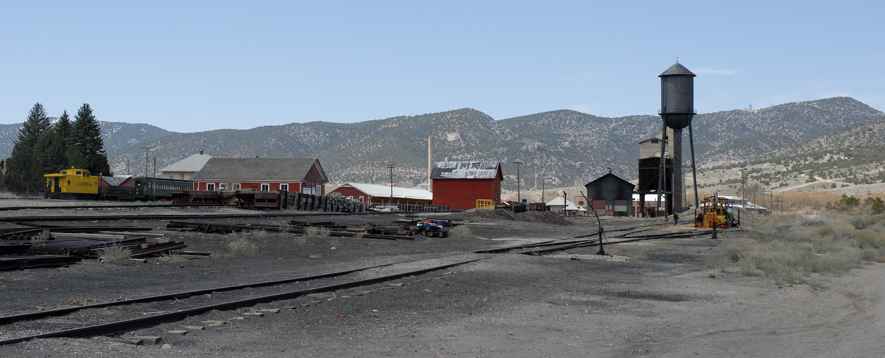
Ely (Nevada Northern)
The Nevada Northern Railway Museum in East Ely preserves one of the most complete steam-era railroad complexes in North America. This National Historic Landmark features 70+ original buildings, 30 miles of track, and century-old steam and diesel locomotives on a 56-acre campus.

Reno (Sparks Yard)
Union Pacific's key Overland Route yard in Sparks, Nevada — a historic division point since 1904, offering close public viewing of freight operations, crew changes, and the daily California Zephyr against a Sierra Nevada backdrop.
Ogden (Union Station)
Historic 1924 Spanish Colonial Revival depot at the west end of Ogden's 25th Street, where UP's Evanston Subdivision main line carries 45-50 trains daily past the Utah State Railroad Museum and active FrontRunner commuter rail station.
Echo Canyon (UP)
Union Pacific's Evanston Subdivision cuts through Echo Canyon's red Triassic sandstone on the original transcontinental route, with 50-60 trains daily visible from the I-80 Welcome Center and pull-offs along Echo Canyon Road.
Truckee (Donner Pass)
Downtown Truckee depot (10065 Donner Pass Rd) places railfans steps from the Union Pacific Overland Route at 5,820 ft elevation, where 15 to 25 daily freight trains and two Amtrak California Zephyr calls pass through the Sierra Nevada. The 1900 Southern Pacific stone depot and the nearby historic Summit Tunnel hiking trail make this a premier California railfan destination.
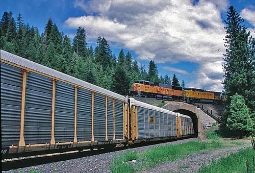
Williams Loop (Feather River)
Williams Loop is a one-mile rail spiral on Union Pacific's Feather River Route in Plumas County, where the track crosses over itself to gain 65 feet of elevation on the 1% grade to Beckwourth Pass. Built in 1914 by the Western Pacific Railroad, it is one of North America's most photographed trainspotting sites — roadside pullouts along Highway 70 give an elevated view of an entire freight train encircling itself.
Related Experiences
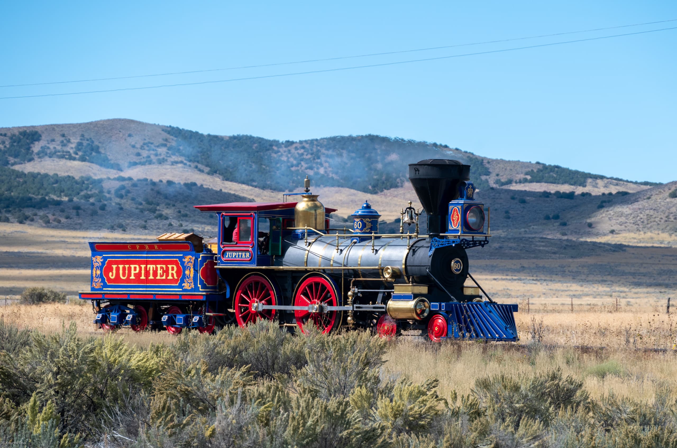
Golden Spike National Historical Park
Promontory Summit site where the first transcontinental railroad was completed in 1869, with working replica steam locomotives Jupiter and No. 119.
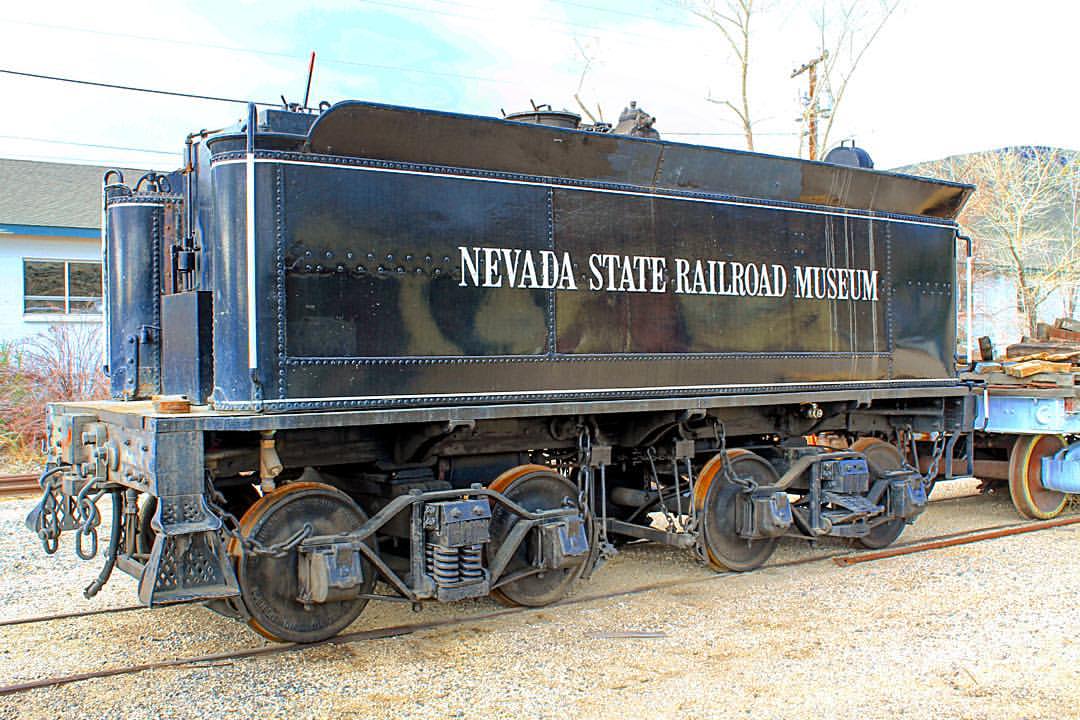
Nevada State Railroad Museum, Carson City
Home of Virginia & Truckee Railroad locomotives and the world's only operable McKeen motor car, in Carson City, Nevada.
California State Railroad Museum
A world-class railroad museum in Old Sacramento featuring historic locomotives, rail cars, and immersive exhibits that bring California’s railroading past to life.
Related Journeys & Mega-Projects

California Zephyr
Chicago to San Francisco across the Rockies and Sierra Nevada

Brightline West
America's first true high-speed rail: Las Vegas to greater Los Angeles at 200 mph

Grand Canyon Railway
A 65-mile heritage train journey from Williams, Arizona to the South Rim of the Grand Canyon
Help improve this page
Spotted something out of date or incorrect? Let our community know.
Looking for more spots? Browse the complete list of train spotting locations.
Quick Information
Country
United States
Region
Nevada
City
Carlin
Spot Type
Scenic Overlook
Best Times
Train traffic runs around the clock. Morning and late afternoon offer the best photographic light. The canyon can be extremely hot in summer afternoons.
Visit Duration
1-3 hours
Cost
Free
Train Activity
Train Types
Access & Amenities
Parking
Available (Free — BLM dispersed parking areas)
Shelter
Not available
Restrooms
Not available