Spotting Location
Devils Lake (Causeway)
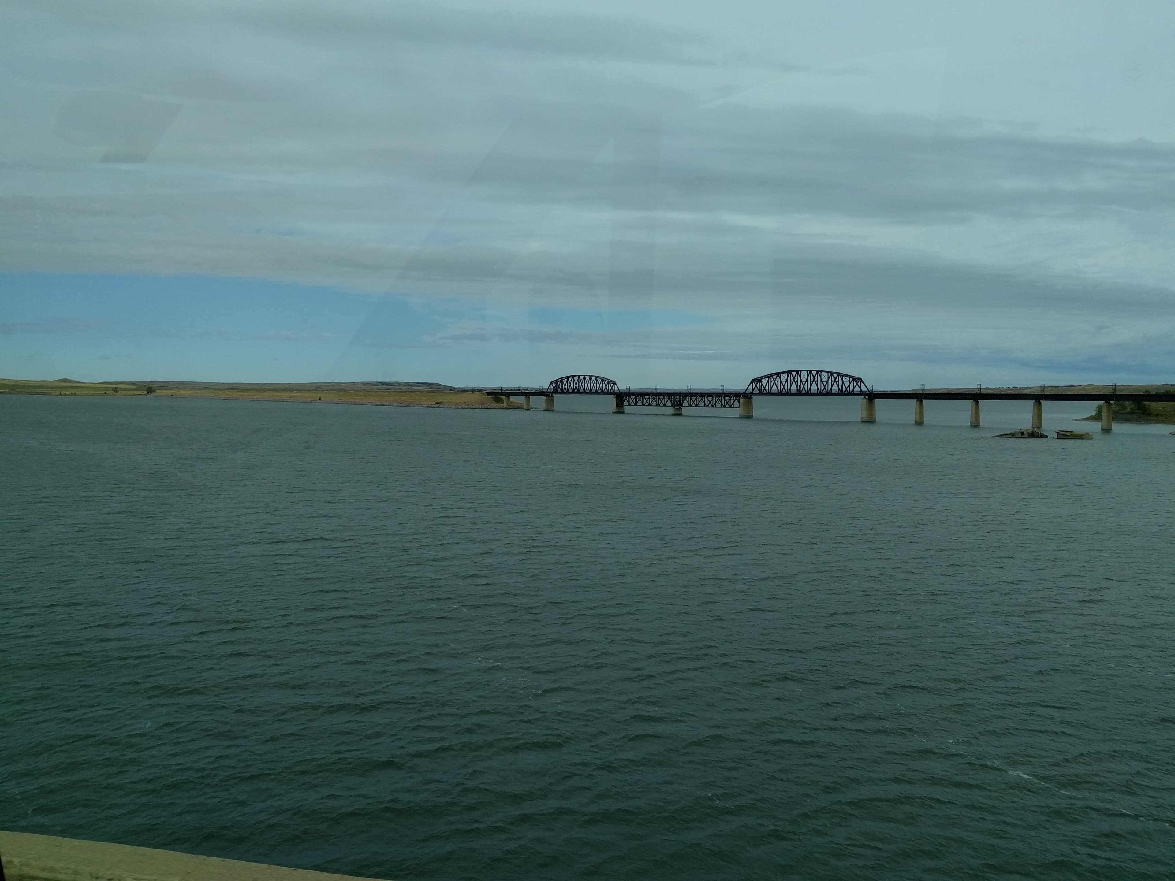
A dramatic rail crossing where BNSF's Northern Transcon route traverses a raised embankment through the flood-expanded waters of Devils Lake, North Dakota's largest natural lake. The $100 million track raise project makes this a compelling testament to railroading against nature.
Updated
Photos
No photos yet — be the first to share one!
Trainspotting Experience
The Devils Lake Causeway is where BNSF's Northern Transcon route—the old Great Northern Railway's Hi-Line—rides a raised embankment through the expanded flood waters of Devils Lake. This is primarily single-track territory, and the Devils Lake Subdivision contains the longest stretch of single track along the entire Empire Builder corridor at 27 miles. That single-track constraint means meets between opposing freights are scheduled at passing sidings, so patient railfans may witness the drama of a loaded grain train holding in a siding while a westbound intermodal rolls past on the main.
The viewing experience here is defined by water and sky. The rail embankment was raised five feet over approximately 9 miles during a massive 2012 reconstruction project, placing the tracks just above the lake's surface. Trains appear to glide across the water, an effect amplified on calm days when reflections double the image. Access is via US Highway 2, which parallels the BNSF line through the Devils Lake area. Park safely on wide gravel shoulders and walk to positions with clear sightlines. The terrain is flat and open—no fences, no overpasses, just prairie, water, and rail.
Landscape, Setting & Local Atmosphere
Devils Lake is North Dakota's largest natural body of water, and its dramatic expansion defines the landscape here. The lake grew from roughly 44,000 acres in 1993 to over 211,000 acres by 2011, when water levels peaked at 1,454.4 feet above sea level—submerging roads, displacing hundreds of homes, and threatening the very railroad embankment railfans now stand beside. What was once dry prairie is now open water lapping at the rip-rap of the raised rail bed.
The setting is quintessential northern Great Plains: shortgrass prairie stretching to flat horizons, cattail marshes fringing the lakeshore, and enormous skies that shift from crystalline blue to towering thunderhead anvils in summer. Red-winged blackbirds call from the reeds, and the lake supports populations of walleye, northern pike, and white bass—Devils Lake bills itself as the "Perch Capital of the World." Summer temperatures reach the mid-70s °F, but the region is exposed to sustained prairie winds. Winter brings sub-zero temperatures and heavy snow, though the frozen lake and snow-covered embankment create stark, photogenic compositions for hardy visitors.
Type & Frequency of Train Activity
The causeway sits on the BNSF Devils Lake Subdivision, which runs from DL Switch (Milepost 0) to Surrey (Milepost 196) and forms part of BNSF's Northern Transcon corridor linking the Pacific Northwest to Chicago via the northern Great Plains. This route is a critical artery for grain shipments originating across North Dakota—agricultural products account for approximately 70% of the state's total originating rail freight. Expect to see unit grain trains, intermodal doublestack consists, mixed manifest freight, and occasional crude-oil-related traffic.
Amtrak's Empire Builder (Trains 7 westbound and 8 eastbound) provides one daily passenger train in each direction. Note that the Empire Builder passes through Devils Lake late at night, so daytime visitors will primarily see freight operations. BNSF temporarily suspended freight traffic on the 19-mile segment between Devils Lake and Churchs Ferry from 2009 to 2013 due to flooding, though Amtrak maintained service throughout that period. Since the completion of the $100 million track raise project in 2012, full freight and passenger operations have resumed.
Best Angles for Photos & What Railfans Enjoy Most
The flat, open terrain around the causeway provides multiple photographic opportunities. The embankment's five-foot raise above the surrounding water level means trains are slightly elevated against the lake backdrop—ideal for capturing the "train on water" effect that makes this location special. Morning light favors eastbound (Chicago-bound) consists, with the sun behind the photographer illuminating locomotive noses and grain hopper flanks. Late afternoon and sunset shots work best for westbound trains, creating dramatic silhouettes and golden light on the water.
A standard zoom in the 24–70mm range captures full-length trains framed by water on both sides. Longer focal lengths (200mm+) compress the scene, making locomotives appear to skim the lake's surface and accentuating heat shimmer on warm days. For winter photography, mid-day low sun angles bounce off ice and snow, producing high-contrast images. The 300-foot concrete boarding platform at the recently renovated Devils Lake station (completed October 2025) offers another vantage point closer to town, though the causeway itself provides the most dramatic water-framed compositions.
Historical or Cultural Relevance
The railroad arrived at Devils Lake in 1883, built by the St. Paul, Minneapolis and Manitoba Railway (commonly called the Manitoba Railroad) as it pushed westward from Grand Forks toward Minot and eventually the Pacific coast. The Manitoba became the Great Northern Railway in 1889, and the GN made Devils Lake a passenger and freight division point, building machine shops, a roundhouse, and a cattle yard. In 1907, the GN constructed the brick depot that still stands today at a cost of approximately $50,000.
The line's most dramatic chapter began in the 1990s when above-average precipitation and agricultural drainage patterns caused Devils Lake to rise relentlessly. By 2011, the lake had expanded to over five times its 1993 size, threatening to submerge the rail line entirely. BNSF suspended freight operations on 19 miles of track between Devils Lake and Churchs Ferry from 2009 to 2013. On June 15, 2011, BNSF, Amtrak, and the North Dakota DOT agreed to a $100 million reconstruction—each party funding one-third—including a $10 million federal TIGER grant. The project raised the rail bed five feet over approximately 9 miles and installed 55.5 miles of continuously welded replacement rail. Construction ran from June to December 2012, preserving a vital segment of the Northern Transcon for future generations. In October 2025, Amtrak completed a separate $4.5 million station improvement at Devils Lake, installing a new 300-foot concrete boarding platform with snowmelt system and LED lighting.
What Makes This Spot Different
The Devils Lake Causeway offers something almost no other railfan location in the Great Plains can: trains crossing open water. The combination of BNSF's raised embankment cutting through North Dakota's largest natural lake creates a visual effect more commonly associated with coastal rail routes or Swiss lake crossings than the American prairie. The $100 million infrastructure investment to save this line from rising floodwaters is itself a remarkable engineering story—few rail corridors in the U.S. have required such dramatic intervention in recent decades.
The location's isolation from urban clutter is another distinguishing factor. There are no warehouses, billboards, or suburban development to intrude on the frame—just trains, water, and sky. The acoustics over the lake amplify rail sounds, carrying the rumble of approaching trains across the water well before they're visible. For railfans interested in infrastructure history, this is a rare example of a Class I railroad physically rebuilding its right-of-way against an advancing natural water body.
Frequently Asked Questions
QIs the Devils Lake Causeway really over water?
Yes. Devils Lake expanded dramatically since the 1990s, and the BNSF railroad embankment now crosses through the lake's expanded waters. A $100 million project in 2012 raised the track bed five feet to keep it above the rising water level.
QHow many trains pass the causeway per day?
Amtrak's Empire Builder passes once daily in each direction (Trains 7 and 8), though both pass late at night. Freight traffic on the BNSF Devils Lake Subdivision varies but includes grain unit trains, intermodal, and manifest freight.
QIs the track single or double?
The Devils Lake Subdivision is primarily single track—in fact, it contains the longest single-track segment (27 miles) on the entire Empire Builder route. Meets between opposing trains occur at passing sidings.
QWhen is the best time to visit for photography?
Fall (September–October) offers peak grain traffic, golden prairie colors, and clear skies. Summer provides the longest daylight hours. Winter creates dramatic frozen-lake compositions but requires extreme cold-weather preparation.
QCan I see the Amtrak Empire Builder here?
The Empire Builder does pass through Devils Lake daily, but it typically arrives late at night, making daytime photography of the passenger train unlikely. Freight trains are the primary daytime attraction.
Safety Tips
The causeway area is remote with limited cell service. Always park well off the road on stable gravel shoulders—the embankment edges near the water can be soft, especially in spring. Carry water and sun protection in summer; the open prairie offers no shade. In winter, the wind chill can be life-threatening. Stay clear of the rail embankment itself and never walk on the tracks. The raised embankment has steep rip-rapped sides dropping to water, so maintain safe footing at all times.
Seasonal Information
Spring (April–May) brings the lake's highest water levels and migrating waterfowl, but also mud and unpredictable road conditions on shoulders. Summer (June–August) offers the longest daylight and warmest temperatures (mid-70s °F), though afternoon thunderstorms can roll in quickly from the west. Fall (September–October) is prime season: grain harvest drives peak rail traffic, the prairie turns golden, and skies tend to be clearer. Winter (November–March) brings sub-zero temperatures and heavy snow, but the frozen lake provides a stark white backdrop for dramatic train photography—dress in extreme cold-weather gear.
Nearby Lodging
Find places to stay near Devils Lake (Causeway).
This lodging map is provided by Stay22, a third-party service that may set cookies. It loads only with your consent.
Accommodation results are provided by Stay22; we may earn a commission on bookings made through this map.
Nearby Attractions
1.2 miles / 2 km
The 1907 Great Northern Railway depot, still serving as an Amtrak Empire Builder stop. Recently renovated in 2025 with a $4.5 million improvement including a 300-foot concrete boarding platform with snowmelt system.
14 miles / 22.5 km
One of the best-preserved frontier military forts in the U.S., built in 1867. Features 16 original buildings, an interpretive center, Pioneer Daughter's Museum, and the Fort Totten Little Theatre. Listed on the National Register of Historic Places since 1971.
15 miles / 24 km
Popular North Dakota state park on Devils Lake with 1,100 acres of wooded land, a four-lane boat ramp, hiking trails, swimming beach, and excellent fishing access. Known as a top destination for walleye and perch fishing.
12 miles / 19 km
Federal wildlife preserve home to bison, elk, prairie dogs, and over 250 bird species. Offers hiking trails and scenic overlooks of Devils Lake and the surrounding prairie.
1.2 miles / 2 km
Local history museum housed in the 1910 former Sheriff's House and Jail in downtown Devils Lake. Features exhibits on Dakota Sioux culture, pioneer history, and the region's development.
Official Resources
Related on Spotatrain
Spots Near Devils Lake
Minot (BNSF Hi-Line)
A major BNSF division point on the Northern Transcon where ~50 daily freight trains, Amtrak's Empire Builder, and a CP Rail diamond crossing converge around historic Gavin Yard in North Dakota's "Magic City."
Portage la Prairie
A rare diamond crossing where CN's Rivers Subdivision and CP's Carberry Subdivision intersect at grade in the Manitoba prairie, delivering 20+ trains daily across both Class I mains.
Winnipeg (Jct. CN & CP)
Where CN's transcontinental Rivers Subdivision meets CPKC's main line in east Winnipeg, two Class 1 transcontinental corridors converge at a single diamond. Grain, intermodal and VIA Rail's The Canadian all pass here, with CN's giant Symington Yard just kilometres away.
Mobridge (Missouri River Bridge)
BNSF's Missouri River railroad bridge at Mobridge, South Dakota — a 1,820-foot through-truss span built in 1961 on the historic Milwaukee Road route, carrying grain and coal trains across Lake Oahe.
Staples (BNSF Staples Sub)
The historic 1909 Northern Pacific depot in Staples sits on the BNSF Northern Transcon where the Brainerd Subdivision diverges, drawing 40–50 daily trains including BNSF freight and Amtrak's Empire Builder past a National Register–listed station.
Minneapolis Jct. (Nickel Plate)
A junction viewing point along the Cedar Lake Trail in Minneapolis where BNSF's Wayzata Subdivision meets the Twin Cities & Western Railroad, offering easy trail-side access to watch freight trains pass through a scenic urban corridor framed by the downtown skyline.
Related Experiences
Lake Superior Railroad Museum
Duluth's Historic Union Depot houses one of America's finest rail collections, from the giant DM&IR Yellowstone to the 1861 William Crooks.
Golden Spike Tower & Visitor Center
An eight-story observation tower over Union Pacific's Bailey Yard, the world's largest railroad classification yard.
Illinois Railway Museum
The largest railroad museum in the U.S., offering vintage steam, diesel and electric train rides across a sprawling site near Chicago.
Related Journeys & Mega-Projects

California Zephyr
Chicago to San Francisco across the Rockies and Sierra Nevada

Cumbres & Toltec Scenic Railroad
America's longest and highest authentic steam railroad

Grand Canyon Railway
A 65-mile heritage train journey from Williams, Arizona to the South Rim of the Grand Canyon
Help improve this page
Spotted something out of date or incorrect? Let our community know.
Looking for more spots? Browse the complete list of train spotting locations.
Quick Information
Country
United States
Region
North Dakota
City
Devils Lake
Spot Type
Scenic Overlook
Best Times
Daytime hours offer the best photography conditions. Morning light illuminates eastbound trains, while late afternoon provides dramatic backlit shots of westbounds against prairie sunsets. The Amtrak Empire Builder passes through late at night, limiting its photography value.
Visit Duration
1-3 hours
Cost
Free
Train Activity
Train Types
Frequency
Amtrak Empire Builder passes once daily in each direction (Trains 7 and 8). Freight traffic volume varies; the line was a key BNSF corridor though exact current daily counts are not publicly documented.
Access & Amenities
Parking
Available (Free — informal gravel shoulder parking along the highway)
Shelter
Not available
Restrooms
Not available