

Spotting Location
Raton Pass
Historic mountain pass on BNSF's Raton Subdivision at the Colorado–New Mexico border, where Amtrak's Southwest Chief climbs grades up to 3.5% through the 1908 tunnel at 7,588 ft elevation.
Raton, New Mexico, United States
Plan your visit
Coordinates: 36.991496, -104.486623
- Parking
- Free
- Shelter
- None
- Restrooms
- None
Parking: Free parking at I-25 pull-offs and the state line rest area
- Best times
- The westbound Southwest Chief (#3) crosses the pass during mid-morning hours; the eastbound (#4) passes in early evening. Confirm exact times on amtrak.com as schedules shift seasonally.
- Duration
- 2-4 hours (plan around Amtrak schedule)
- Cost
- Free access from I-25 pull-offs. No fees.
Weather & light
Sun times calculated for this spot’s coordinates.
Seasons
Spring (April–May) and fall (September–October) offer the most comfortable conditions with mild temperatures, clear skies, and good photographic light. Summer brings warm days but frequent afternoon thunderstorms that can produce dramatic cloud backdrops or force you to shelter. Winter can be spectacular with snow-covered landscapes creating high contrast against dark rails and locomotive liveries, but I-25 closures due to blizzards are common and the pass can be inaccessible for days. The Southwest Chief runs year-round on a daily schedule regardless of season, though winter delays are more frequent.
Safety
Raton Pass is traversed by Interstate 25, a busy highway prone to fast-moving traffic. Exercise extreme caution when using highway pull-offs for train photography — stay well back from travel lanes and never stop on the highway shoulder except at designated pull-off areas. Winter driving conditions can be hazardous, with I-25 subject to closures during severe storms. The elevation (nearly 7,900 ft at the highway summit) means thin air, intense UV radiation in summer, and rapid temperature drops. Carry water, sunscreen, and warm layers year-round. Rattlesnakes are present in warmer months. Stay off railroad property — the tracks, tunnel portals, and right-of-way are BNSF property.
Trains here
Through trains per day
2reported to the FRA
Daytime
1
6 AM – 6 PM
Nighttime
1
6 PM – 6 AM
Reported by the railroad for FRA grade crossing 003358G, 600 m from this spot (FRA inventory, July 2026). An estimate, not a schedule — crossings on this line within 5 km report 1 to 2.
- Railroad
BNSF, Amtrak — Raton Subdivision
≈ MP 652 on the Raton Subdivision — derived from FRA grade crossing 003358G, 600 m away
- Track at the crossing
- 2 main tracks · 25 mph timetable speed
Train types
What runs here
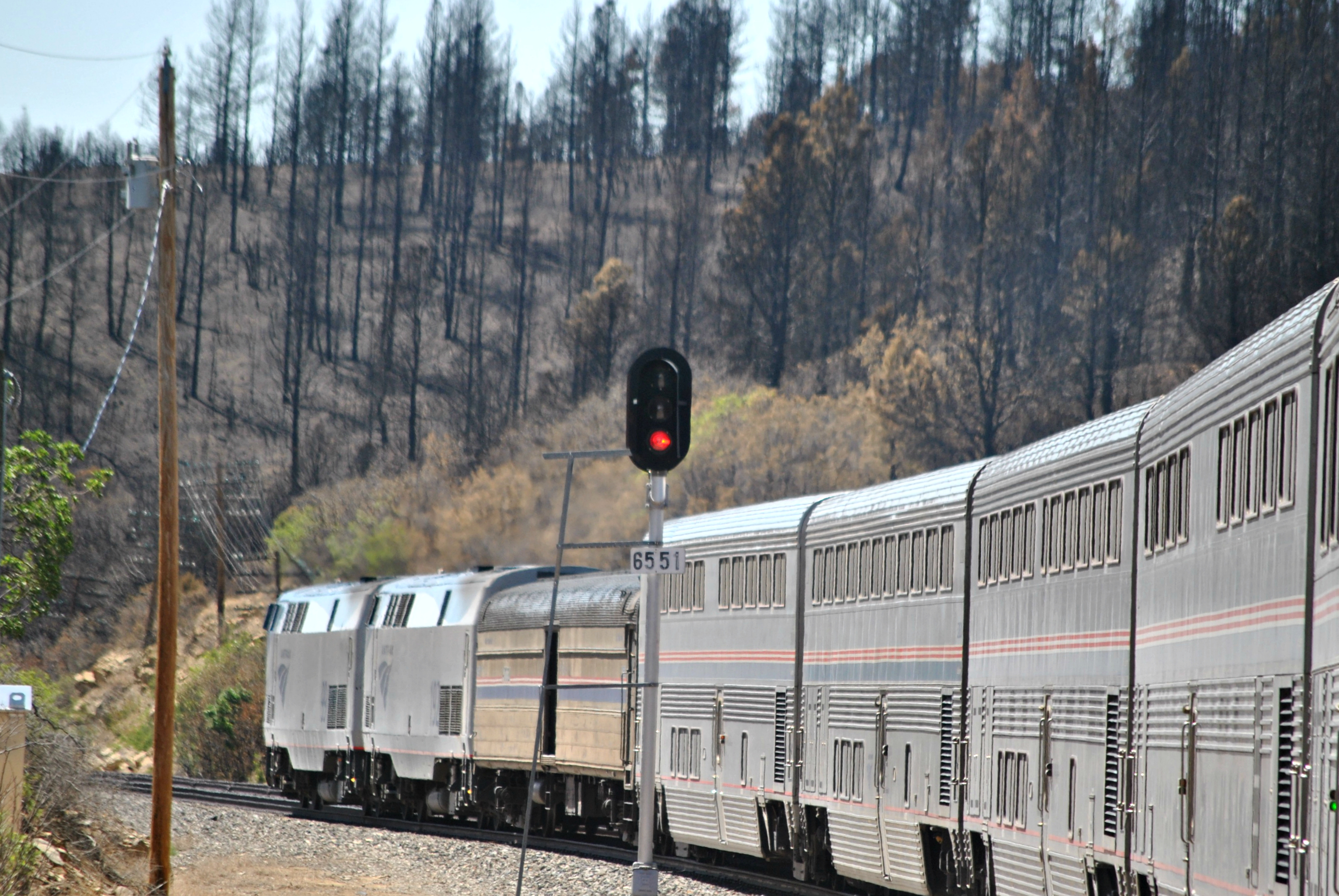
Regular traffic on BNSF's Raton Subdivision today consists solely of Amtrak's Southwest Chief, operating daily in each direction. The westbound #3 typically crosses the pass during mid-morning, climbing from Trinidad to the summit; the eastbound #4 descends the New Mexico side in early evening. Both run as Superliner consists hauled by pairs of GE P42DC or Siemens ALC-42 Charger locomotives.
BNSF ceased regular freight operations over Raton Pass in the early 2000s after the Belen Cutoff (opened 1908) had already diverted most transcontinental freight decades earlier. Today, occasional BNSF maintenance-of-way trains, ballast trains, or rare detour movements may appear, but these are unpredictable and may go weeks or months between occurrences. When freight does run, the steep 3.5% grades on the New Mexico side and up to 4% on the Colorado side force locomotives into full-throttle operation, producing dramatic audio and exhaust.
A notable feature of the Raton Subdivision is that it was home to some of the last active semaphore signals on a US Class I railroad — Union Switch & Signal type T-2 upper-quadrant semaphores dating from the 1920s. As of late 2022, BNSF has been replacing these historic signals, though a handful reportedly still stood at locations like Colmor and Wagon Mound further south on the subdivision.
Passenger trains on this line
- Train 3, to Los AngelesDaily · changed Oct 4≈ 8:49 AMestimated from Raton, 12 km
- Train 4, to ChicagoDaily · changed Oct 4≈ 4:37 PMestimated from Raton, 12 km
Scheduled times from Amtrak’s official timetable, updated October 4, 2026 — trains often run late. Estimated times are worked out along the line from the nearest scheduled stop.
On the line here
FRA / NTAD — crossing inventory Jul 21, 2026 · bridge inventory Oct 14, 2022 · rail yards (FRA / NTAD)
Photos & videos
 Loco Steve
Attribution-ShareAlike License
Best angles for photos
Photography on Raton Pass requires advance planning due to limited legal access points. The most practical vantage points include:
I-25 Summit Pull-off: At the Colorado–New Mexico state line, a highway pull-off near the "Welcome to Colorful Colorado" sign offers a view of the tracks emerging from the 1908 Raton Tunnel. A telephoto lens (200mm+) is useful here to compress the train against the tunnel portal and surrounding rock cuts. Morning light favors the westbound Chief on the New Mexico side; evening light is better for the Colorado descent.
Goat Hill Overlook (Raton): Accessible from Moulton Avenue off South 2nd Street in Raton, this city park sits at an elevated vantage above the town. While it's primarily a scenic overlook of the Santa Fe Trail route and surrounding mesas, it offers a distant but panoramic perspective of the railroad's climb out of Raton. Best for wide-angle establishing shots rather than tight train portraits.
I-25 Highway Parallels: Several spots where I-25 runs close to the railroad between Trinidad and the summit allow roadside photography from interstate shoulders or rest areas. Use extreme caution with highway traffic. The best compositions are where the railroad's tight curves contrast with the surrounding canyon walls and sandstone cliffs.
Compass orientation: the railroad runs roughly north-south through the pass, so morning sun illuminates the east-facing rock walls and afternoon sun the west side. Winter's low-angle light creates dramatic shadows in the canyon.
The full guide
Trainspotting Experience
Raton Pass sits on the Colorado–New Mexico state line along BNSF's Raton Subdivision, the original Atchison, Topeka & Santa Fe transcontinental main line. The railroad climbs from Trinidad, Colorado (elevation ~6,000 ft) to the summit tunnel at 7,588 ft over roughly 10 miles of winding track, paralleling Interstate 25 and Raton Creek through a narrow canyon. Today the only regular traffic is Amtrak's Southwest Chief — trains #3 (westbound) and #4 (eastbound) — making this a low-volume, high-drama location where every passage counts.
Access for railfans is limited compared to busier corridors. I-25 parallels the tracks and several pull-offs along the highway afford glimpses of the railroad below, though many older access roads on the New Mexico side have been gated. The old Raton Pass Road, branching from Goat Hill in Raton, follows the historic Santa Fe Trail alignment and offers elevated vantage points, though vehicle access beyond the first gate is restricted — the road is walkable on foot. On the Colorado side, Exit 2 (Wootton) off I-25 is also gated. Railfans should plan around Amtrak's schedule and arrive early to scout legal vantage points along the interstate pull-offs.
Landscape, Setting & Local Atmosphere
The pass cuts through the Raton Range of the eastern Sangre de Cristo Mountains, a landscape of rust-colored sandstone outcrops, volcanic mesas, piñon-juniper woodland, and ponderosa pine. The terrain is semi-arid at nearly 7,800 ft elevation, with thin, crisp air that carries locomotive sounds for miles across the canyon.
To the south, the flat-topped mesas of northeastern New Mexico stretch to the horizon, while to the north the foothills roll toward Trinidad and the Spanish Peaks beyond. Summer brings vivid blue skies punctuated by afternoon thunderheads; winter can blanket the scene in snow, closing I-25 during severe storms. The overall atmosphere is one of isolation and rugged beauty — aside from interstate traffic, the surrounding country is sparsely populated ranchland unchanged in character since the Santa Fe Trail era.
Historical or Cultural Relevance
Raton Pass has been a critical transportation corridor since the Santa Fe Trail era (1821–1880). Mountain man Richens "Uncle Dick" Wootton built a 27-mile toll road over the pass in 1865–66, charging wagons $1–$2 for passage. When the Atchison, Topeka & Santa Fe Railway decided to build west, company president William Barstow Strong dispatched engineers Albert Robinson and Ray Morley to secure the pass ahead of rival Denver & Rio Grande Railway in 1878. Morley befriended Wootton, who agreed to grant the Santa Fe right-of-way in exchange for lifetime railroad passes and groceries.
The AT&SF completed a temporary track with switchbacks and 6% grades in late 1878. A permanent 2,041-foot tunnel opened in September 1879. As traffic grew, a second 2,787-foot tunnel was completed in 1908, which remains in service today. That same year, the AT&SF opened the Belen Cutoff through central New Mexico, bypassing Raton's punishing grades for a maximum 1.25% gradient. Transcontinental freight shifted to the cutoff, though premier passenger trains — the Super Chief, El Capitan, and Grand Canyon Limited — continued over Raton for decades.
The pass was designated a National Historic Landmark in 1960 for its association with the Santa Fe Trail. It also saw military significance: Stephen Kearny's Army of the West crossed in 1846 during the Mexican-American War, and Colorado Volunteers marched over it in 1862 to reinforce Union forces at the Battle of Glorieta Pass.
What Makes This Spot Different
Raton Pass stands apart for what it represents rather than the volume of trains it offers. This is the steepest main line still in operation on a US Class I railroad, with grades reaching 3.5% on the New Mexico side and reportedly 4% on the Colorado approach — numbers that made it a perpetual operational headache for the Santa Fe and now BNSF. With barely two Amtrak trains daily and virtually no freight since BNSF ceased regular operations in the early 2000s, every passage of the Southwest Chief through the 1908 tunnel is an event worth waiting for.
The subdivision also gained fame among signal enthusiasts as the last refuge of mainline semaphore signals in the United States. The Union Switch & Signal T-2 upper-quadrant semaphores, installed in the 1920s, survived into the 2020s precisely because the low traffic didn't justify replacement — until PTC modernization and infrastructure upgrades finally caught up. The pass's dual significance as both a Santa Fe Trail and railroad landmark, recognized as a National Historic Landmark since 1960, makes it a uniquely layered destination for anyone interested in American transportation history.
Frequently Asked Questions
QHow many trains per day cross Raton Pass?
Currently, only two scheduled trains cross Raton Pass daily: Amtrak's westbound Southwest Chief (#3) and eastbound Southwest Chief (#4). BNSF ceased regular freight operations in the early 2000s, though rare maintenance or detour trains occasionally appear.
QCan you drive to the summit of Raton Pass?
Yes. Interstate 25 crosses Raton Pass at approximately 7,834 feet elevation. There is a pull-off area near the Colorado–New Mexico state line with a historic marker. The old Raton Pass Road from Goat Hill is accessible on foot but gated to vehicle traffic.
QWhat time does the Southwest Chief cross Raton Pass?
Schedules vary seasonally, but typically the westbound #3 crosses the pass during mid-morning hours and the eastbound #4 in early evening. Check amtrak.com for current timetables as times shift throughout the year.
QIs Raton Pass the same as the Santa Fe Trail?
Raton Pass was a key segment of the Mountain Branch of the Santa Fe Trail (1821–1880). The pass was designated a National Historic Landmark in 1960 for this association. Today, portions of the original trail route are still visible near the old Raton Pass Road.
QAre there still semaphore signals on the Raton Subdivision?
As of 2022, BNSF began actively replacing the historic Union Switch & Signal T-2 semaphores dating from the 1920s. A handful may still stand at locations like Colmor and Wagon Mound south of the pass, but their days are numbered. These were among the last active semaphores on a US Class I railroad.
Help improve this page
Spotted something out of date or incorrect? Let our community know.
Around Raton
13 places on Spotatrain within 250 km of Raton — 3 spots, 1 journey, 7 live cams and 2 events.
- Cumbres & Toltec Scenic Railroad 136 km
- Toltec Gorge (C&TS Railroad) 161 km
- Las Vegas, New Mexico — Castaneda Hotel PTZ 168 km
- Santa Express Train — Royal Gorge Route Railroad 174 km
- Chama Yard, New Mexico — North Camera 186 km
- Santa's Holiday Express — Cumbres & Toltec Scenic Railroad 186 km
- Chama Yard, New Mexico — South Camera 186 km
- Chama Depot, New Mexico — Cumbres & Toltec Depot Camera 186 km
- Santa Fe, New Mexico — Rodeo Road Static 200 km
- Dalhart (Rail Crossing) 203 km
- Colorado Springs, Colorado — Joint Line Siding 211 km
- Manitou Springs, Colorado — Pikes Peak Cog Railway Depot 211 km
More Spots in New Mexico
Railway Experiences in the United States
Related Journeys & Mega-Projects
Nearby attractions
- Raton Museum6.2 miles / 10 km
Local history museum housed in a 1906 building, featuring exhibits on the Santa Fe Trail, coal mining, and railroad heritage of Raton and Colfax County.
- Goat Hill Scenic Overlook5 miles / 8 km
City park atop a hill overlooking Raton with panoramic views of the Santa Fe Trail route, surrounding mesas, and the railroad's climb. Features the iconic "RATON" sign and access to old Raton Pass Road.
- Sugarite Canyon State Park12.4 miles / 20 km
State park northeast of Raton featuring a historic coal-mining camp, Lake Maloya, hiking trails, and wildlife viewing in a mountain setting at 6,950–8,350 ft elevation.
- Capulin Volcano National Monument34 miles / 55 km
A 60,000-year-old cinder cone volcano with a paved road to the rim and hiking trails. On clear days, views extend into five states from the summit.
- Shuler Theater6.2 miles / 10 km
Historic 1930 atmospheric-style theater built as a medieval Spanish castle, now a state landmark hosting live performances in downtown Raton.
Hotels & places to stay near Raton
Sources & official links
- Raton Pass - Wikipediaen.wikipedia.org
- Raton Pass - Colorado Encyclopediacoloradoencyclopedia.org
- The Santa Fe Semaphores - Jake Miille Photographyjakemiillephotography.com
- Amtrak Southwest Chief Routewww.amtrak.com
- Raton Pass - Santa Fe Trail Historic Sites (UNM)historic-trails.unm.edu
- Explore Raton - Official Tourismwww.exploreraton.com
- Raton Pass - American-Rails.com (History & Map)www.american-rails.com